Trefilan / Trevilan / Trefilar / Trêvilan / Trêfilar
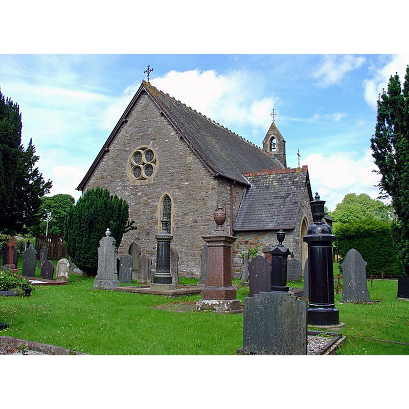
Image copyright © Dylan Moore, 2008
CC-BY-SA-2.0
Results: 1 records
view of church exterior in context - northeast view
Scene Description: present building is a late-18thC re-building
Copyright Statement: Image copyright © Dylan Moore, 2008
Image Source: digital photograph taken 21 July 2008 by Dylan Moore [www.geograph.org.uk/photo/891870] [accessed 22 January 2020]
Copyright Instructions: CC-BY-SA-2.0
INFORMATION
Font ID: 06343TRE
Object Type: Baptismal Font1, base only
Font Century and Period/Style: 12th - 13th century, Medieval
Cognate Fonts: [cf. FontNotes]
Church / Chapel Name: Parish Church of St. Hilary [originally from the old church]
Font Location in Church: Inside the church [cf. FontNotes]
Church Patron Saint(s): St. Hilary of Poitiers
Church Address: Trefilan, Lampeter SA48 8QZ, UK
Site Location: Ceredigion, Wales, United Kingdom
Directions to Site: Located off the B4337, 11 km NNW of Lampeter, 25-30 km SSW of Aberystwyth
Ecclesiastic Region: Diocese of St Davids
Historical Region: Hundred of Ilar -- formerly Cardiganshire
Additional Comments: lost or missing font?: only the base remains / re-cycled font (from the old church) [cf. FontNotes]
Font Notes:
Click to view
Meyrick (1808) writes: "The old church [...] was pulled down in May, 1806, and a new church, consisting simply of a nave, erected in its stead, but of much smaller dimensions. [...] The font is equally ancient with the church, and consists of a square bason supported by a round pillar, somewhat similar to that at Lledrod." Lewis' Dictionary of 1849 reported that the original church "was taken down in 1806, and rebuilt [...] the ancient font, a square basin upon a round pillar, has been preserved". Evans (1914) writes: " A 'nice' new Font, probably introduced in 1882, when the church was reconsecrated." Tyrrell-Green (1928) mentions only the surviving base of an old baptismal font from this church. The entry for this church in COFLEIN [https://coflein.gov.uk/en/site/419334/details/st-hilarys-church-trefilan] [accessed 22 January 2020] notes: "The church was a parish church during the medieval period [...] The church's medieval dedication is thought to have been to St Mary. Its 'Hilary' dedication has been sugested to derive from the place-name, 'Ilan' becoming confused with 'Ilar', the Welsh form of 'Hilary'. [...] The pre-1806 church is thought to have been larger than its successor. The cylindrical font stem and square base (now lying loose in the church) are late twelfth- early thirteenth century in date. It was demolished and entirely rebuilt in 1806, on the same location as its predecessor. The medieval font was retained, but the font bowl had disappeared by 1914. [...] The current church, constructed of local rubble stone, was almost entirely rebuilt in 1880-1882".
COORDINATES
UTM: 30U 423219 5783175
Latitude & Longitude (Decimal): 52.19368, -4.1233
Latitude & Longitude (DMS): 52° 11′ 37.25″ N, 4° 7′ 23.88″ W
MEDIUM AND MEASUREMENTS
Material: stone
Number of Pieces: one [basing missing]
Font Shape: square, mounted
Basin Exterior Shape: square
REFERENCES
- Evans, J.T., The Church Plate of Cardiganshire, Stow-in-the-Wold: James H. Halden, 1914, p. 99
- Lewis, Samuel, A Topographical Dictionary of England, Comprising the Several Counties, Cities, Boroughs, Corporate and Market Towns, Parishes, Chapelries, and Townships, and the Islands of Guernsy, Jersey, and Man, with Historical and Statistical Descriptions [...], London: S. Lewis, 1831, [www.british-history.ac.uk/report.asp?compid=47888] [accessed 23 December 2006]
- Tyrrell-Green, E., Baptismal Fonts Classified and Illustrated, London: Society for Promoting Christian Knowledge: The Macmillan Co., 1928, p. 40
- Wood, Rita, Paradise: the World of Romanesque Sculpture, Layerthorpe, York: Yorl Publishing Services Ltd., 2017, p. 281-282