Noke / Acam / Acham / Noke-on-Otmoor
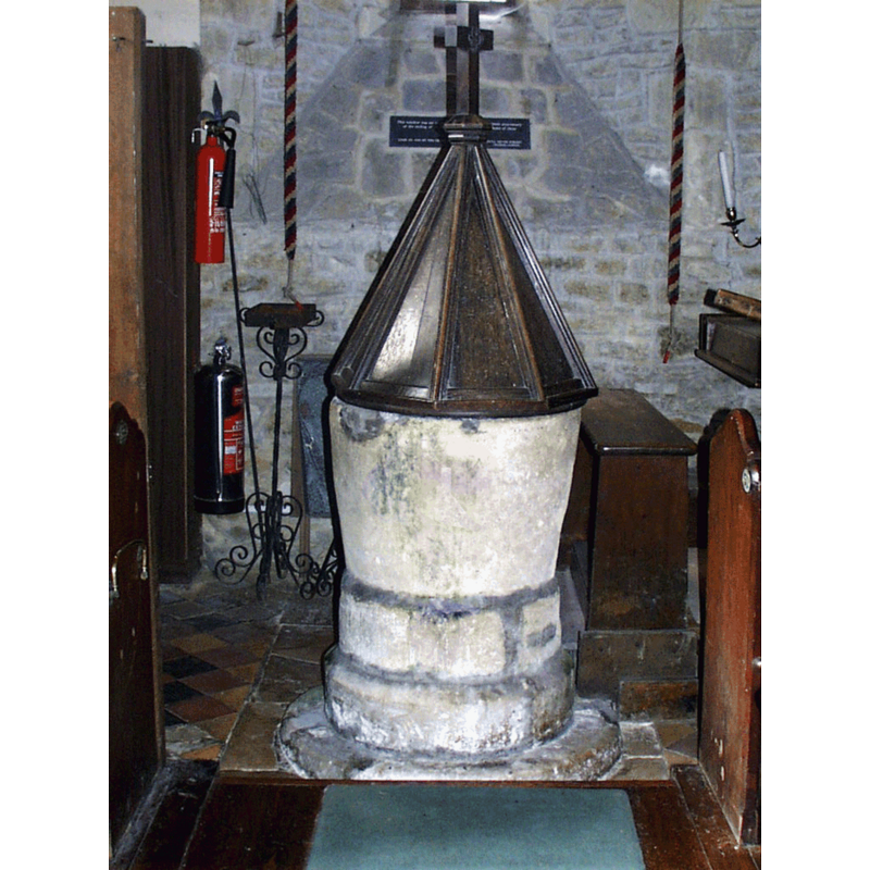
Image copyright © Parish of St. Giles, Noke, 2016
No known copyright restriction / Fair Dealing
Results: 4 records
view of font and cover
Copyright Statement: Image copyright © Parish of St. Giles, Noke, 2016
Image Source: digital photograph in the Homepage of St. Giles, Noke [http://home.btconnect.com/stgiles_noke/church11.gif] [accessed 13 December 2016]
Copyright Instructions: No known copyright restriction / Fair Dealing
view of font and cover in context
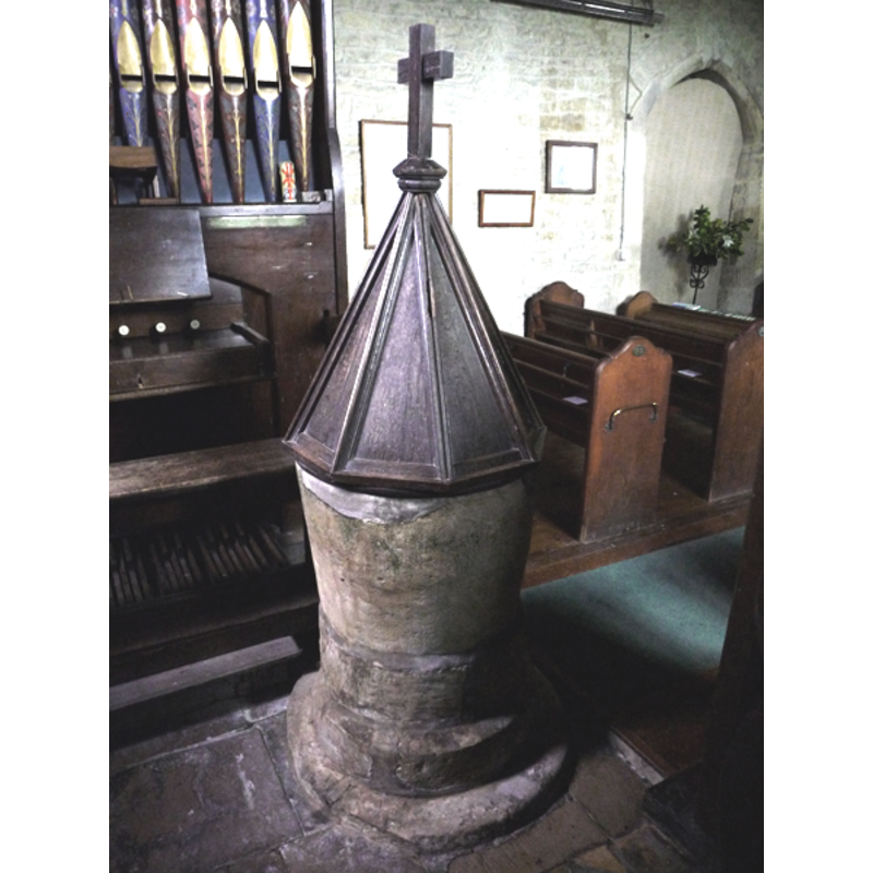
Copyright Statement: Image copyright © John Ward, 2009
Image Source: digital photograph taken 4 May 2009 by John Ward [www.oxfordshirechurches.info]
Copyright Instructions: Standing permission
view of church exterior - southeast view
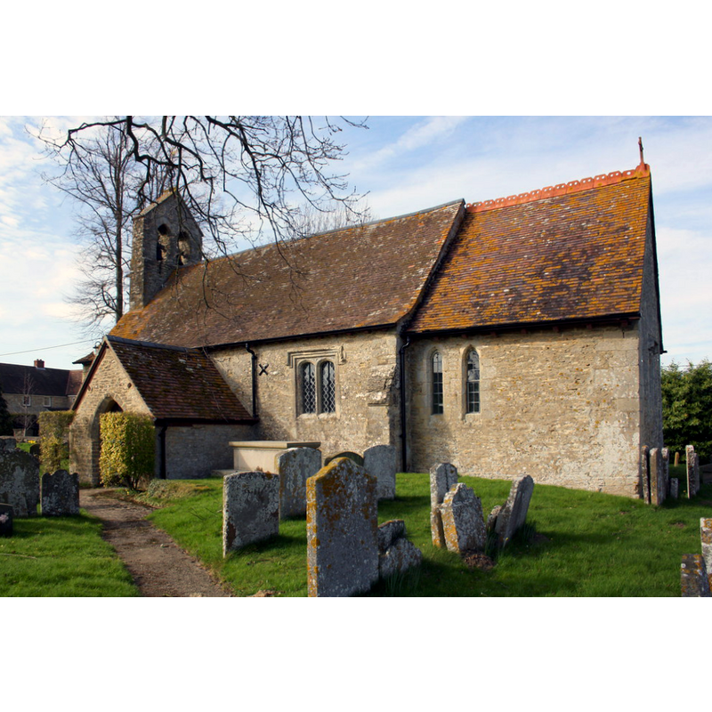
Copyright Statement: Image copyright © Roger Templeman, 2014
Image Source: digital photograph taken 17 March 2014 by Roger Templeman [www.geograph.org.uk/photo/3947758] [accessed 13 December 2016]
Copyright Instructions: CC-BY-SA-2.0
view of church exterior in context - west view
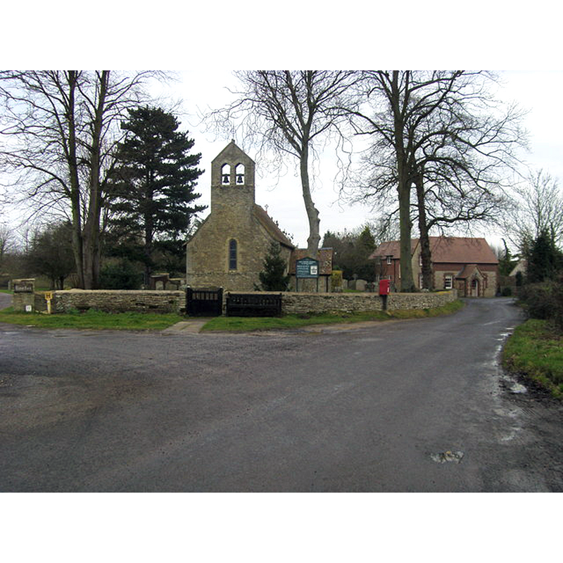
Copyright Statement: Image copyright © Shaun Ferguson, 2008
Image Source: digital photograph taken20 December 2008 by Shaun Ferguson [www.geograph.org.uk/photo/1087142] [accessed 13 December 2016]
Copyright Instructions: CC-BY-SA-2.0
INFORMATION
Font ID: 06315NOK
Object Type: Baptismal Font1
Font Century and Period/Style: 12th - 13th century, Transitional / Early English
Church / Chapel Name: Parish Church of St. Giles
Font Location in Church: Inside the church, in the W end of the nave
Church Patron Saint(s): St. Giles [aka Aegidus, Egidus, Gilles]
Church Address: Noke, Oxfordshire OX3 9TT
Site Location: Oxfordshire, South East, England, United Kingdom
Directions to Site: Located off the B4027, 8 km NNE of Oxford
Ecclesiastic Region: Diocese of Oxford
Historical Region: Hundred of Kirtlington [in Domesday] -- Hundred of Ploughley
Font Notes:
Click to view
There are two entries for Noke in the Domesday survey [http://opendomesday.org/place/SP5413/noke/] [accessed 13 December 2016], neither of which mentions cleric or church in it. The Guide to the Architectural Antiquities in the Neighbourhood of Oxford (1846) reports: "The Font is Early English, of a cylindrical form, larger in circunference at the vertex than at the base, and it stands on a round base, the upper edge of which is chamfered. Its position is between the north and south doors, a little to the west; it is lined with lead, and has a drain, but a pewter basin is used". The font has a pyramidal wooden cover about as tall as the font itself; Latin cross finial. The Victoria County History (Oxford, vol. 6, 1959) notes: "There was a church at Noke at least by 1191, when a priest was first recorded. [...] The church of ST. GILES is a small stone building which has been much restored but dates originally from the first half of the 13th century [...] The cylindrical font is 13th-century and rests on a circular base; [...] the lead basin is marked 'Noke 1773'"; a footnote in the VCH entry (ibid.) refers to a "Buckler drawing in MS. Top. Oxon. a 67, f. 395.", in the Bodleian Library. Sherwood and Pevsner (1974) do not mention mention the font itself but note: "Font cover. C16". The entry for this church in the CRSBI (2016) reports "a plain tapered limestone font of indeterminate age" in it, and adds: "As there was a church on this site at least by 1191, it is possible that the surviving font is Romanesque. However, the font is not mentioned by Sherwood & Pevsner, and is considered to be of 13thc. origin by VCH."
Credit and Acknowledgements: We are grateful to John Ward, of www.oxfordshirechurches.info for his photograph of this font
COORDINATES
UTM: 30U 623284 5741897
Latitude & Longitude (Decimal): 51.8143, -1.2115
Latitude & Longitude (DMS): 51° 48′ 51.48″ N, 1° 12′ 41.4″ W
MEDIUM AND MEASUREMENTS
Material: stone, limestone
Number of Pieces: two
Font Shape: bucket-shaped, mounted
Basin Interior Shape: round
Basin Exterior Shape: round
Drainage System: yes
Drainage Notes: lead-lined
Rim Thickness: 6,5 [calculated]
Diameter (inside rim): 51 cm*
Diameter (includes rim): 64 cm*
Basin Total Height: 47 cm*
Notes on Measurements: CRSBI (2016)
LID INFORMATION
Date: 16th century?
Material: wood
Apparatus: no
Notes: [cf. FontNotes]
REFERENCES
- Victoria County History [online], University of London, 1993-. URL: https://www.british-history.ac.uk.
- Corpus of Romanesque Sculpture in Britain and Ireland, The Corpus of Romanesque Sculpture in Britain and Ireland, The Corpus of Romanesque Sculpture in Britain and Ireland. URL: http://www.crsbi.ac.uk.
- Oxford Society for Promoting the Study of Gothic Architecture, Guide to the Architectural Antiquities in the Neighbourhood of Oxford, A, Oxford: John Henry Parker [for the Society], 1846, p. 202
- Pevsner, Nikolaus, Oxfordshire, Harmondsworth: Penguin Books, 1974, p. 717