Wood Eaton / Etone / Woodeaton
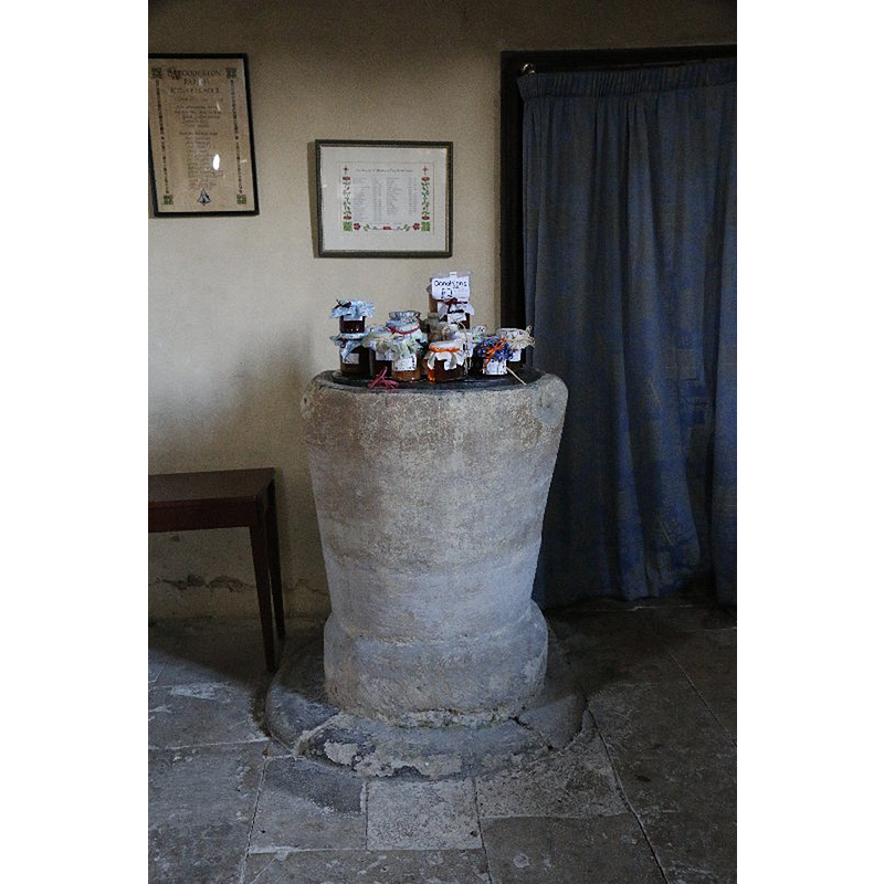
Image copyright © Bill Nicholls, 2014
CC-BY-SA-2.0
Results: 1 records
view of font in context
Scene Description: Source caption: "The font at the back of the Holy Rood in Woodeaton covered in local produce."
Copyright Statement: Image copyright © Bill Nicholls, 2014
Image Source: digital photograph taken 16 January 2014 by Bill Nicholls [www.geograph.org.uk/photo/3885157] [accessed 5 December 2016]
Copyright Instructions: CC-BY-SA-2.0
INFORMATION
Font ID: 06313WOO
Object Type: Baptismal Font1
Font Century and Period/Style: 13th century, Early English
Church / Chapel Name: Parish Church of the Holy Rood
Font Location in Church: Inside the church, in the W end of the nave, beneath the tower arch
Church Patron Saint(s): The Holy Cross
Church Address: Woodeaton, Oxfordshire, OX3 9TN
Site Location: Oxfordshire, South East, England, United Kingdom
Directions to Site: Located 7 km NE of Oxford
Ecclesiastic Region: Diocese of Oxford
Historical Region: Hundred of Headington [in Domesday] -- Hundred of Bullingdon
Additional Comments: damaged font: on opposite ends of the upper rim
Font Notes:
Click to view
There is an entry for [Wood] Eaton [variant spelling] in the Domesday survey [http://opendomesday.org/place/SP5311/wood-eaton/] [accessed 5 December 2016], but it mentions neither cleric nor church in it. The Guide to the Architectural Antiquities in the Neighbourhood of Oxford (1846) notes: "The Font is Early English, plain round". The Victoria County History (Oxford, vol. 5, 1957) notes: "The main fabric of the nave and chancel were probably built in the third quarter of the 13th century [...] The plain cylindrical font is also contemporary with the church, and probably also the niche for baptismal oil east of the north door of the nave." The church plan in the VCH (ibid.) shows the font located beneath the tower arch. The font is not mentioned in Sherwood & Pevsner (1974). The basin tapers in towards the bottom, where it widens slightly with a chamfer; there is considerable damage at opposite sides on the upper rim, probably where the old metal staples of the cover were located; on a round plinth that appears as old as the font. The wooden cover is plain, flat and round; probably modern.
COORDINATES
UTM: 30U 622349 5740639
Latitude & Longitude (Decimal): 51.8032, -1.2255
Latitude & Longitude (DMS): 51° 48′ 11.52″ N, 1° 13′ 31.8″ W
MEDIUM AND MEASUREMENTS
Material: stone
Font Shape: bucket-shaped, unmounted
Basin Interior Shape: round
Basin Exterior Shape: round
Drainage Notes: lead-lined
LID INFORMATION
Date: modern?
Material: wood
Apparatus: no
Notes: [cf. FontNotes]
REFERENCES
- Victoria County History [online], University of London, 1993-. URL: https://www.british-history.ac.uk.
- Oxford Society for Promoting the Study of Gothic Architecture, Guide to the Architectural Antiquities in the Neighbourhood of Oxford, A, Oxford: John Henry Parker [for the Society], 1846, p. 191