Steeple Barton / Bertone
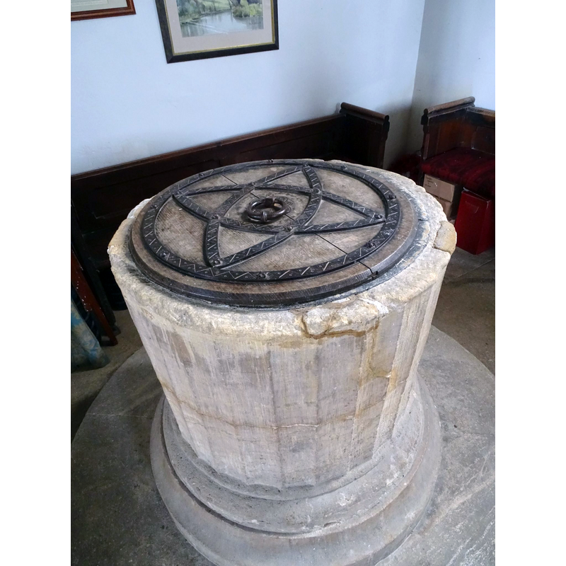
Image copyright © Medieval Mosaic, 2017
No known copyright restriction / Fair Dealing
Results: 6 records
view of font and cover - upper view
Scene Description: showing the decoration of the font cover
Copyright Statement: Image copyright © Medieval Mosaic, 2017
Image Source: digital photograph in Medieval Mosaic [https://medievalmosaic.com/wp-content/uploads/2017/10/DSC00617-2.jpg] [accessed 15 November 2017]
Copyright Instructions: No known copyright restriction / Fair Dealing
view of church exterior - southeast view
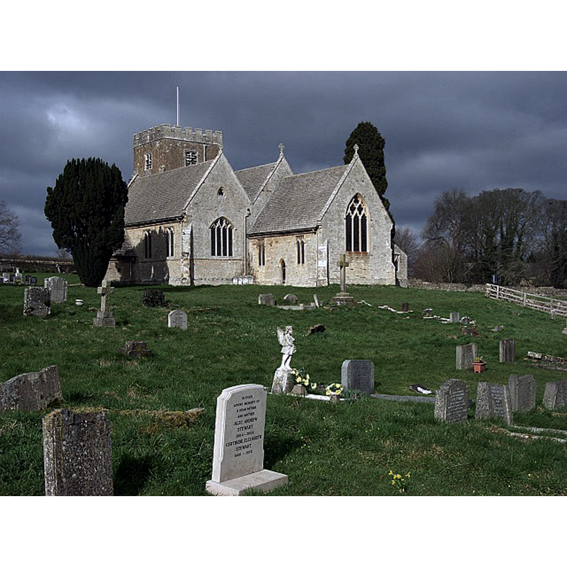
Copyright Statement: Image copyright © Andrew Smith, 2007
Image Source: digital photograph taken 17 March 2007 by Andrew Smith [www.geograph.org.uk/photo/370354] [accessed 15 November 2017]
Copyright Instructions: CC-BY-SA-2.0
view of church exterior - south view
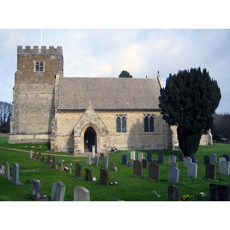
Copyright Statement: Image copyright © Nigel Cox, 2007
Image Source: digital photograph taken 10 March 2007 by Nigel Cox [www.geograph.org.uk/photo/361032] [accessed 15 November 2017]
Copyright Instructions: CC-BY-SA-2.0
view of font - south side

Copyright Statement: Image copyright © Corpus of Romanesque Sculpture in Britain and Ireland, 2017
Image Source: digital image of a photograph by Janet Newson, in the CRSBI (2017) [www.crsbi.ac.uk/site/20/] [accessed 15 November 2017]
Copyright Instructions: PERMISSION NOT AVAILABLE - NOT FOR PUBLIC USE
view of font - northwest side
Copyright Statement: Image copyright © Corpus of Romanesque Sculpture in Britain and Ireland, 2017
Image Source: digital image of a photograph by Janet Newson, in the CRSBI (2017) [www.crsbi.ac.uk/site/20/] [accessed 15 November 2017]
Copyright Instructions: PERMISSION NOT AVAILABLE - NOT FOR PUBLIC USE
view of font and cover
Scene Description: with flowers
Copyright Statement: Image copyright © Corpus of Romanesque Sculpture in Britain and Ireland, 2017
Image Source: digital image of a photograph by Janet Newson, in the CRSBI (2017) [www.crsbi.ac.uk/site/20/] [accessed 15 November 2017]
Copyright Instructions: PERMISSION NOT AVAILABLE - NOT FOR PUBLIC USE
INFORMATION
Font ID: 06304STE
Object Type: Baptismal Font1
Font Century and Period/Style: 12th century?, Late Norman
Church / Chapel Name: Parish Church of St. Mary the Virgin
Font Location in Church: Inside the church, in the S aisle, SW corner
Church Patron Saint(s): St. Mary the Virgin
Church Address: Church Lane, Steeple Barton, Oxfordshire, OX25 4QR, UK
Site Location: Oxfordshire, South East, England, United Kingdom
Directions to Site: Located off (W) the A4260, 14 km S of Banbury, 18 km N of Oxford
Ecclesiastic Region: Diocese of Oxford
Historical Region: Hundred of Wootton
Additional Comments: damaged font (basin broken into several pieces; repaired)
Font Notes:
Click to view
There is an entry for [Steeple] Barton [variant spelling] in the Domesday survey [http://opendomesday.org/place/SP4425/steeple-barton/] [accessed 15 November 2017], but it mentions neither priest nor church in it. The entry for this church in the Guide to the Architectural Antiquities in the Neighbourhood of Oxford (1846): "The font is plain, round, but the sides are fluted with very shallow flutes; the base moulding is Decorated". In Sherwood & Pevsner (1974): "Font. Round and fluted; probably C12." Noted in the Victoria County History (Oxford, vol. 11, 1983): "The church was given to Oseney abbey by Roger of St. John between 1186 and 1190 [...] it was almost completely rebuilt in 1850 and 1851. No traces remain of the 12th-century church [...] The plain tub font is probably 12th-century." Noted and illustrated in the CRSBI (2017): "The only known surviving Romanesque feature may be the fluted font [...] Located in the SW corner of the S aisle. A slightly tapered fluted bucket font of oolitic limestone, with a roll moulding at the base that appears to be integral. It stands on a modern chamfered plinth. The flutes are uniform in width, and the rim shows a layer of mortar above the clean top line of the fluting. Viewed from the W, the flutes are 3 mm shorter on the S side compared with the N. This is complemented by the basal roll moulding being thicker on the S side. There is a lead lining extending on to the rim. Several major cracks to the bowl have been repaired and there is also evidence of damage to the rim [...] The fact that the fluted font is very slightly tapered (the upper circumference is 8 cm larger than the lower) rules out the possibility of it being part of a reused Roman column. There are no similar fonts in Oxfordshire."
COORDINATES
UTM: 30U 613520 5753519
Latitude & Longitude (Decimal): 51.920824, -1.349265
Latitude & Longitude (DMS): 51° 55′ 14.96″ N, 1° 20′ 57.35″ W
MEDIUM AND MEASUREMENTS
Material: stone, limestone (oolitic)
Font Shape: tub-shaped
Basin Interior Shape: round
Basin Exterior Shape: round
Drainage Notes: lead-lined
Rim Thickness: 12 cm [calculated]
Diameter (inside rim): 56 cm*
Diameter (includes rim): 80 cm*
Basin Total Height: 65 cm* [includes lower roll moulding]
Notes on Measurements: * CRSBI (2017)
LID INFORMATION
Date: modern
Material: wood, oak?
Apparatus: no
Notes: round and flat, with metal decoration and ring handle; modern
REFERENCES
- Victoria County History [online], University of London, 1993-. URL: https://www.british-history.ac.uk.
- Corpus of Romanesque Sculpture in Britain and Ireland, The Corpus of Romanesque Sculpture in Britain and Ireland, The Corpus of Romanesque Sculpture in Britain and Ireland. URL: http://www.crsbi.ac.uk.
- Oxford Society for Promoting the Study of Gothic Architecture, Guide to the Architectural Antiquities in the Neighbourhood of Oxford, A, Oxford: John Henry Parker [for the Society], 1846, p. 96
- Pevsner, Nikolaus, Oxfordshire, Harmondsworth: Penguin Books, 1974, p. 788