Sandford St. Martin nr. Chipping Norton / Sanford
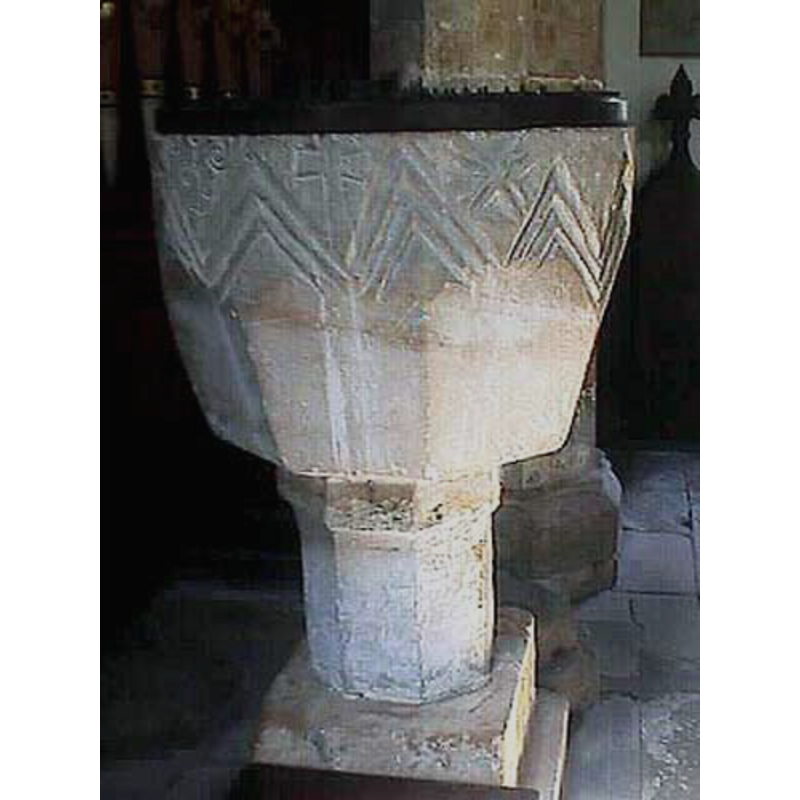
Image copyright © John Wilkes, 2007
Standing permission
Results: 6 records
view of font and cover
Scene Description: [cf. Font notes]
Copyright Statement: Image copyright © John Wilkes, 2007
Image Source: digital photograph by John Wilkes [www.allthecotswolds.com]
Copyright Instructions: Standing permission
design element - motifs - chevron - nested chevrons
Scene Description: on the upper sides of the basin -- [cf. Font notes]
Copyright Statement: Image copyright © John Wilkes, 2007
Image Source: digital photograph by John Wilkes [www.allthecotswolds.com]
Copyright Instructions: Standing permission
symbol - cross
Scene Description: [cf. Font notes]
Copyright Statement: Image copyright © John Wilkes, 2007
Image Source: digital photograph by John Wilkes [www.allthecotswolds.com]
Copyright Instructions: Standing permission
symbol - star?
Scene Description: [cf. Font notes]
Copyright Statement: Image copyright © John Wilkes, 2007
Image Source: digital photograph by John Wilkes [www.allthecotswolds.com]
Copyright Instructions: Standing permission
design element - motifs - floral or foliage
Scene Description: [cf. Font notes]
Copyright Statement: Image copyright © John Wilkes, 2007
Image Source: digital photograph by John Wilkes [www.allthecotswolds.com]
Copyright Instructions: Standing permission
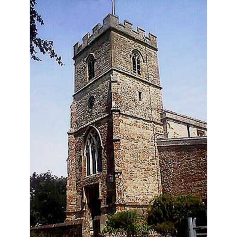
view of church exterior - west tower
Copyright Statement: Image copyright © John Wilkes, 2007
Image Source: digital photograph by John Wilkes [www.allthecotswolds.com]
Copyright Instructions: Standing permission
INFORMATION
Font ID: 06302SAN
Object Type: Baptismal Font1
Font Century and Period/Style: 12th century [re-cut], Medieval [altered]
Church / Chapel Name: Parish Church of St. Martin
Font Location in Church: Inside the church, in the N side of the nave
Church Patron Saint(s): St. Martin of Tours
Church Address: Ledwell Road, Sandford St Martin, Oxfordshire, OX7 7AH, UK
Site Location: Oxfordshire, South East, England, United Kingdom
Directions to Site: Located off (N) the B4030, about 8 km E of Chipping Norton, 15 km SW of Banbury, 20 km NW of Oxford
Ecclesiastic Region: Diocese of Oxford
Historical Region: Hundred of Wootton
Additional Comments: altered font -- re-cut font MUST USE
Font Notes:
Click to view
There is an entry for Sandford [St Martin] [variant spelling] in the Domesday survey [http://opendomesday.org/place/SP4226/sandford-st-martin/] [accessed 16 November 2017], but it mentions neither priest nor church in it. The Guide to the Architectural Antiquities in the Neighbourhood of Oxford (1846) reports: "The font is octagon, cup-shaped, on an octagon shaft, the upper part ornamented with zigzags, and some other Norman ornaments". Noted in Sherwood & Pevsner (1974): "Originally Norman and tub-shaped, with incised zigzag decoration. The lower part has been re-cut and is now octagonal." The entry for this parish in the Victoria County History (Oxon., vol. 11, 1983) notes: "In the late 12th century Sandford church was a chapel of Steeple Barton. Its status was disputed in 1217 but confirmed as that of a chapel, although it paid all episcopal and archidiaconal dues as a parish church [...] The 12th-century font with zigzag carving has been roughly shaped to fit a later octagonal base." Listed and illustrated in the CRSBI (2017): "Most of the motifs on the font that occupy the chevron spaces are incomplete. It seems that the font top must have been trimmed, as noted by CRSBI for the arcaded font at All Saints Church, Sutton Courtenay, Berkshire." This baptismal font was originally tub-shaped, the sides decorated with nested chevron all around, the spandrels filled with a variety of motifs and symbols (cross, stars, etc.), but at some point the mid-to-lower part of the basin was re-cut into an octagonal shape, destroying thus not only the original shape of the vessel but also the rest of the ornamentation on it. It is now mounted on an octagonal pedestal base, plain but for a moulding towards the upper end, and a narrow square plinth. The round wooden cover with metal decoration is probably modern.
Credit and Acknowledgements: We are grateful to John Wilkes, of www.allthecotswolds.com, for his photographs of church and font.
COORDINATES
UTM: 30U 610705 5755261
Latitude & Longitude (Decimal): 51.937044, -1.389613
Latitude & Longitude (DMS): 51° 56′ 13.36″ N, 1° 23′ 22.61″ W
MEDIUM AND MEASUREMENTS
Material: stone
Font Shape: tub-shaped, re-cut
Basin Interior Shape: round
Basin Exterior Shape: round [re-cut]
Rim Thickness: 9.5 cm [calculated]
Diameter (inside rim): 53 cm*
Diameter (includes rim): 72 cm*
Basin Total Height: 46 cm*
Notes on Measurements: * CRSBI (2017)
LID INFORMATION
Date: modern?
Material: wood
Apparatus: no
Notes: [cf. FontNotes]
REFERENCES
- Victoria County History [online], University of London, 1993-. URL: https://www.british-history.ac.uk.
- Corpus of Romanesque Sculpture in Britain and Ireland, The Corpus of Romanesque Sculpture in Britain and Ireland, The Corpus of Romanesque Sculpture in Britain and Ireland. URL: http://www.crsbi.ac.uk.
- Oxford Society for Promoting the Study of Gothic Architecture, Guide to the Architectural Antiquities in the Neighbourhood of Oxford, A, Oxford: John Henry Parker [for the Society], 1846, p. 91
- Pevsner, Nikolaus, Oxfordshire, Harmondsworth: Penguin Books, 1974, p. 751