Duns Tew / Dunstew / Teowe / Tewa / Tewam / Tuuam
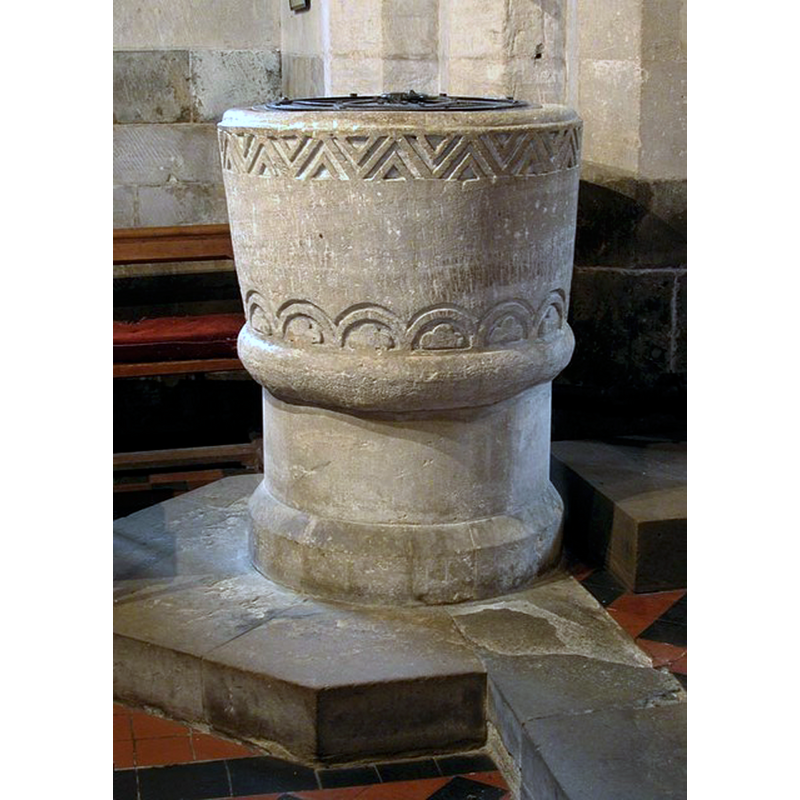
Image copyright © John Salmon, 2009
CC-BY-SA-2.0
Results: 7 records
view of font and cover
Copyright Statement: Image copyright © John Salmon, 2009
Image Source: digital photograph taken 31 May 2003 by Jon Salmon [www.geograph.org.uk/photo/1615247] [accessed 20 November 2017]
Copyright Instructions: CC-BY-SA-2.0
design element - motifs - chevron - nested chevrons
Scene Description: just below the upper rim, all around
Copyright Statement: Image copyright © John Salmon, 2009
Image Source: digital photograph taken 31 May 2003 by Jon Salmon [www.geograph.org.uk/photo/1615247] [accessed 20 November 2017]
Copyright Instructions: CC-BY-SA-2.0
design element - architectural - arch-head - round - double arch-head
Scene Description: each containing a trefoil, all around
Copyright Statement: Image copyright © John Salmon, 2009
Image Source: digital photograph taken 31 May 2003 by Jon Salmon [www.geograph.org.uk/photo/1615247] [accessed 20 November 2017]
Copyright Instructions: CC-BY-SA-2.0
design element - motifs - trefoil
Scene Description: framed in a round arch-head, repested all around
Copyright Statement: Image copyright © John Salmon, 2009
Image Source: digital photograph taken 31 May 2003 by Jon Salmon [www.geograph.org.uk/photo/1615247] [accessed 20 November 2017]
Copyright Instructions: CC-BY-SA-2.0
design element - motifs - roll moulding
Scene Description: appears to be part of the basin; the pedestal base and the plinth are modern.
Copyright Statement: Image copyright © John Salmon, 2009
Image Source: digital photograph taken 31 May 2003 by Jon Salmon [www.geograph.org.uk/photo/1615247] [accessed 20 November 2017]
Copyright Instructions: CC-BY-SA-2.0
view of church exterior - southeast view
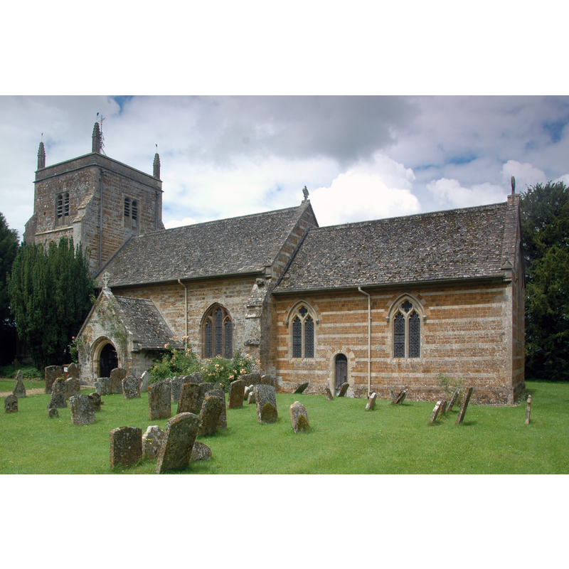
Copyright Statement: Image copyright © Motacilla, 2012
Image Source: digital photograph taken 5 July 2012 by Motacilla [https://commons.wikimedia.org/wiki/File:DunsTew_StMaryMagdalene_south.JPG] [accessed 20 November 2017]
Copyright Instructions: CC-BY-SA-3.0
view of church interior - nave - looking east
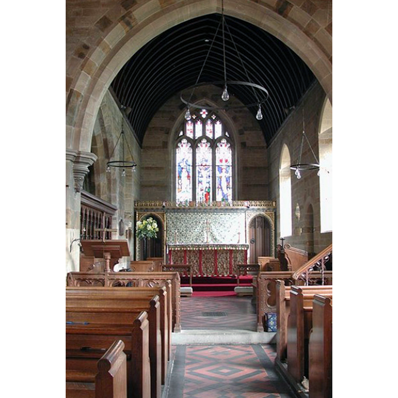
Copyright Statement: Image copyright © John Salmon, 2009
Image Source: digital photograph taken 31 May 2003 by Jon Salmon [www.geograph.org.uk/photo/1615248] [accessed 20 November 2017]
Copyright Instructions: CC-BY-SA-2.0
INFORMATION
Font ID: 06301DUN
Object Type: Baptismal Font1
Font Century and Period/Style: 12th century / 17th century/ [composite font?], Medieval? / Modern?
Church / Chapel Name: Parish Church of St. Mary Magdalene
Font Location in Church: Inside the church, in the nave
Church Patron Saint(s): St. Mary Magdalene
Church Address: Main Street, Duns Tew, Oxfordshire, OX25 6JP, UK
Site Location: Oxfordshire, South East, England, United Kingdom
Directions to Site: Located off (W) the A4260, 4 km S of Deddington, 13 km NNE of Woodstock, 25 km N of Oxford
Ecclesiastic Region: Diocese of Oxford
Historical Region: Hundred of Wootton
Additional Comments: altered font? (is the font an altered Norman font? is it a "clumsy imitation"? [cf. FontNotes])
Font Notes:
Click to view
There are four entries for [Duns] Tew [variant spelling] in the Domesday survey [http://opendomesday.org/place/SP4528/duns-tew/] [accessed 20 November 2017], none of which mentions priest or church in it. Kelly's Oxford Directory of 1911 notes: "the font is doubtfully Transitional". Described in the Guide to the Architectural Antiquities in the Neighbourhood of Oxford (1846): "The font is a clumsy imitation of Norman, probably of the time of Charles II. [i.e., mid- to late-17th cent.] In Sherwood & Pevsner (1974): "Norman, with zig-zag decoration round the rim and a band of arches enclosing trefoils above a modern base." The entry for this parish in the Victoria County History (Oxon. vol. 11, 1983) notes: "Before 1198 the church was given to Merton priory, probably by one of the Tew family who were associated with the priory in the mid 12th century [...] The south doorway and a lancet window in the north wall of the chancel survive from a late 12th- or early 13th-century building [...] The font is probably 12th-century." The font, dated as Norman in Lindsay (1994), is round and decorated with chevron motif around the upper basin side, while the lower side is ornamented with foliage motif.
COORDINATES
UTM: 30U 614350 5757142
Latitude & Longitude (Decimal): 51.953207, -1.335991
Latitude & Longitude (DMS): 51° 57′ 11.54″ N, 1° 20′ 9.57″ W
MEDIUM AND MEASUREMENTS
Material: stone
Font Shape: bucket-shaped, mounted
Basin Interior Shape: round
Basin Exterior Shape: round
LID INFORMATION
Date: modern?
Material: wood, oak?
Apparatus: no
Notes: round anf flat, with metal decoration and ring handle; appears modern
REFERENCES
- Kelly, Kelly's Directory of Oxfordshire, London: Kelly's Directories Ltd., 1911, p. 98 / [http://www.historicaldirectories.org/hd/d.asp] [accessed 30 June 2007]
- Lindsay, J., The Story of Duns Tew, 1994
- Oxford Society for Promoting the Study of Gothic Architecture, Guide to the Architectural Antiquities in the Neighbourhood of Oxford, A, Oxford: John Henry Parker [for the Society], 1846, p. 89
- Pevsner, Nikolaus, Oxfordshire, Harmondsworth: Penguin Books, 1974, p. 590