Letheringsett / Laringseta / Laringsete / Leringaseta / Letheringset / Letheringsete
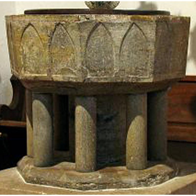
Image copyright © John Salmon, 2006
CC-BY-SA-3.0
Results: 7 records
view of font and cover
Copyright Statement: Image copyright © John Salmon, 2006
Image Source: detail of a digital photograph taken January 2006 by John Salmon [www.norfolkchurches.co.uk/letheringsett/images/img_7551 font.jpg] [accessed 29 January 2014]
Copyright Instructions: CC-BY-SA-3.0
design element - architectural - arcade - blind - pointed arches - 16
Copyright Statement: Image copyright © John Salmon, 2006
Image Source: detail of a digital photograph taken January 2006 by John Salmon [www.norfolkchurches.co.uk/letheringsett/images/img_7551 font.jpg] [accessed 29 January 2014]
Copyright Instructions: CC-BY-SA-3.0
view of church exterior - north view
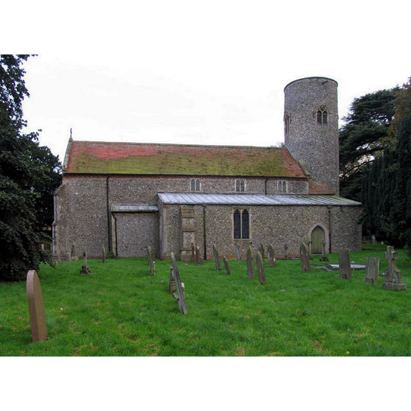
Copyright Statement: Image copyright © John Salmon, 2005
Image Source: digital photograph taken 5 November 2005 by John Salmon [www.geograph.org.uk/photo/319750] [accessed 29 January 2014]
Copyright Instructions: CC-BY-SA-3.0
view of church exterior - southwest view
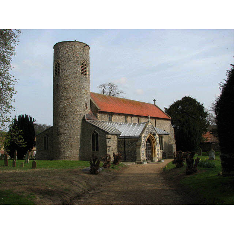
Copyright Statement: Image copyright © Evelyn Simak, 2007
Image Source: digital photograph taken 12 April 2007 by Evelyn Simak [www.geograph.org.uk/photo/1547434] [accessed 29 January 2014]
Copyright Instructions: CC-BY-SA-3.0
view of church exterior - south view
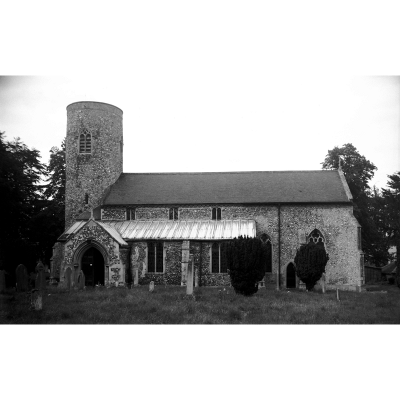
Scene Description: Photo caption: "Norman round tower, the remainder is mainly Decorated"
Copyright Statement: Image copyright © George Plunkett, 2014
Image Source: digital image of a B&W photograph taken 25 August 1956 by George Plunkett [www.georgeplunkett.co.uk/Norfolk/L/Letheringsett St Andrew's church south side [4470] 1956-08-25.jpg] [accessed 29 January 2014]
Copyright Instructions: Standing permission by Jonathan Plunkett
view of font and cover in context
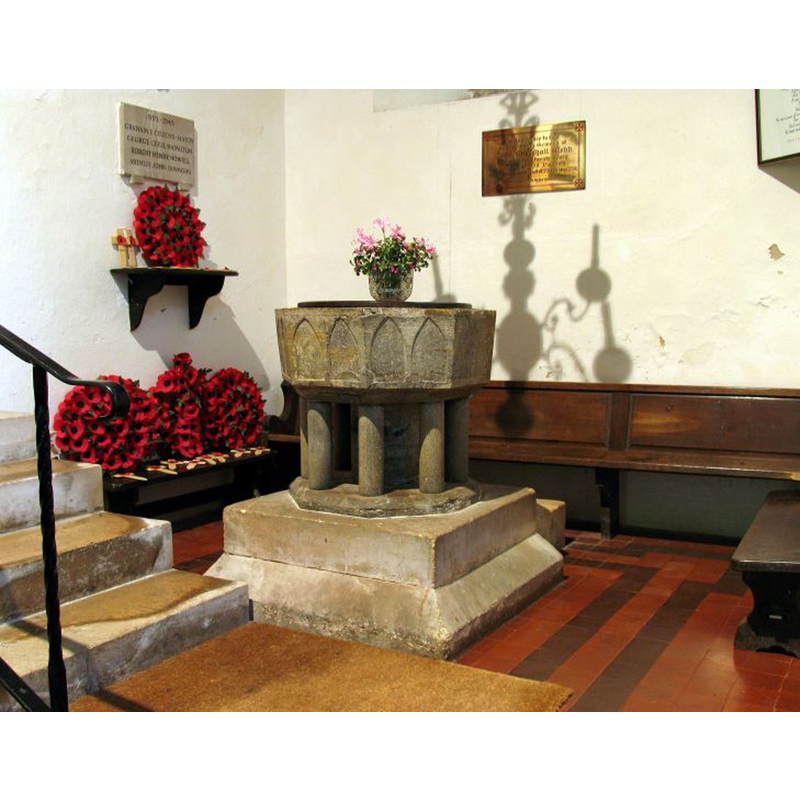
Copyright Statement: Image copyright © John Salmon, 2006
Image Source: digital photograph taken January 2006 by John Salmon [www.norfolkchurches.co.uk/letheringsett/images/img_7551 font.jpg] [accessed 29 January 2014]
Copyright Instructions: CC-BY-SA-3.0
view of church interior - nave - looking east
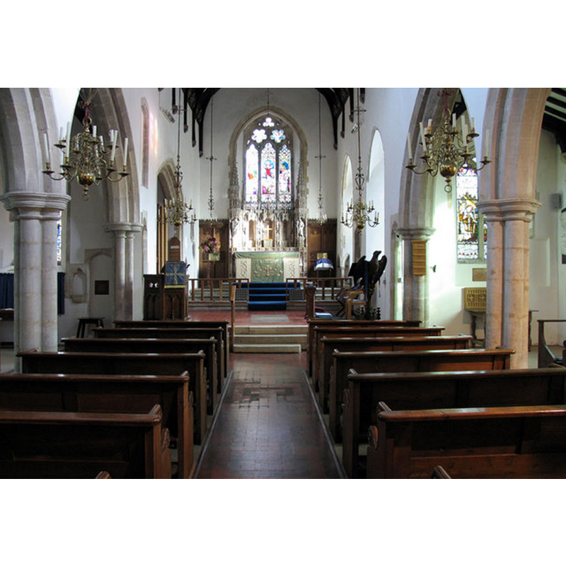
Copyright Statement: Image copyright © John Salmon, 2005
Image Source: digital photograph taken 5 November 2005 by John Salmon [www.geograph.org.uk/photo/319753] [accessed 29 January 2014]
Copyright Instructions: CC-BY-SA-3.0
INFORMATION
Font ID: 05944LET
Object Type: Baptismal Font1
Font Century and Period/Style: 13th century, Early English
Cognate Fonts: Sutton, Beccles, Denham and many others all over England
Church / Chapel Name: Parish Church of St. Andrew
Font Location in Church: Inside the church, at the W end of the S aisle
Church Patron Saint(s): St. Andrew
Church Notes: round-tower church [Norman, ca.1190? [cf. FontNotes]]
Church Address: Holt Road, Letheringsett, Norfolk NR25 7YA
Site Location: Norfolk, East Anglia, England, United Kingdom
Directions to Site: Located on the A148, 2 km NW of Holt, halfway between Fakenham and Cromer (about 18 km either way)
Ecclesiastic Region: Diocese of Norwich
Historical Region: Hundred of Holt
Additional Comments: disappeared font? (the one from the ca.1090 church here)
Font Notes:
Click to view
There are two entries for Letheringsett [variant spelling] in the Domesday survey [http://domesdaymap.co.uk/place/TG0638/letheringsett/] [accessed 29 January 2014], but neither mentions church or cleric in it. Blomefield (1805-1810) writes: "Under the Earl [Walter Giffard Earl of Bucks] it was held about the time of the survey by Grimbald, who built a church here, and gave it to his third son, Edmund. This lord was founder of the family of De Leringset, alias De Bacon. [...] The Church is a rectory dedicated to St. Andrew, and consists, of a nave and 2 isles, a round tower, or steeple, with 3 bells." Lewis' Directory of 1848 describes the font at St. Andrew's as Norman, but Tyrrell-Green (1928) writes: "The octagonal form persisted in fonts of the same class in the thirteenth century, with the change that in the Early English style pointed arches take the place of rounded ones in the shallow incised arcading". Listed in Leach (1975) as a font made of Purbeck marble. Pevsner & Wilson (1997) describe it as a 13th-century octagonal font made of Purbeck marble "with the usual two shallow arches on each side and eight supporting columns" [NB: there is a broad central shaft in addition to the eight outer colonnettes]. Illustrated in Knott (2006). The font appears completely original, including the octagonal lower base; it has been raised on a later quadrangular plinth. The wooden cover is round and flat; appears modern.
COORDINATES
UTM: 31U 369727 5863813
Latitude & Longitude (Decimal): 52.908181, 1.062829
Latitude & Longitude (DMS): 52° 54′ 29.45″ N, 1° 3′ 46.18″ E
MEDIUM AND MEASUREMENTS
Material: stone, limestone (Purbeck marble)
Font Shape: octagonal, mounted
Basin Interior Shape: round
Basin Exterior Shape: octagonal
LID INFORMATION
Date: modern?
Material: wood
Apparatus: no
Notes: [cf. FontNotes]
REFERENCES
- Blomefield, Francis, An essay towards a topographical history of Norfolk, 1805-1810, vol. 9: 411-415 / [www.british-history.ac.uk/report.aspx?compid=78582] [accessed 29 January 2014]
- Knott, Simon, The Norfolk Churches Site, Simon Knott, 2004. [standing permission to reproduce images received from Simon (February 2005]. URL: www.norfolkchurches.co.uk.
- Leach, Rosemary, A Investigation into the use of Purbeck Marble in Medieval England, Hartlepool: E.W. Harrisons & Sons, 1975, p. 77
- Lewis, Samuel, A Topographical Dictionary of England, Comprising the Several Counties, Cities, Boroughs, Corporate and Market Towns, Parishes, Chapelries, and Townships, and the Islands of Guernsy, Jersey, and Man, with Historical and Statistical Descriptions [...], London: S. Lewis, 1831, [www.british-history.ac.uk/report.asp?compid=51104] [accessed 15 February 2007]
- Pevsner, Nikolaus, Norfolk 1: Norwich and North-East [2nd ed.], Harmondsworth: Penguin Books, 1997, p. 585
- Tyrrell-Green, E., Baptismal Fonts Classified and Illustrated, London: Society for Promoting Christian Knowledge: The Macmillan Co., 1928, p. 29, 88