Burnham Thorpe / Bruneham Torp / Burnham Thorp
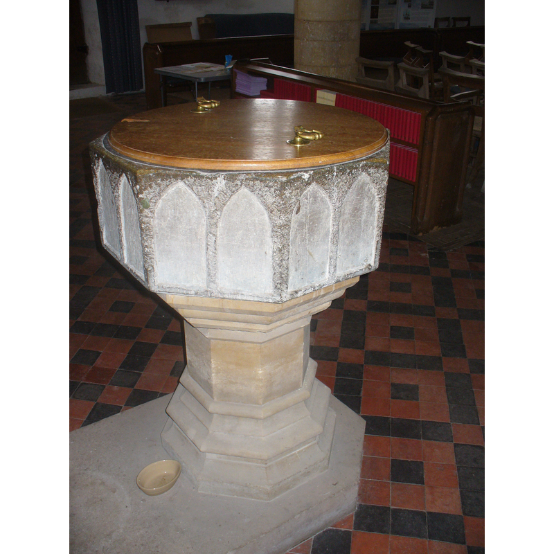
Image copyright © Colin Smith, 2011
Standing permission
Results: 4 records
view of font and cover
Copyright Statement: Image copyright © Colin Smith, 2011
Image Source: digital photograph taken 11 April 2011 by Colin Smith
Copyright Instructions: Standing permission
design element - architectural - arcade - blind - pointed arches - 16
![[cf. Font notes]](/static-50478a99ec6f36a15d6234548c59f63da52304e5/compressed/1110412008_compressed.png)
Scene Description: [cf. Font notes]
Copyright Statement: Image copyright © Colin Smith, 2011
Image Source: digital photograph taken 11 April 2011 by Colin Smith
Copyright Instructions: Standing permission
view of church exterior - northeast view
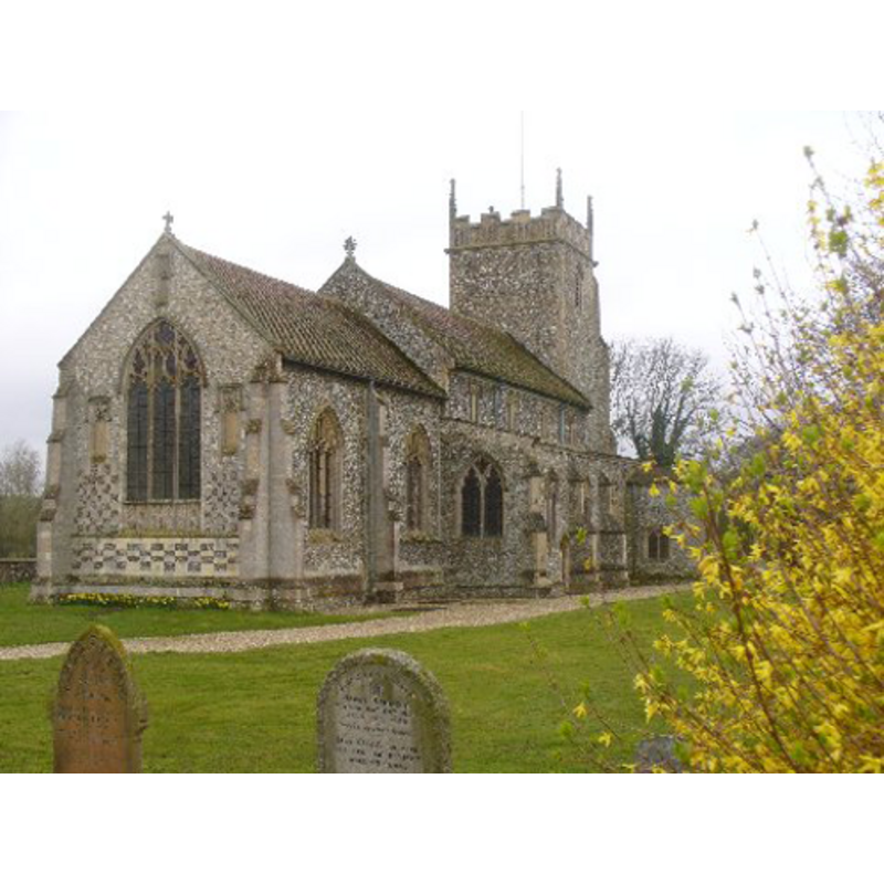
Copyright Statement: Image copyright © Colin Smith, 2011
Image Source: digital photograph taken 11 April 2011 by Colin Smith
Copyright Instructions: Standing permission
view of font and cover in context
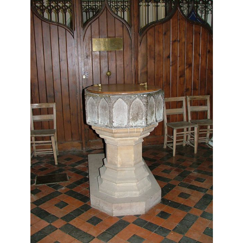
Copyright Statement: Image copyright © Simon Knott, 2009
Image Source: digital photograph taken 7 May 2005 by Simon Knott [http://www.norfolkchurches.co.uk/burnhamthorpe/burnhamthorpe.htm] [accessed 20 July 2009]
Copyright Instructions: Standing permission
INFORMATION
Font ID: 05939BUR
Object Type: Baptismal Font1
Font Century and Period/Style: 13th century [basin only] [composite font], Medieval [composite]
Cognate Fonts: Sutton, Beccles, Denham and many others all over England
Church / Chapel Name: Parish Church of All Saints
Font Location in Church: Inside the church, at the W end of the nave, centre aisle
Church Patron Saint(s): All Saints
Church Address: Walsingham Road, Burnham Thorpe, Norfolk PE31 8HP, United Kingdom
Site Location: Norfolk, East Anglia, England, United Kingdom
Directions to Site: Located just E of the B1355, about 12-14 km NNW of Fakenham
Ecclesiastic Region: Diocese of Norwich
Historical Region: Hundreds of Gallows and Brothercross / Hundred of Gallow [in Domesday]
Additional Comments: famous person font: Admiral Horatio Nelson baptised in it in 1758 -- disppeared font? (the one of the Domesday-time pre-Conquest?] church here [cf. FontNotes])
Font Notes:
Click to view
There are two entries for Burnham Thorp [variant spelling] in the Domesday survey [https://opendomesday.org/place/TF8541/burnham-thorpe/] [accessed 27 February 2023], one of which reports "1 church. 0.66 church lands" in it. Blomefield (1805-1810) writes: "Burnham Thorp [...] Toke, a great Saxon thane, was lord of it in the reign of the Confessor, and was, at the conquest, deprived of it, and many more considerable lordships [...] In Toke's time it contained [...] a church, then endowed with 80 acres [...] The Church is dedicated to All-Saints, and is a rectory [...] It contains a chancel, have with two isles, covered with lead, and a lower with one bell. [...] It appears, that in the reign of Edward I. there was also another church in Burnham Thorp, dedicated to St. Peter, but at that time consolidated to Burnham All-Saints.—Walter de Grancourt gave to the monks of Lewes these two churches; and in 1229, sentence was given in favour of that prior, for an annual pension of 20s. to be paid by the rector of All-Saints, formerly called St. Mary's". Blomefield (ibid.) adds: "Ralph de Cidisterne occurs rector in 1229", the first recorded one here. Tyrrell-Green (1928) lists the font here as part of a group: "The octagonal form persisted in fonts of the same class in the thirteenth century, with the change that in the Early English style pointed arches take the place of rounded ones in the shallow incised arcading". Noted in Pevsner & Wilson (1999): "Of Purbeck marble, octagonal, with two shallow pointed arches to each side. C13." Illustrated in Knott (2005). Only the basin remains from the old font, now mounted on a modern moulded octagonal pedestal base. The wooden cover, flat and round, is also modern. Noted in Leach (1975) as a font made of Purbeck marble, Polygonal I Type (Octagonal): "the supports were replaced when a tower pinnacle fell through the roof about 50 years ago" [i.e., ca. 1925?] [source given: Mr. F.J. Griggs and the Revd. F. Wright quoring the local stone mason].
Credit and Acknowledgements: We are grateful to Simon Knott [www.norfolkchurches.co.uk], and to Colin Smith, for their photographs of church and font
COORDINATES
UTM: 31U 349129 5868077
Latitude & Longitude (Decimal): 52.94109, 0.75479
Latitude & Longitude (DMS): 52° 56′ 27.92″ N, 0° 45′ 17.24″ E
MEDIUM AND MEASUREMENTS
Material: stone, limestone (Puebeck marble)
Font Shape: octagonal, mounted
Basin Interior Shape: round
Basin Exterior Shape: octagonal
Drainage System: centre hole in basin
Drainage Notes: lead-lined
LID INFORMATION
Date: modern
Material: wood, oak?
Apparatus: no
Notes: [cf. FontNotes]
REFERENCES
- Blomefield, Francis, An essay towards a topographical history of Norfolk, 1805-1810, vol. 7: 11-15 / [www.british-history.ac.uk/report.aspx?compid=78292] [accessed 4 June 2013]
- Knott, Simon, The Norfolk Churches Site, Simon Knott, 2004. [standing permission to reproduce images received from Simon (February 2005]. URL: www.norfolkchurches.co.uk.
- Leach, Rosemary, A Investigation into the use of Purbeck Marble in Medieval England, Hartlepool: E.W. Harrisons & Sons, 1975, p. 76
- Pevsner, Nikolaus, Norfolk 2: North-West and South (2nd ed.), London: Penguin, 1999, p. 234
- Tyrrell-Green, E., Baptismal Fonts Classified and Illustrated, London: Society for Promoting Christian Knowledge: The Macmillan Co., 1928, p. 29