Bierton / Beerton / Bierton with Broughton / Bortone / Burton
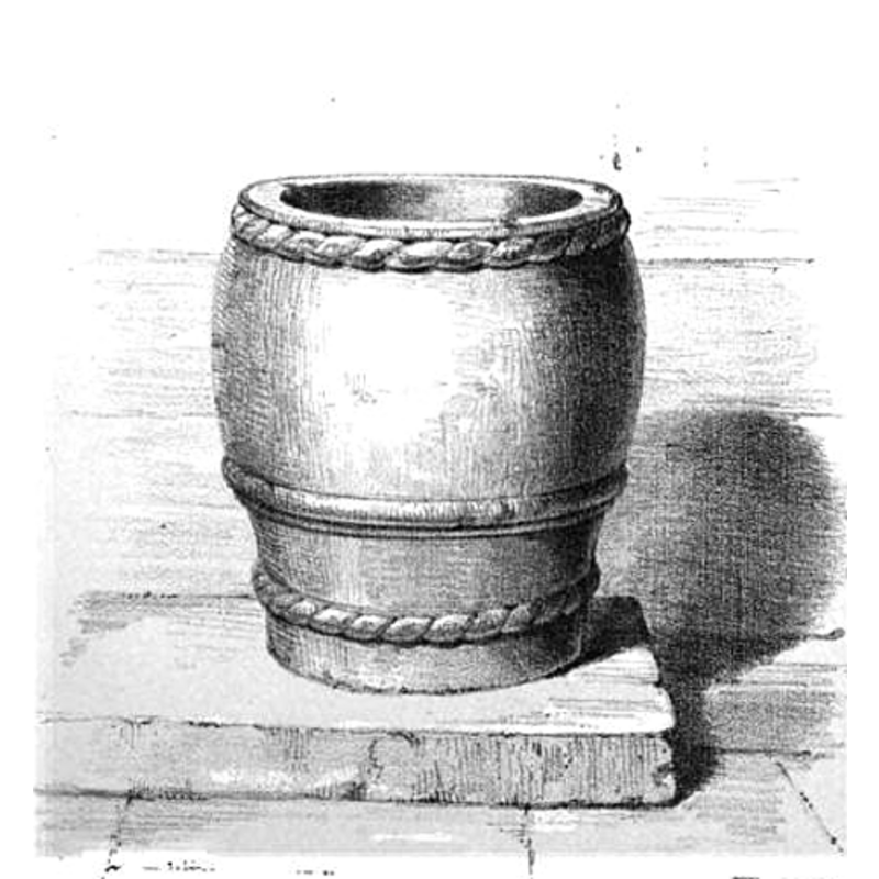
Image copyright © [in the public domain]
PD
Results: 5 records
view of font
Copyright Statement: Image copyright © [in the public domain]
Image Source: engraving [probably by P.H. de la Motte from a drawing by E.A.R.] in Batty (1848)
Copyright Instructions: PD
design element - motifs - rope moulding
Scene Description: [cf. Font notes]
Copyright Statement: Image copyright © [in the public domain]
Image Source: engraving [probably by P.H. de la Motte from a drawing by E.A.R.] in Batty (1848)
Copyright Instructions: PD
design element - motifs - moulding
Scene Description: [cf. Font notes]
Copyright Statement: Image copyright © [in the public domain]
Image Source: engraving [probably by P.H. de la Motte from a drawing by E.A.R.] in Batty (1848)
Copyright Instructions: PD
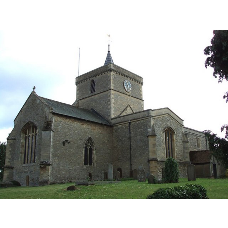
view of church exterior
Copyright Statement: Image copyright © Rob Farrow, 2006
Image Source: digital photograph taken 6 July 2006 by Rob Farrow [http://www.geograph.org.uk/photo/197652]
Copyright Instructions: CC-BY-SA-2.0
design element - motifs - rope moulding
Scene Description: [cf. Font notes]
Copyright Statement: Image copyright © [in the public domain]
Image Source: engraving [probably by P.H. de la Motte from a drawing by E.A.R.] in Batty (1848)
Copyright Instructions: PD
INFORMATION
Font ID: 05920BIE
Object Type: Baptismal Font1
Font Century and Period/Style: 12th century (late?), Norman
Cognate Fonts: [cf. FontNotes]
Church / Chapel Name: Parish Church of St. James the Great
Font Location in Church: Inside the church, at the W end of the S aisle, by the last pillar of the arcade that separates it from the nave
Church Patron Saint(s): St. James the Greater [aka James the Great, James the Elder]
Church Address: Aylesbury Road, Bierton, Buckinghamshire, HP22 5DG
Site Location: Buckinghamshire, South East, England, United Kingdom
Directions to Site: Located on the A418, 1 km NNE of Aylesbury
Ecclesiastic Region: Diocese of Oxford
Font Notes:
Click to view
There is an entry for Bierton [variant spelling] in the Domesday survey [http://opendomesday.org/place/SP8415/bierton/] [accessed 25 September 2015], but it mentions neither cleric nor church in it. A font here is described and illustrated in Batty (1848) [probably an engraving by P.H. de la Motte from a drawing by E.A.R.] (1848): "A peculiar tub-shaped bowl, with stem of nearly the same circumference, having cable mouldings round the rim and stem, and semicircular moulding with fillet at the depth of the bowl. The plinth, if any, is covered by a modern deal step." Noted in Parker (1850): "The font is plain N[orman], with a cable moulding" [Parker (ibid.) refers to a "lithographic print of the font in Batty's Fonts"]. Sheahan (1862) informs that it was "re-lined with lead in 1855". The Victoria County History (Buckingham, vol. 2, 1908) notes: "The circular font is rather plain, with a cable moulding round the top, and of late 12thcentury date." The RCAHM (Buckinghamshire, 1912) notes: "Font: circular bowl, tub-shaped, with cable mouldings, late 12th-century." Described in Tyrrell-Green (1928) as a mounted baptismal font of the Norman period ornamented solely with a rope moulding. Tyrrell-Green (ibid.) gives a list of such fonts which includes: Bierton (Bucks.), Egloskerry (Cornwall), Launcells Cornwall), Tremaine (Cornwall), Wick (Glam), Tresmere (Cornwall), Notgrove (Gloucs.), Folkton (NYorks.), Backwell (Somerset), Congresbury (Somerset). Noted in Pevsner (1960). Noted in the Historic Churches Preservation Trust, Recent Grants [...] 16 March 2006 [www.historicchurches.org.uk]: "Font is late Saxon/early Norman, probably from earlier church on site."
COORDINATES
UTM: 30U 652403 5744355
Latitude & Longitude (Decimal): 51.8292, -0.7883
Latitude & Longitude (DMS): 51° 49′ 45.12″ N, 0° 47′ 17.88″ W
MEDIUM AND MEASUREMENTS
Material: stone
Font Shape: tub-shaped
Basin Interior Shape: round
Basin Exterior Shape: round
Drainage Notes: lead-lined [cf. FontNotes]
Diameter (includes rim): 76.75 cm*
Basin Depth: 39.5 cm*
Font Height (less Plinth): 70 cm*
Font Height (with Plinth): 97.5 cm*
Notes on Measurements: * [in inches, in Batty (1848)]
REFERENCES
- Victoria County History [online], University of London, 1993-. URL: https://www.british-history.ac.uk.
- Batty, Robert Eaton, Some particulars connected with the history of baptismal fonts: being a paper read at the quarterly general meeting of the Architectural and Archaeological Society for the County of Buckingham, London: F. & J. Rivington, 1848, unpaged / [http://books.google.ca/books?id=9BQEAAAAQAAJ&dq=batty's+fonts&printsec=frontcover&source=bl&ots=VzLkyrBnfH&sig=vUl3QIP5ocRlekX_1pHvBes7n7s&hl=en&ei=3gPhSc2hHIyONZ_zkf4I&sa=X&oi=book_result&ct=result&resnum=3#PPA3,M1] [accessed 12 April 2009]
- Great Britain. Royal Commission on Historical Monuments (England), An inventory of the historical monuments in Buckinghamshire, London: H.M. Stationary Office, 1912-, vol. 1: 47, 48
- Parker, John Henry, The Ecclesiastical and architectural topography of England: Oxfordshire, Oxford, London: Published under the sanction of the Central Commitee of the Archaeological Institute of Great Britain and Ireland [by] John Henry Parker, 1850, [entry no.] 177
- Pevsner, Nikolaus, Buckinghamshire, Harmondsworth: Penguin, 1960, p. 65
- Sheahan, James Joseph, History and topography of Buckinghamshire, comprising a general survey of the county, preceded by an epitome of the early history of Great Britain, London; Pontefract: Longman, Green, Longman, and Roberts; William Edward Bonas [...], 1862, p. 99
- Tyrrell-Green, E., Baptismal Fonts Classified and Illustrated, London: Society for Promoting Christian Knowledge: The Macmillan Co., 1928, p. 26, 79