Brayton / Burtone
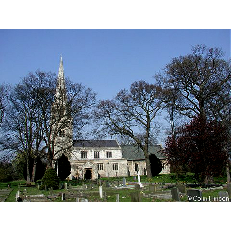
Image copyright © Colin Hinson, 2008
Standing permission
Results: 11 records
view of church exterior - south view
Copyright Statement: Image copyright © Colin Hinson, 2008
Image Source: digital photograph taken in 2008 by Colin Hinson
Copyright Instructions: Standing permission
view of church interior - nave - looking east
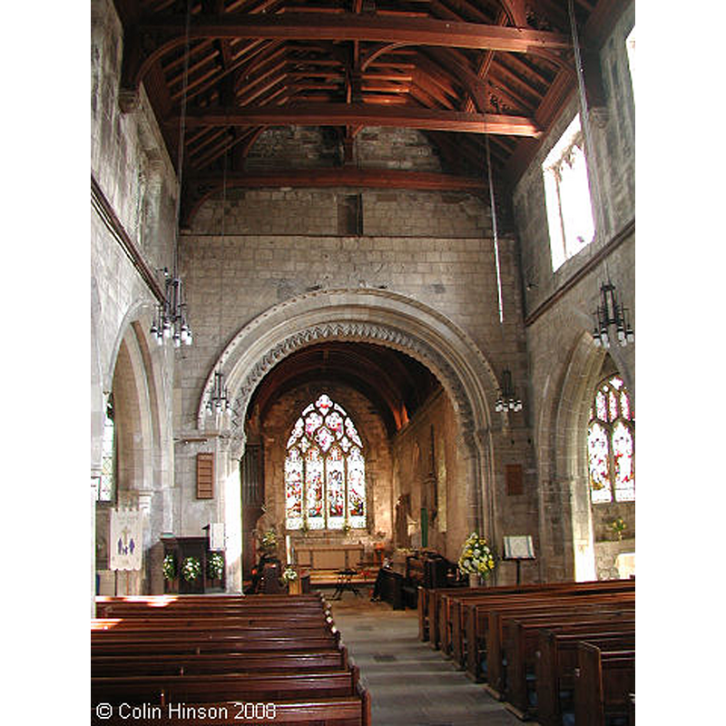
Copyright Statement: Image copyright © Colin Hinson, 2008
Image Source: digital photograph taken in 2008 by Colin Hinson
Copyright Instructions: Standing permission
view of basin - detail

Scene Description: The CRSBI (2018) notes: "The vertical sides are covered with close vertical tooling, and on close inspection and in good lighting can be seen also to have a network of setting-out lines which mark the characteristic 12th c. font decoration of intersected arcading. The photos show this well, and a tracing of part of the surface was enclosed when a report was first submitted. The setting-out marking is as follows: Four horizontal lines, cut in short lengths and not on a lathe. These lines are at 0.13, 0.17, 0.295-0.3 and 0.333m below the top edge. On the top horizontal line, a series of parallel semicircles with radii of 0.1m and 0.075m set out the intersecting arches. The overlap is shown with the curve rising to the right always passing in front of that rising to the left. The centre point can be seen in some cases as a small open pit on the top line. Between the top and bottom pairs of parallel lines, steep diagonal strokes mark the position of the capitals and bases to the arcades. Harder to see, because they run with the vertical tooling, are the lines marking out the columns."
Copyright Statement: Image copyright © CRSBI, 2018
Image Source: B&W photograph taken in 1998 by John McElheran; in CRSBI (2018) [www.crsbi.ac.uk/site/1411/] [accessed 15 October 2018]
Copyright Instructions: PERMISSION NOT AVAILABLE -- IMAGE NOT FOR PUBLIC USE
view of basin - detail
Scene Description: The CRSBI (2018) notes: "The vertical sides are covered with close vertical tooling, and on close inspection and in good lighting can be seen also to have a network of setting-out lines which mark the characteristic 12th c. font decoration of intersected arcading. The photos show this well, and a tracing of part of the surface was enclosed when a report was first submitted. The setting-out marking is as follows: Four horizontal lines, cut in short lengths and not on a lathe. These lines are at 0.13, 0.17, 0.295-0.3 and 0.333m below the top edge. On the top horizontal line, a series of parallel semicircles with radii of 0.1m and 0.075m set out the intersecting arches. The overlap is shown with the curve rising to the right always passing in front of that rising to the left. The centre point can be seen in some cases as a small open pit on the top line. Between the top and bottom pairs of parallel lines, steep diagonal strokes mark the position of the capitals and bases to the arcades. Harder to see, because they run with the vertical tooling, are the lines marking out the columns."
Copyright Statement: Image copyright © CRSBI, 2018
Image Source: B&W photograph taken in 1998 by John McElheran; in CRSBI (2018) [www.crsbi.ac.uk/site/1411/] [accessed 15 October 2018]
Copyright Instructions: PERMISSION NOT AVAILABLE -- IMAGE NOT FOR PUBLIC USE
view of basin - upper view
Scene Description: notice the lead lining; also the metal staple on the outside
Copyright Statement: Image copyright © CRSBI, 2018
Image Source: digital photograph taken 30 July 2014 by Rita Wood; in CRSBI (2018) [www.crsbi.ac.uk/site/1411/] [accessed 15 October 2018]
Copyright Instructions: PERMISSION NOT AVAILABLE -- IMAGE NOT FOR PUBLIC USE
view of font in context
Copyright Statement: Image copyright © CRSBI, 2018
Image Source: digital photograph taken 30 July 2014 by Rita Wood; in CRSBI (2018) [www.crsbi.ac.uk/site/1411/] [accessed 15 October 2018]
Copyright Instructions: PERMISSION NOT AVAILABLE -- IMAGE NOT FOR PUBLIC USE
INFORMATION
Font ID: 05914BRA
Object Type: Baptismal Font1
Font Century and Period/Style: 11th - 12th century [composite font?], Medieval / composite
Cognate Fonts: Similar in general shape: Llanwrthwl, Llanwenog and Upton
Church / Chapel Name: Parish Church of St. Wilfrid
Font Location in Church: Inside the church
Church Patron Saint(s): St. Wilfrid [aka Wilfred, Wilfrith]
Church Address: Doncaster Road, Brayton, North Yorkshire YO8 9HE
Site Location: North Yorkshire, Yorkshire and the Humber, England, United Kingdom
Directions to Site: Located by the A19-A63 junction, just SW of Selby, 22 km S of York
Ecclesiastic Region: Diocese of York
Historical Region: Hundred of Barkston [in Domesday]
Additional Comments: unfinished font MUST USE (arcading incised but never carved) / disused font (for a time; occasional use now) [cf. FontNotes] / composite font [cf. CRSBI in FontNotes)
Font Notes:
Click to view
There is an entry for Brayton [variant spelling] in the Domesday survey [http://domesdaymap.co.uk/place/SE6030/brayton/] [accessed 18 March 2015]; it mentions a church, a priest and one hide of church lands in it. A font here is noted in Glynne's 6 April 1825 visit: "The font is plain and circular." Notes in 'Yorkshire churches', in The Yorkshire Archaeological Journal (vol. 12, 1893: 447) with a similar description. Described in Tyrrell-Green (1928) as an early baptismal stone font consisting of a round basin mounted on a pedestal base. Noted in Morris (1932): Disused, circular font, perfectly plain, and with staples for locking." [NB: as indicated in the CRSBI entry below, there are trace lines to guide the carving of an arcade of the sides of the basin; never completed]. Noted and illustrated in the CRSBI (2018): "There is a plain cylindrical font of squat proportion, with a narrow chamfer at the bottom. It is set on a later drum and square plinth, and stands in the NE corner of the N aisle. The rim is plain and horizontal. Internally the sides are vertical and then rounded into a gently hollowed base. The font is lined. There are several places where it has been damaged, or perhaps the stone was faulty, however it is perfectly serviceable and still occasionally used. The vertical sides are covered with close vertical tooling, and on close inspection and in good lighting can be seen also to have a network of setting-out lines which mark the characteristic 12th c. font decoration of intersected arcading. The photos show this well, and a tracing of part of the surface was enclosed when a report was first submitted. The setting-out marking is as follows: Four horizontal lines, cut in short lengths and not on a lathe. These lines are at 0.13, 0.17, 0.295-0.3 and 0.333m below the top edge. On the top horizontal line, a series of parallel semicircles with radii of 0.1m and 0.075m set out the intersecting arches. The overlap is shown with the curve rising to the right always passing in front of that rising to the left. The centre point can be seen in some cases as a small open pit on the top line. Between the top and bottom pairs of parallel lines, steep diagonal strokes mark the position of the capitals and bases to the arcades. Harder to see, because they run with the vertical tooling, are the lines marking out the columns." Harman & Pevsner (2017) write: "Plain circular Norman bowl, with faintly incised intersected arcading left uncarved."
COORDINATES
UTM: 30U 626103 5959738
Latitude & Longitude (Decimal): 53.77096, -1.086595
Latitude & Longitude (DMS): 53° 46′ 15.46″ N, 1° 5′ 11.74″ W
MEDIUM AND MEASUREMENTS
Material: stone
Number of Pieces: two?
Font Shape: hemispheric, mounted
Basin Interior Shape: round
Basin Exterior Shape: round
Drainage Notes: lead lined
LID INFORMATION
Notes: lock staples present [cf. FontNotes]
REFERENCES
- Corpus of Romanesque Sculpture in Britain and Ireland, The Corpus of Romanesque Sculpture in Britain and Ireland, The Corpus of Romanesque Sculpture in Britain and Ireland. URL: http://www.crsbi.ac.uk.
- Glynne, Stephen Richard, The Yorkshire notes of Sir Stephen Glynne (1825-1874), Woodbridge: The Boydell Press; Yorkshire Archaeological Society, 2007, p. 119
- Harman, Ruth, Yorkshire West Riding: Sheffield and the South, New Haven; London: Yale University Press, 2017, p. 141
- Morris, Joseph Ernest, The West Riding of Yorkshire, London: Methuen & Co., 1932, p. 138
- Tyrrell-Green, E., Baptismal Fonts Classified and Illustrated, London: Society for Promoting Christian Knowledge: The Macmillan Co., 1928, p. 24