Hanwell nr. Banbury / Hanewese [Domesday] (Oxfordshire)
![Main image for Hanwell nr. Banbury / Hanewese [Domesday] (Oxfordshire)](/static-50478a99ec6f36a15d6234548c59f63da52304e5/compressed/1171107003_compressed.png)
Image copyright © Michael Garlick, 2017
CC-BY-SA-2.0
Results: 8 records
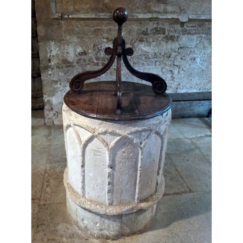
view of font and cover
Copyright Statement: Image copyright © Michael Garlick, 2017
Image Source: digital photograph taken 15 June 2017 by Michael Garlick [www.geograph.org.uk/photo/5485400] [accessed 7 November 2017]
Copyright Instructions: CC-BY-SA-2.0
view of font and cover - upper view
Copyright Statement: Image copyright © Simon Cope, 2013
Image Source: digital photograph taken 6 Sptember 2013 by Simon Cope [www.flickr.com/photos/slim_cop/9728551379/] [accessed 7 November 2017]
Copyright Instructions: CC-BY-SA-2.0
design element - architectural - arcade - blind - round arches - intersecting arches
Scene Description: all around
Copyright Statement: Image copyright © Michael Garlick, 2017
Image Source: digital photograph taken 15 June 2017 by Michael Garlick [www.geograph.org.uk/photo/5485400] [accessed 7 November 2017]
Copyright Instructions: CC-BY-SA-2.0
design element - motifs - roll moulding
Copyright Statement: Image copyright © Michael Garlick, 2017
Image Source: digital photograph taken 15 June 2017 by Michael Garlick [www.geograph.org.uk/photo/5485400] [accessed 7 November 2017]
Copyright Instructions: CC-BY-SA-2.0
view of church exterior - south view - detail
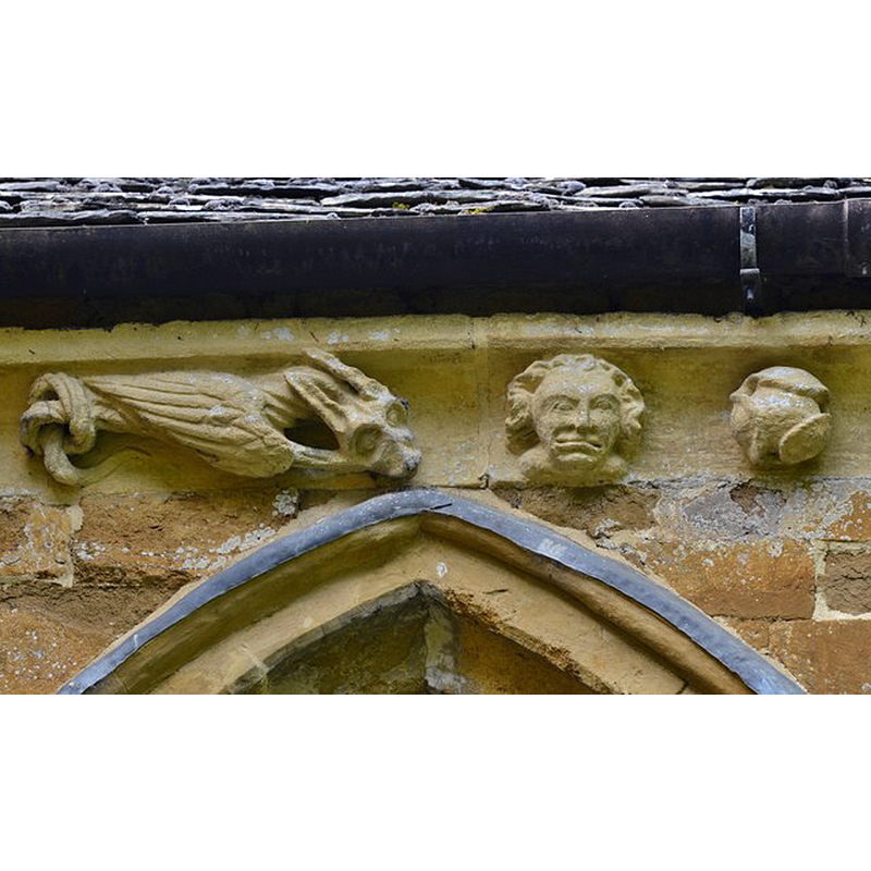
Scene Description: Source caption: "Hanwell, St. Peter's Church: South frieze, ca. 1340: Head and bizarre winged creature with knotted tail" -- a detail of one of the many frieze figures and details on the exterior of this church
Copyright Statement: Image copyright © Michael Garlick, 2017
Image Source: digital photograph taken 15 June 2017 by Michael Garlick [www.geograph.org.uk/photo/5485339] [accessed 7 November 2017]
Copyright Instructions: CC-BY-SA-2.0
view of church exterior - north view
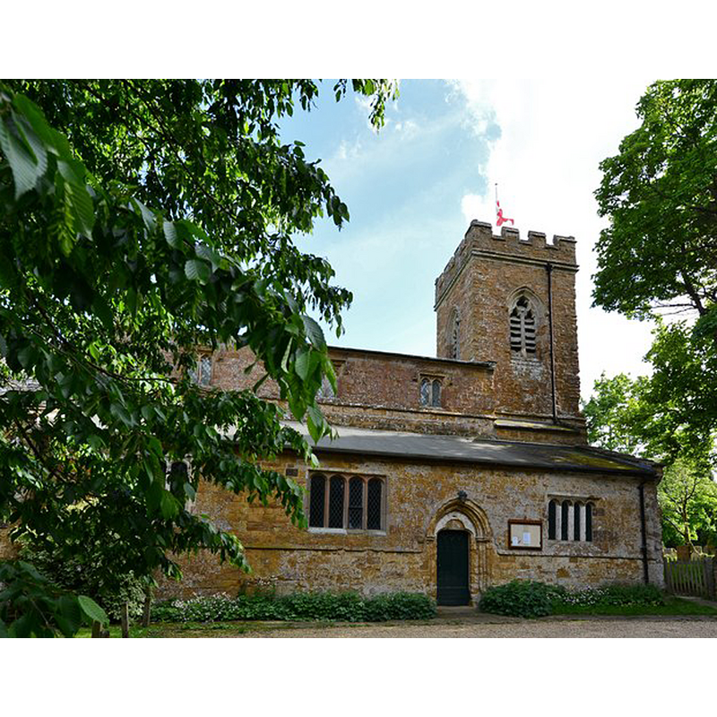
Copyright Statement: Image copyright © Michael Garlick, 2017
Image Source: edited detail of a digital photograph taken 15 June 2017 by Michael Garlick [www.geograph.org.uk/photo/5429508] [accessed 7 November 2017]
Copyright Instructions: CC-BY-SA-2.0
view of church exterior - southwest view
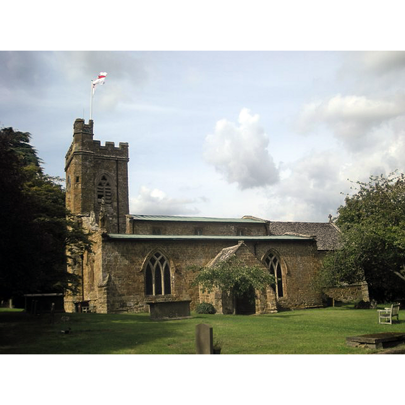
Copyright Statement: Image copyright © Ian Rob, 2011
Image Source: digital photograph taken 23 July 2011 by Ian Rob [www.geograph.org.uk/photo/2518055] [accessed 7 November 2017]
Copyright Instructions: CC-BY-SA-2.0
view of church interior - nave - looking east
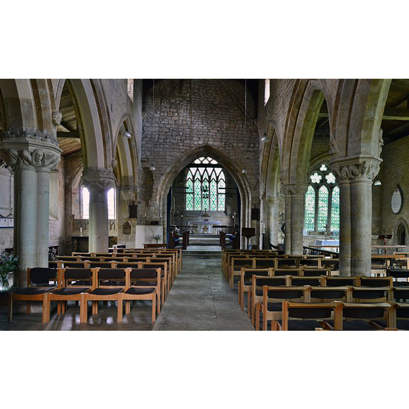
Copyright Statement: Image copyright © Michael Garlick, 2017
Image Source: digital photograph taken 15 June 2017 by Michael Garlick [www.geograph.org.uk/photo/5429514] [accessed 7 November 2017]
Copyright Instructions: CC-BY-SA-2.0
INFORMATION
Font ID: 05860HAN
Object Type: Baptismal Font1
Font Date: ca. 1200?
Font Century and Period/Style: 12th century, Late Norman? / Transitional?
Church / Chapel Name: Parish Church of St. Peter
Font Location in Church: Inside the church, in the S side
Church Patron Saint(s): St. Peter
Church Address: Church Lane, Hanwell, Oxfordshire, OX17 1HN, UK
Site Location: Oxfordshire, South East, England, United Kingdom
Directions to Site: Located 5 km NW of Banbury, between the M40 and the B4100, 40 km NW of Oxford
Ecclesiastic Region: Diocese of Oxford
Historical Region: Hundred of Bloxham
Additional Comments: recycled font? (believed to be from an earlier church)
Font Notes:
Click to view
There is an entry for this Hanewell [variant spelling] in the Domesday survey [http://opendomesday.org/place/SP4343/hanwell/] [accessed 7 November 2017], but it mentions neither priest nor church in it. A Norman font in this church is noted in Beesley's History of Banbury (1841). Lewis' Dictionary of 1848 mentions a Norman font in this church. A baptismal font of the Norman period, ornamented with a blind arcade of intersecting arches is identified in "Notes on the History and Architecture of the Parish" by the Rev. Leslie W.A. Ahrendt, Rector of Hanwell (www.st-peter-hanwell.co.uk/History.htm), the text: "The oldest feature of the Church is the Norman font (in the south aisle), which is tub shaped, and decorated with an interlacing arcade of semicircular headed arches. Mr Keyser, in the British Archaeological Society's Journal, refers to this as a relic of the earlier, Norman Church. The list of Rectors of Hanwell does not begin, however, until 1233 A.D." [source: http://www.hanwellvillage.com/church_history.htm#font [accessed 3 February 2009]. Noted in Kelly's Oxford Directory of 1911: "the font is Transition-Norman". In the Victoria County History (Oxford, vol. 9, 1969): "The only remaining features earlier than 1300 appear to be the font, which is ornamented with intersecting arcading of c. 1200". In Sherwood a& Pevsner (1974): "Font. Norman, tub-shaped, with a blank arcade of intersecting arches. Wooden Jacobean cover, four scrolls supporting a ball finial." Noted in the BRSBI (2017): "The only remaining Romanesque feature is the tub font, with intersecting arches and three little heads [...] Located in the S aisle just W of the S door, a tapered limestone font decorated with intersecting blind arcades and three carved heads. The bowl has a roll moulding below and stands on a modern cylindrical base. There is a lead lining and a drainage hole. There is damage to the stone rim to the SW where the lead lining has been bent over the gap, and to the NE there is repaired lock damage. The font bears raised chamfered ridges that form six round-headed arches, intersecting to form twelve pointed ones. To the SW, near the top, are three projecting carved heads: Head 1, left, in the spandrel of the damaged round arch. A rounded head with hair or headwear, with round depressions for one eye, a nose and a mouth. Head 2, in the top of the next pointed arch to the right, a raised oval shape with depressions for two eyes, and a hollowed mouth containing a tongue. Head 3 shares the space to the right of head 2. It is of similar shape, but too worn to describe. [NB: since the church of St. Peter dates back only to the Early English period, ca. 1230, it is believed the font may have belonged to an earlier, late-Norman or Transitional church].
COORDINATES
UTM: 30U 612013 5772202
Latitude & Longitude (Decimal): 52.089039, -1.365065
Latitude & Longitude (DMS): 52° 5′ 20.54″ N, 1° 21′ 54.23″ W
MEDIUM AND MEASUREMENTS
Material: stone
Font Shape: cylindrical, mounted
Basin Interior Shape: round
Basin Exterior Shape: round
Drainage System: centre hole in basin
Drainage Notes: lead-lined
Diameter (inside rim): 59 cm
Diameter (includes rim): 76 cm
Basin Total Height: 70 cm
Notes on Measurements: CRSBI (2017)
LID INFORMATION
Date: 16th century?
Material: wood
Notes: [cf. FontNotes]
REFERENCES
- Victoria County History [online], University of London, 1993-. URL: https://www.british-history.ac.uk.
- Corpus of Romanesque Sculpture in Britain and Ireland, The Corpus of Romanesque Sculpture in Britain and Ireland, The Corpus of Romanesque Sculpture in Britain and Ireland. URL: http://www.crsbi.ac.uk.
- Kelly, Kelly's Directory of Oxfordshire, London: Kelly's Directories Ltd., 1911, p. 114 / [http://www.historicaldirectories.org/hd/d.asp] [accessed 2July 2007]
- Lewis, Samuel, A Topographical Dictionary of England, Comprising the Several Counties, Cities, Boroughs, Corporate and Market Towns, Parishes, Chapelries, and Townships, and the Islands of Guernsy, Jersey, and Man, with Historical and Statistical Descriptions [...], London: S. Lewis, 1831, [www.british-history.ac.uk/report.asp?compid=51004] [accessed 7 February 2007]
- Pevsner, Nikolaus, Oxfordshire, Harmondsworth: Penguin Books, 1974, p. 631