Scarning / Scerningha
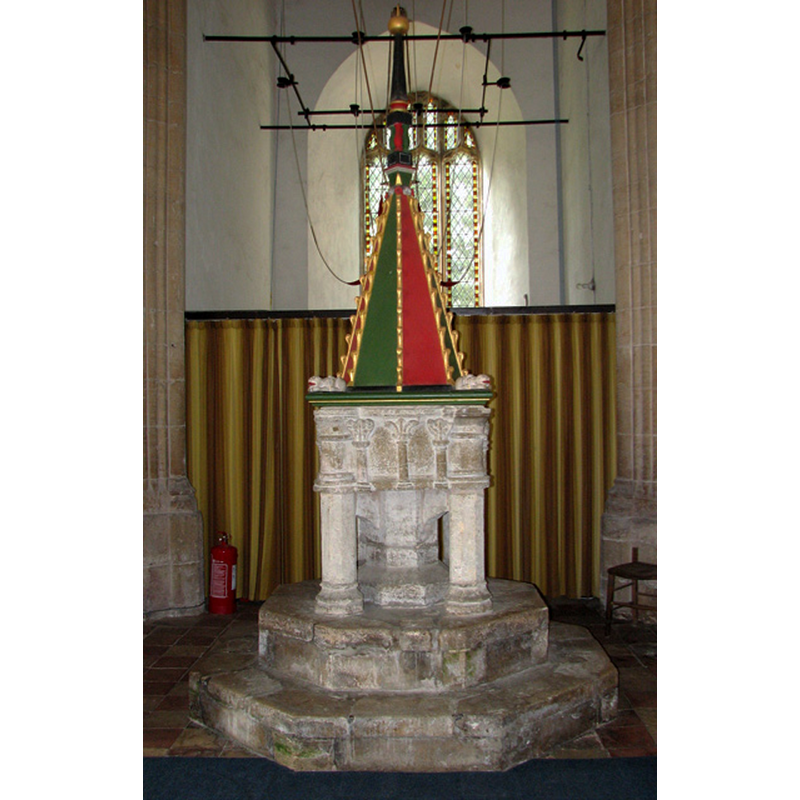
Image copyright © Evelyn Simak, 2010
CC-BY-SA-3.0
Results: 10 records
view of font and cover
Scene Description: [cf. FontNotes]
Copyright Statement: Image copyright © Evelyn Simak, 2010
Image Source: N/Adigital photograph taken 1 September 2010 by Evelyn Simak [www.geograph.org.uk/photo/2050126] [accessed 11 February 2014]
Copyright Instructions: CC-BY-SA-3.0
view of font
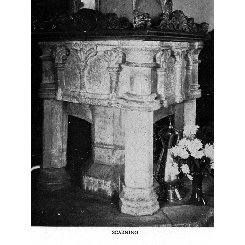
Scene Description: the paltform of the old cover is partially visible here
Copyright Statement: Image copyright © Cautley, 1949
Image Source: Cautley (1949:133)
Copyright Instructions: Standing permission received from the publisher
design element - architectural - column - 4
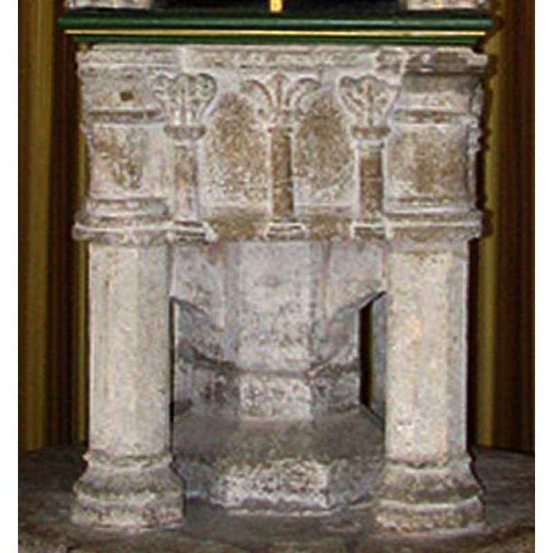
Scene Description: a thick one at each angle of the basin sides
Copyright Statement: Image copyright © Evelyn Simak, 2010
Image Source: detail of a digital photograph taken 1 September 2010 by Evelyn Simak [www.geograph.org.uk/photo/2050126] [accessed 11 February 2014]
Copyright Instructions: CC-BY-SA-3.0
design element - motifs - foliage
Scene Description: three on each side, standing on columnar holders (?)
Copyright Statement: Image copyright © Evelyn Simak, 2010
Image Source: detail of a digital photograph taken 1 September 2010 by Evelyn Simak [www.geograph.org.uk/photo/2050126] [accessed 11 February 2014]
Copyright Instructions: CC-BY-SA-3.0
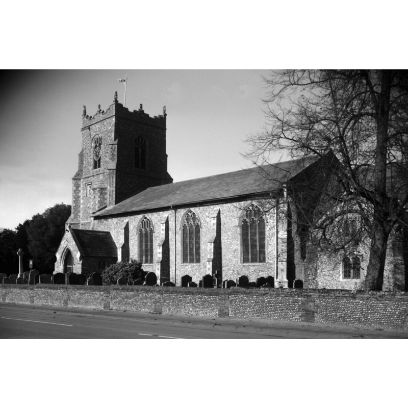
view of church exterior - south view
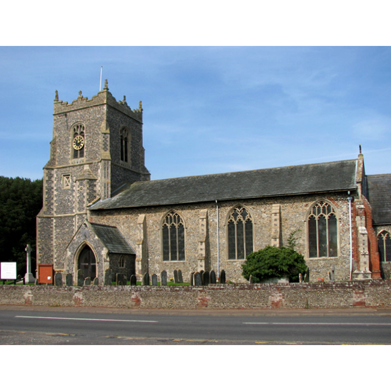
Copyright Statement: Image copyright © Evelyn Simak, 2010
Image Source: digital photograph taken 1 September 2010 by Evelyn Simak [www.geograph.org.uk/photo/2050110] [accessed 11 February 2014]
Copyright Instructions: CC-BY-SA-3.0
view of church exterior - southeast view
Scene Description: Photo caption: "A two-storeyed vestry on the south side of the chancel was built in 1576 as a chantry chapel"
Copyright Statement: Image copyright © George Plunkett, 2014
Image Source: B&W photograph taken16 October 1993 by George Plunkett [www.georgeplunkett.co.uk/Norfolk/S/Scarning Ss Peter and Paul church from SE [7073] 1993-10-16.jpg] [accessed 11 February 2014]
Copyright Instructions: Standing permission by Jonathan Plunkett
view of church interior - chancel - rood-screen, choir-screen; iconostasis

Scene Description: seen from the nave
Copyright Statement: Image copyright © Evelyn Simak, 2010
Image Source: digital photograph taken 1 September 2010 by Evelyn Simak [www.geograph.org.uk/photo/2050116] [accessed 11 February 2014]
Copyright Instructions: CC-BY-SA-3.0
view of church interior - nave - looking west
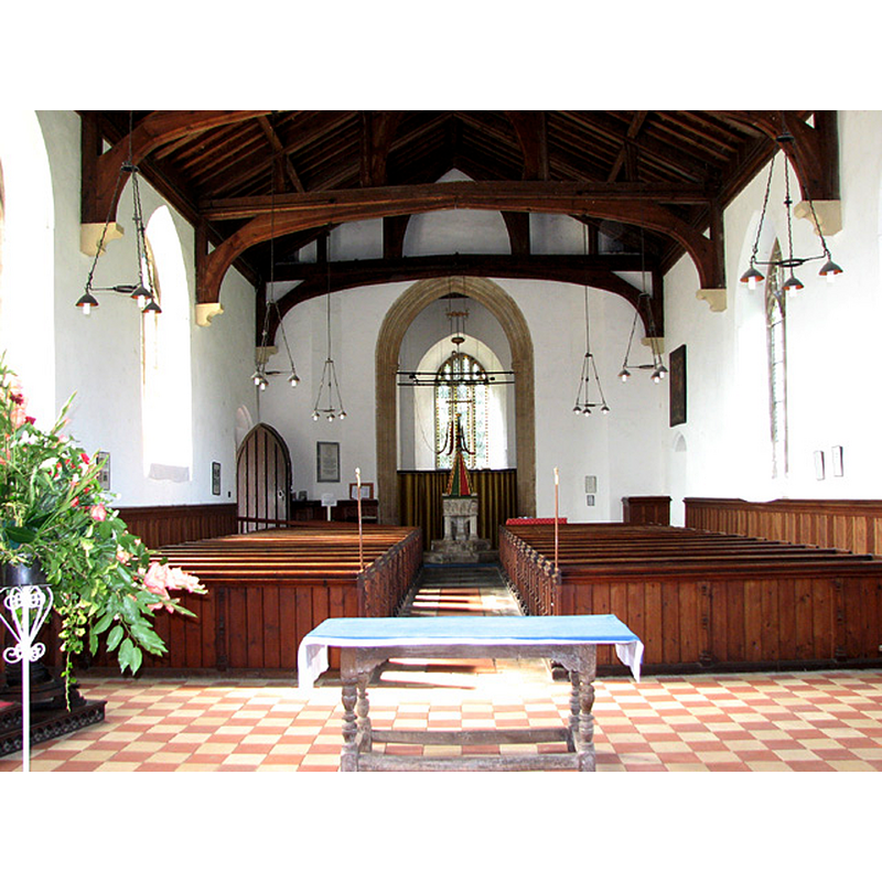
Scene Description: the font and cover are visible at the west end
Copyright Statement: Image copyright © Evelyn Simak, 2010
Image Source: digital photograph taken 1 September 2010 by Evelyn Simak [www.geograph.org.uk/photo/2050125] [accessed 11 February 2014]
Copyright Instructions: CC-BY-SA-3.0
view of church interior - nave - looking east
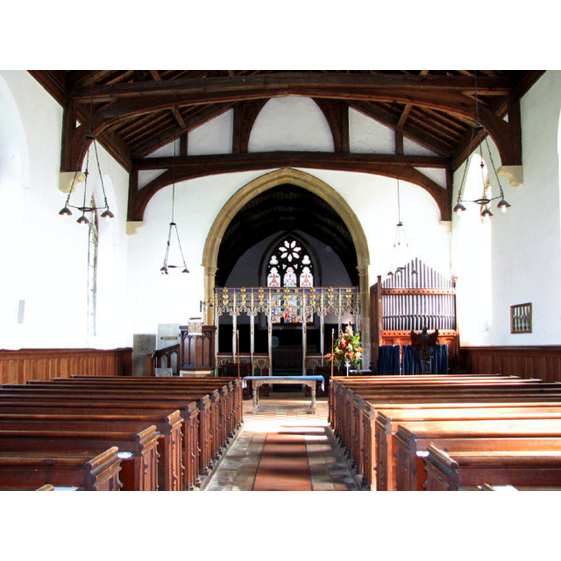
Copyright Statement: Image copyright © Evelyn Simak, 2010
Image Source: digital photograph taken 1 September 2010 by Evelyn Simak [www.geograph.org.uk/photo/205012] [accessed 11 February 2014]
Copyright Instructions: CC-BY-SA-3.0
view of font cover
![the restored cover [cf. FontNotes]](/static-50478a99ec6f36a15d6234548c59f63da52304e5/compressed/1140215011_compressed.png)
Scene Description: the restored cover [cf. FontNotes]
Copyright Statement: Image copyright © Evelyn Simak, 2010
Image Source: detail of a digital photograph taken 1 September 2010 by Evelyn Simak [www.geograph.org.uk/photo/2050126] [accessed 11 February 2014]
Copyright Instructions: CC-BY-SA-3.0
INFORMATION
Font ID: 05773SCA
Object Type: Baptismal Font1
Font Century and Period/Style: 13th century, Early English
Church / Chapel Name: Parish Church of St. Peter and St. Paul
Font Location in Church: Inside the church, at the W end of the nave
Church Patron Saint(s): St. Peter & St. Paul
Church Address: Dereham Road, Scarning, Norfolk NR19 2PE
Site Location: Norfolk, East Anglia, England, United Kingdom
Directions to Site: Located 5-6 km W of East Dereham, now its suburb, about 30 km W of Norwich
Ecclesiastic Region: Diocese of Norwich
Historical Region: Hundred of Launditch
Additional Comments: disappeared font? (the one from the pre-1170 church here)
Font Notes:
Click to view
There are four entries for Scarning [variant spelling] in the Domesday survey [http://domesdaymap.co.uk/place/TF9512/scarning/] [accessed 11 February 2014], but neither mentions a church or cleric in it. Blomefield (1805-1810) writes: "The Church is dedicated to St. Peter and St. Paul, and contained two medieties, one in the patronage of the Franshams, lord of the manor, and the other appropriated to the abbey of Waltham: the first mediety was called the portion of Hugh de Fransham, which was valued at 20 marks, he being rector of it when it was thus taxed in 1256 [...] By an inquisition taken in the reign of Henry II. by Sir Roger Freville, Martin de Helegate, Roger, son of Simon, &c. it was found that Robert de Skerning, who was formerly rector of this church, and lord of a fee, gave the tithes of his fee to the church of Norwich in the time of St. Thomas Becket the Martyr, without any diminution." We can therefore date the founding of this church to between 1086 and 1170, the date of Becket's assassination. The present font is described in Tyrrell-Green (1928) as a baptismal font of the Early English period. Described and illustrated in Cautley (1949) as a 13th-century square stone mounted baptismal font; the basin has thick column motifs at the corners; the sides of the basin are ornamented with foliage motifs on columns. Described in Pevsner & Wilson (1999): "C13. Roughly square, on five supports. Bowl with angle columns and, in the fields between, colonnettes carrying stiff-leaf motifs." The base consists of a central shaft and four outer colonnettes, all octagonal and almost totally plain (the wider central shaft has a thin moulding about 2/3 down. There is a wooden cover or cover frame visible in Cautley's photograph of 1949 (ibid.) [cf. infra]. Described in the town's web site [www.scarning.info/guide.html] [accessed 20 August 2009]: "The font stands at the west end of the nave. The font is massive and dates from the 13th century and shows the Norman influence. The bowl is roughly square, having angle columns and standing on five octagonal columns. The font cover can be raised and lowered by a system of counter-weights and is Jacobean with a restored base"; it is now [2010] brightly painted.
Credit and Acknowledgements: We are grateful to Jonathan Plunkett for the photograph of this church taken by his father, George Plunkett, in October 1993
COORDINATES
UTM: 31U 357230 5837907
Latitude & Longitude (Decimal): 52.672272, 0.888441
Latitude & Longitude (DMS): 52° 40′ 20.18″ N, 0° 53′ 18.39″ E
MEDIUM AND MEASUREMENTS
Material: stone
Font Shape: square, mounted
Basin Interior Shape: round?
Basin Exterior Shape: square
LID INFORMATION
Material: wood
Notes: the frame around the upper rim of the font in Cautley's photograph may be the lid or simply the frame of the lid
REFERENCES
- Blomefield, Francis, An essay towards a topographical history of Norfolk, 1805-1810, vol. 10: 38-47 / [www.british-history.ac.uk/report.aspx?compid=78620] [accessed 11 February 2014]
- Cautley, Henry Munro, Norfolk Churches, Ipswich: Norman Adlard & Co., 1949, p. 21 and ill. p. 133
- Pevsner, Nikolaus, Norfolk 2: North-West and South (2nd ed.), London: Penguin, 1999, p. 631
- Tyrrell-Green, E., Baptismal Fonts Classified and Illustrated, London: Society for Promoting Christian Knowledge: The Macmillan Co., 1928, p. 90, 91