Walsgrave on Sowe / Walsgrave-on-Sowe
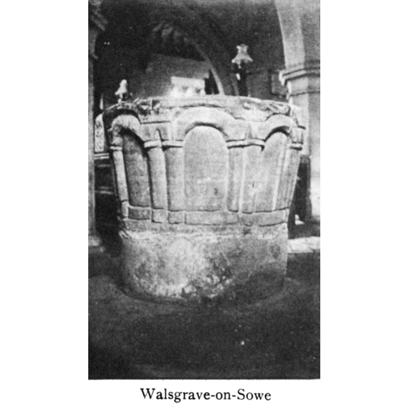
Image copyright © [in the public domain]
PD
Results: 6 records
view of font
Copyright Statement: Image copyright © [in the public domain]
Image Source: digital image of an illustration in Bond (1908)
Copyright Instructions: PD
design element - architectural - arcade - blind - round arches
Copyright Statement: Image copyright © [in the public domain]
Image Source: digital image of an illustration in Bond (1908)
Copyright Instructions: PD
view of church exterior - south view
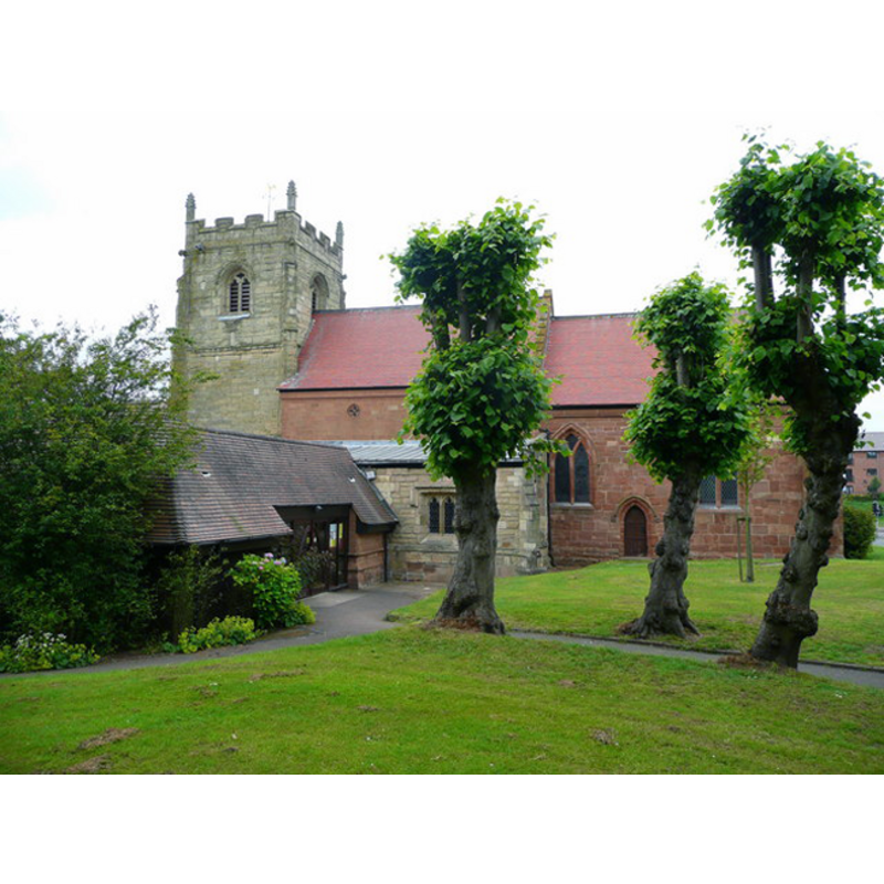
Copyright Statement: Image copyright © Jonathan Billinger, 2008
Image Source: digital photograph taken 2 May 2008 by Jonathan Billinger [www.geograph.org.uk/photo/870668] [accessed 31 May 2012]
Copyright Instructions: CC-BY-SA-3.0
view of church interior - looking east
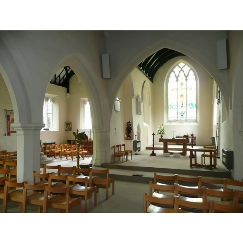
Scene Description: the eastern side of the nave and aisle
Copyright Statement: Image copyright © Jonathan Billinger, 2008
Image Source: digital photograph taken 2 May 2008 by Jonathan Billinger [www.geograph.org.uk/photo/870911] [accessed 31 May 2012]
Copyright Instructions: CC-BY-SA-3.0
view of font

Copyright Statement: Image copyright © The Corpus of Romanesque Sculpture in Britain and Ireland, 2015
Image Source: B&W photograph by Harry Bodenham in the CRSBI [www.crsbi.ac.uk/site/832/] [accessed 11 March 2015]
Copyright Instructions: PERMISSION NOT AVAILABLE -- IMAGE NOT FOR PUBLIC USE
view of basin
Copyright Statement: Image copyright © The Corpus of Romanesque Sculpture in Britain and Ireland, 2015
Image Source: B&W photograph by Harry Bodenham in the CRSBI [www.crsbi.ac.uk/site/832/] [accessed 11 March 2015]
Copyright Instructions: PERMISSION NOT AVAILABLE -- IMAGE NOT FOR PUBLIC USE
INFORMATION
Font ID: 05665WAL
Object Type: Baptismal Font1
Font Century and Period/Style: 12th century, Late Norman
Cognate Fonts: Arcade motif is somewhat similar to the one on the font at Wyken, in the same county
Church / Chapel Name: Parish Church of St. Mary the Virgin
Font Location in Church: Inside the church, in the N side, E end
Church Patron Saint(s): St. Mary the Virgin
Church Address: Hall Lane, Walsgrave-on-Sowe, West Midlans CV2 2UA
Site Location: West Midlands, West Midlands, England, United Kingdom
Directions to Site: Located on the A46, just below ther junction with the M6, in the NE outskirts of Coventry -- the church stands on the corner of Ansty Road and Hall Lane, at the main cross-roads of the village
Ecclesiastic Region: Diocese of Coventry
Historical Region: Hundred of Stoneleigh [in Domesday] -- formerly Warwickshire
Font Notes:
Click to view
There are two entries for [Walsgrave-on-]Sowe [variant spelling] in the Domesday survey [http://domesdaymap.co.uk/place/SP3781/walsgrave-on-sowe/] [accessed 11 March 2015], neither of which mentions cleric or church in it. A font here is described and illustrated in Bond (1908) as a bucket-shaped baptismal font of the Norman period/style; the sides of the basin are ornamented with a blind arcade of round arches. Bond (ibid.) describes the capitals of the arcade as inverted cushion capitals. The Victoria County History (Warwick, vol. 8, 1969) notes; "Sowe chapel was on the ancient estate of Coventry Priory, and was not one of the Chester chapels granted to the priory in the 12th century. [...] The chapel and chaplain are first called the church and the vicar in the early 17th century. [...] The font in the present church is the only visible survival of the Norman building. [...] [the church] dates mainly from the 14th and 15th centuries, but retains its Norman font. [...] The parish registers, which begin in 1538 and are complete [...] The 12th-century font is circular and is carved with arcading in shallow relief; it closely resembles the font at St. Mary Magdalen, Wyken." Described and illustrated as a mounted font [in March 1995] in the CRSBI (2015): the font is made of red sandstone; the arcade is noteworthy for having columns that share neither jambs nor imposts, and for having bases to the columns created by a simple incised line all around. The basin appears in 1995 mounted on a plain circular base and a similarly shaped plinth. This whole structure is now raised on a second plinth of modern date.
COORDINATES
UTM: 30U 605799 5809344
Latitude & Longitude (Decimal): 52.424061, -1.444088
Latitude & Longitude (DMS): 52° 25′ 26.62″ N, 1° 26′ 38.72″ W
MEDIUM AND MEASUREMENTS
Material: stone, sandstone (red)
Font Shape: bucket-shaped, mounted
Basin Interior Shape: round
Basin Exterior Shape: round
Rim Thickness: 9.5 cm [calculated]
Diameter (inside rim): 53 cm*
Diameter (includes rim): 72 cm*
Basin Total Height: 40 cm*
Notes on Measurements: * CRSBI (2015)
REFERENCES
- Victoria County History [online], University of London, 1993-. URL: https://www.british-history.ac.uk.
- Bond, Francis, Fonts and Font Covers, London: Waterstone, 1985 c1908, p. 37, 151 and ill. on p. 148
- Corpus of Romanesque Sculpture in Britain and Ireland, The Corpus of Romanesque Sculpture in Britain and Ireland, The Corpus of Romanesque Sculpture in Britain and Ireland. URL: http://www.crsbi.ac.uk.