Rampton nr. Cambridge / Rantone
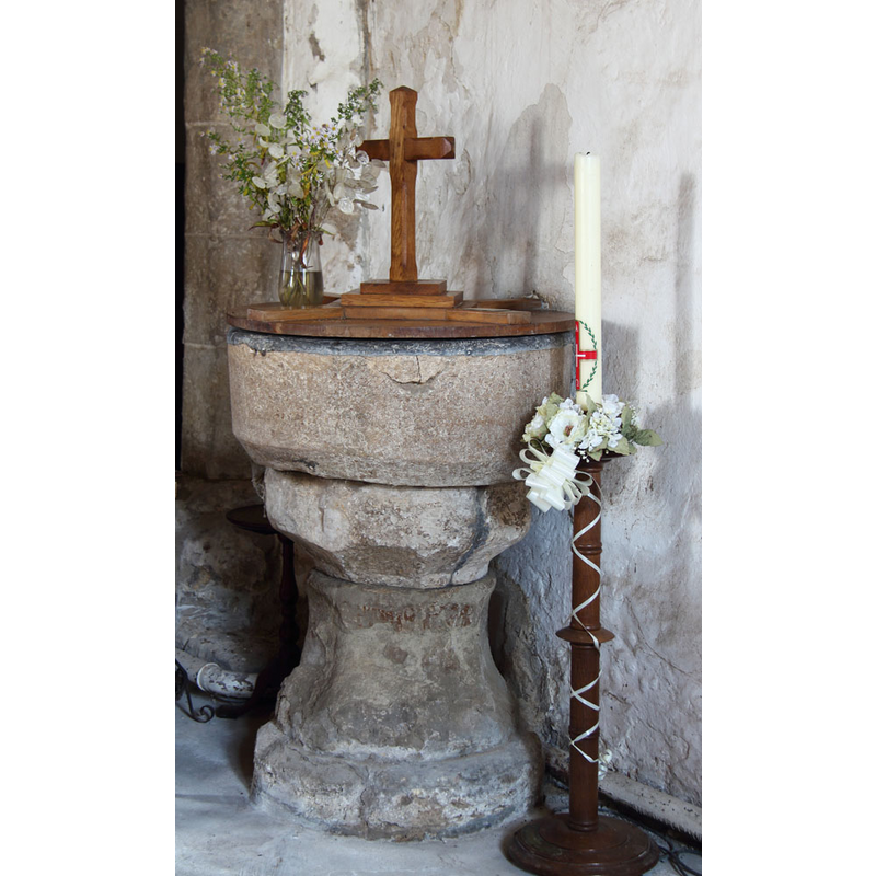
Image copyright © John Salmon, 2014
CC-BY-SA-2.0
Results: 4 records
view of font and cover
Copyright Statement: Image copyright © John Salmon, 2014
Image Source: digital photograph taken 9 October 2014 by John Salmon [www.geograph.org.uk/photo/4212421] [accessed 30 June 2016]
Copyright Instructions: CC-BY-SA-2.0
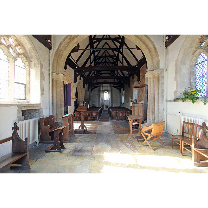
view of church exterior - south view
![EXT S digital photograph taken 9 October 2014 by John Salmon [www.geograph.org.uk/photo/4212384] [accessed 30 June 2016]
INT E digital photograph taken 9 October 2014 by John Salmon [www.geograph.org.uk/photo/4212394] [accessed 30 June 2016]
NT W digital photograph taken 9 October 2014 by John Salmon [www.geograph.org.uk/photo/4212406] [accessed 30 June 2016]
FONT digital photograph taken 9 October 2014 by John Salmon [www.geograph.org.uk/photo/4212421] [accessed 30 June 2016]](/static-50478a99ec6f36a15d6234548c59f63da52304e5/compressed/1160701032_compressed.png)
Scene Description: EXT S digital photograph taken 9 October 2014 by John Salmon [www.geograph.org.uk/photo/4212384] [accessed 30 June 2016]
INT E digital photograph taken 9 October 2014 by John Salmon [www.geograph.org.uk/photo/4212394] [accessed 30 June 2016]
NT W digital photograph taken 9 October 2014 by John Salmon [www.geograph.org.uk/photo/4212406] [accessed 30 June 2016]
FONT digital photograph taken 9 October 2014 by John Salmon [www.geograph.org.uk/photo/4212421] [accessed 30 June 2016]
Copyright Statement: Image copyright © John Salmon, 2014
Image Source: digital photograph taken 9 October 2014 by John Salmon [www.geograph.org.uk/photo/4212384] [accessed 30 June 2016]
Copyright Instructions: CC-BY-SA-2.0
view of church interior - nave - looking west
Copyright Statement: Image copyright © John Salmon, 2014
Image Source: digital photograph taken 9 October 2014 by John Salmon [www.geograph.org.uk/photo/4212406] [accessed 30 June 2016]
Copyright Instructions: CC-BY-SA-2.0
view of church interior - nave - looking east
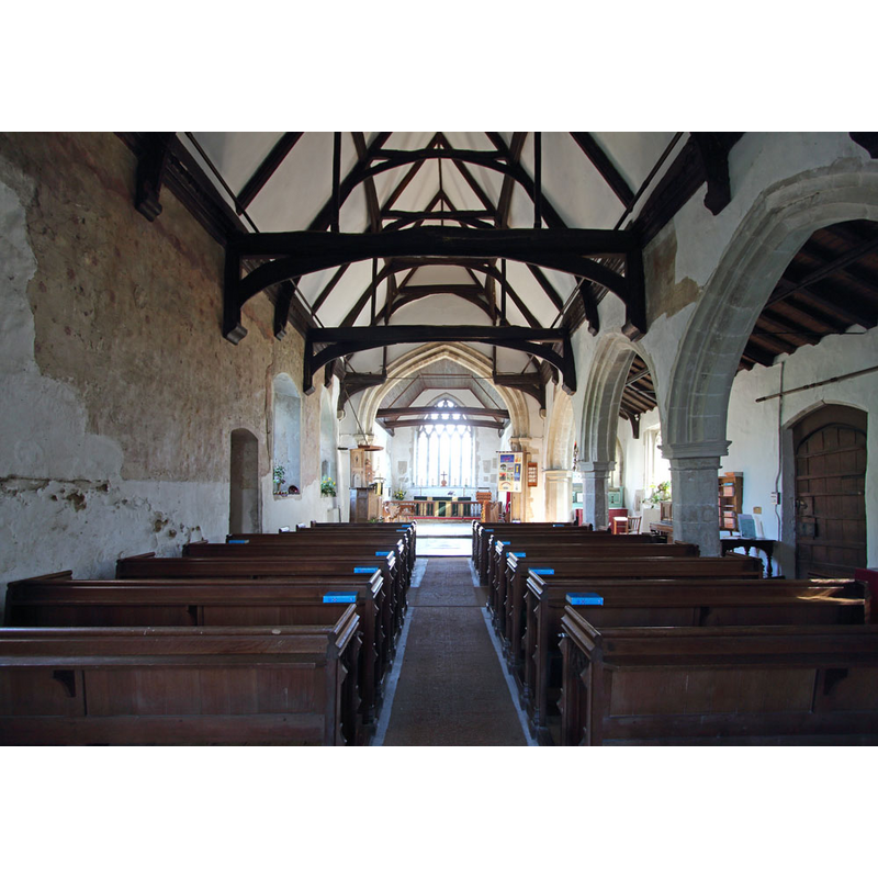
Copyright Statement: Image copyright © John Salmon, 2014
Image Source: digital photograph taken 9 October 2014 by John Salmon [www.geograph.org.uk/photo/4212394] [accessed 30 June 2016]
Copyright Instructions: CC-BY-SA-2.0
INFORMATION
Font ID: 05532RAM
Object Type: Baptismal Font1
Font Century and Period/Style: 12th century [basin only] -- 15th century [base only] [composite font], Medieval / composite
Cognate Fonts: The font at Barton (Cambs.)
Church / Chapel Name: Parish Church of All Saints
Font Location in Church: Inside the church, adjoining the belfry arch
Church Patron Saint(s): All Saints
Church Address: Church End, Rampton, Cambridgeshire CB4 8QA
Site Location: Cambridgeshire, East, England, United Kingdom
Directions to Site: Located about 10 km N of Cambridge, E of the B1049 (access via Cottenham) [NB: not to be mistaken with the Rampton in Nottinghamshire, also with a church dedicated to All Saints and a Norman font of its own]
Ecclesiastic Region: Diocese of Ely
Historical Region: Hundred of Northstowe
Additional Comments: recycled font? / composite font?: [cf. FontNotes]) / painted font? (traces of reddish paint on the base sides
Font Notes:
Click to view
There is an entry for this Rampton [variant spelling] in the Domesday survey [http://opendomesday.org/place/TL4268/rampton/] [accessed 30 June 2016], but it mentions neither cleric nor church in it. Paley (1844) mentions it as one of several fonts built closely adjoining the belfry arch, "and evidently placed there when the arch was built". Paley's Guide of the same year notes "the font, a plain circular basin" near the Perpendicular belfry arch, but pointing our the late-Norman date of other parts of the church, a period to which the original font and the surviving basin are likely to belong. Also in Bond (1908), after Paley. The entry for this church in English Heritage [Listing NGR: TL4285268111] (1962) reports: "The font is C12. Limestone, round basin on octagonal stem." The Victoria County History (Cambridge…, vol. 9, 1989) notes: "The church was included in Picot the sheriff's foundation grant of c. 1092 to the Austin canons of Cambridge, later Barnwell priory, together with two thirds of his undertenant's demesne tithes. […] The thatched nave roof is one of only two surviving in Cambridgeshire. Evidence for a 12th-century building comprising nave and chancel exists in the three-shafted jambs and scalloped capitals of the chancel arch, in a blocked round-headed window in the north wall of the nave, and in chevron voussoirs re-used in the east wall. The unbuttressed tower, which has slim lancets in its second stage, was begun in the later 12th or the 13th century"; there is no mention of a font in the VCH entry.
Stockner (1997) gives 12th-13th century dating and lists it as as a possible early font bowl set within base of successor.
Stockner (1997) gives 12th-13th century dating and lists it as as a possible early font bowl set within base of successor.
COORDINATES
UTM: 31U 301425 5797672
Latitude & Longitude (Decimal): 52.293456, 0.088053
Latitude & Longitude (DMS): 52° 17′ 36.44″ N, 0° 5′ 16.99″ E
MEDIUM AND MEASUREMENTS
Material: stone
Font Shape: cylindrical, mounted
Basin Interior Shape: round
Basin Exterior Shape: round
LID INFORMATION
Date: modern
Material: wood, oak?
Apparatus: no
Notes: rouns and flat, with standing Latin cross; modern
REFERENCES
- Victoria County History [online], University of London, 1993-. URL: https://www.british-history.ac.uk.
- Bond, Francis, Fonts and Font Covers, London: Waterstone, 1985 c1908, p. 89
- Paley, Frederick Apthorp, Illustrations of Baptismal Fonts, London, UK: John van Voorst, 1844, p. 11
- Paley, Frederick Apthorp, The Ecclesiologist's guide to the churches within a circuit of seven miles round Cambridge, with introductory remarks, London; Cambridge: J. van Voorst; Metcalfe and Palmer, 1844, p. 11
- Stocker, D.A., "Fons et origo: The Symbolic Death and Resurrection of English Font Stones", I (1997b), Church Archaeology, 1997, pp. 17-25; p. 20ff, 24