Old Malden / Malden / Maldone / Melden / Meldone
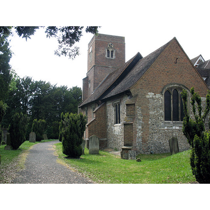
Image copyright © Stephen Craven, 2008
CC-BY-SA-2.0
Results: 4 records
view of church exterior - southeast view
Scene Description: Source caption: "St John's, Old Malden. The part of the church nearest the camera in this view is the mediaeval lady chapel, with the 17th century nave and tower beyond [...] The medieval church was built by Walter de Merton, founder of Merton College, Oxford who are still patrons of the living and own adjacent properties."
Copyright Statement: Image copyright © Stephen Craven, 2008
Image Source: digital photograph taken 22 May 2008 by Stephen Craven [www.geograph.org.uk/photo/812243] [accessed 21 December 2015]
Copyright Instructions: CC-BY-SA-2.0
view of church exterior - east view
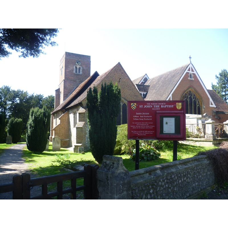
Scene Description: Source caption: "St John’s Church, Old Malden. Here are to be found the remnants of the old village of Malden, consisting of St John’s Church, the Manor House and Manor Farm. The flintwork of the chancel is medieval. The rest of the church is early 17th century. In 1875, a new nave and chancel were built, reducing the previous nave and chancel (seen here on the left) to a south aisle and south chapel."
Copyright Statement: Image copyright © Marathon, 2013
Image Source: digital photograph taken 1 May 2013 by Marathon [www.geograph.org.uk/photo/3440442] [accessed 21 December 2015]
Copyright Instructions: CC-BY-SA-2.0
view of church exterior
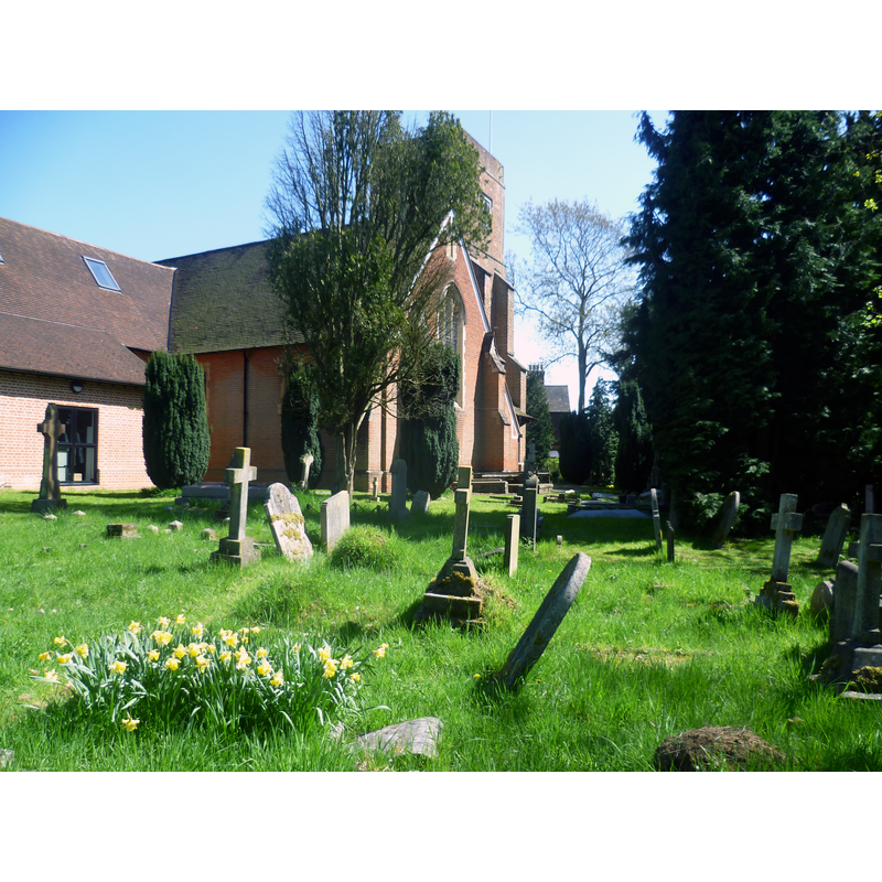
Scene Description: Source caption: "In the churchyard of St John’s, Old Malden. Here are to be found the remnants of the old village of Malden, consisting of St John’s Church, the Manor House and Manor Farm. The flintwork of the chancel is medieval. The rest of the church is early 17th century. In 1875, a new nave and chancel were built (seen here in front of the tower), reducing the previous nave and chancel to a south aisle and south chapel."
Copyright Statement: Image copyright © Marathon, 2013
Image Source: digital photograph taken 1 May 2013 by Marathon [www.geograph.org.uk/photo/3440451] [accessed 21 December 2015]
Copyright Instructions: CC-BY-SA-2.0
view of church interior - nave - looking east
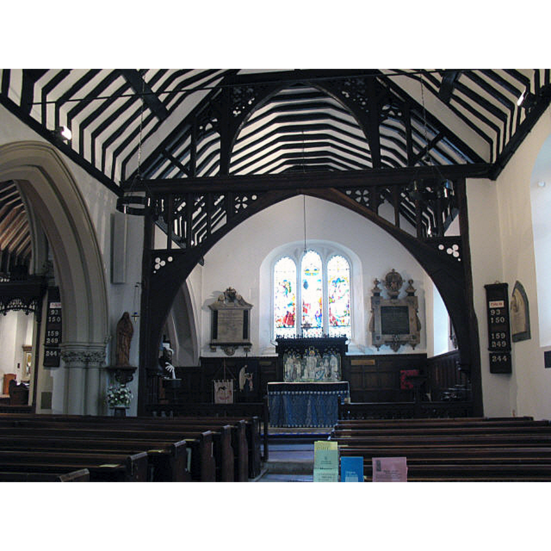
Scene Description: Source caption: "Interior of St John's church. An interior view of the 17th century nave (restored 1863) and mediaeval lady chapel"
Copyright Statement: Image copyright © Stephen Craven, 2008
Image Source: digital photograph taken 22 May 2008 by Stephen Craven [www.geograph.org.uk/photo/812252] [accessed 21 December 2015]
Copyright Instructions: CC-BY-SA-2.0
INFORMATION
Font ID: 05467MAL
Object Type: Baptismal Font1?
Font Century and Period/Style: 12th - 14th century / 17th century, Medieval? / Post-Reformation?
Church / Chapel Name: Parish Church of St. John the Baptist
Font Location in Church: [cf. FontNotes]
Church Patron Saint(s): St. John the Baptist
Church Address: Church Rd, Worcester Park, Surrey KT4 7RY, United Kingdom -- Tel.: +44 20 8330 2817
Site Location: Greater London, South East, England, United Kingdom
Directions to Site: Located in the Royal Borough of Kingston-upon-Thames, 5 km SE of Kingston, 16 km SW of Charing Cross
Ecclesiastic Region: Diocese of Southwark
Historical Region: Hundred of Kingston -- formerly in Surrey
Additional Comments: disappeared font? (the one from the Domesday-time church here)
Font Notes:
Click to view
There are three entries for Malden [variant spelling] in the Domesday survey [http://opendomesday.org/place/TQ2166/malden/] [accessed 21 December 2015], one of which mentions a church in it. Brayley (1850) reports: "The font is a large stone basin for immersion, standing upon a low octagonal block of freestone." [NB: Bond (1908) lists one of several "well meant fonts put up between the Reformation and the Rebellion" in Malden [but not clear which Malden it is]]. The Victoria County History (Surrey, vol. 3, 1911) notes: "A chapel or church existed in Malden at the time of the Domesday Survey, (fn. 21) and was then included in the property of Robert de Watevile. It was granted by Eudo de Malden before 1189 to the priory of Merton. [...] The nave and chancel were erected in 1875, before which year the present south chapel was the chancel and the aisle the nave. It is recorded that the nave and tower were built in 1610, but it is probable that the chancel, which leans to the north, was erected at least a century earlier. [...] All the fittings are modern; the font has a marble bowl on a stone stem."
COORDINATES
UTM: 30U 690580 5695860
Latitude & Longitude (Decimal): 51.38194, -0.26124
Latitude & Longitude (DMS): 51° 22′ 54.98″ N, 0° 15′ 40.46″ W
MEDIUM AND MEASUREMENTS
Material: stone
REFERENCES
- Victoria County History [online], University of London, 1993-. URL: https://www.british-history.ac.uk.
- Bond, Francis, Fonts and Font Covers, London: Waterstone, 1985 c1908, p. 265
- Brayley, Edward Wedlake, A topographical history of Surrey, London: G. Willis, 1850, vol. 3: 165