Hemingbrough / Haamburg? / Haaniburg? / Hamiburg? / Hemingborough
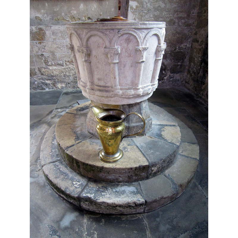
Image copyright © Hazel Pickering,2018
Permission received from the author (e-mail of 25 November 2018)
Results: 11 records
view of font and cover
Copyright Statement: Image copyright © Hazel Pickering,2018
Image Source: digital photograph 12 July 2015 in Pickerings of Yorkshire [www.pickeringsofyorkshire.com/east-riding/parishes-g-h/hemingbrough] [accessed 17 November 2018]
Copyright Instructions: Permission received from the author (e-mail of 25 November 2018)
view of font
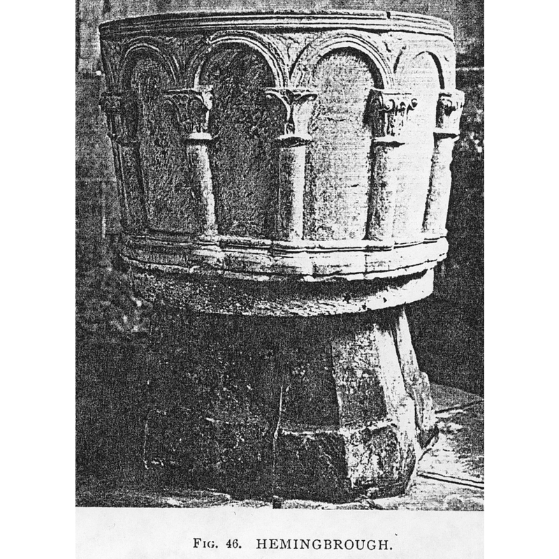
Copyright Statement: Image copyright © [in the public domain]
Image Source: Tyrrell-Green (1928: fig. 46)
Copyright Instructions: PD
design element - motifs - varied
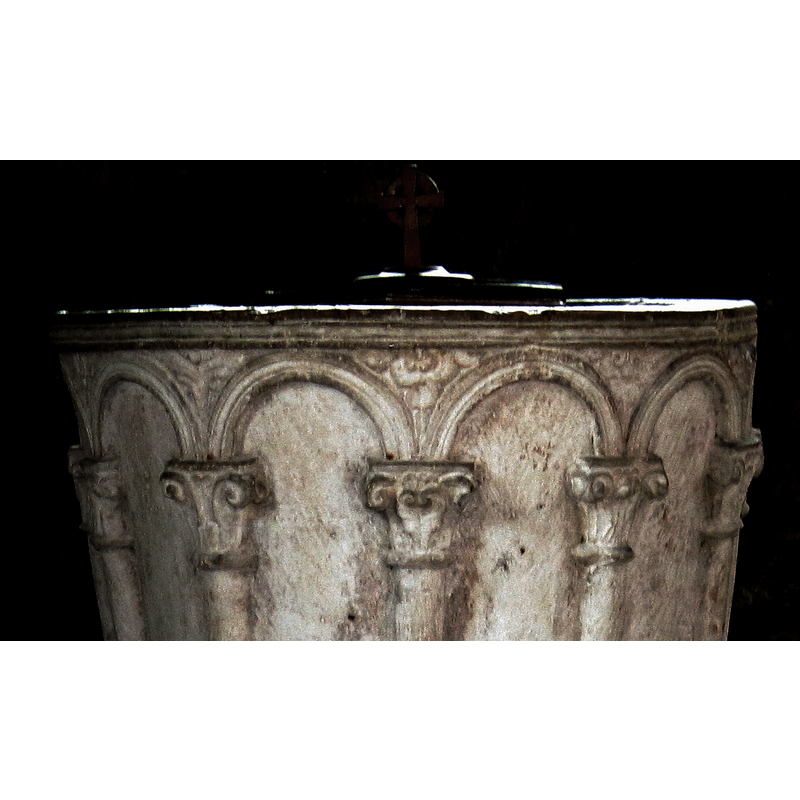
Scene Description: only a dew of the original motifs in the spandrels of the arcade remain; of those, most appear to be floral or foliate
Copyright Statement: Image copyright © Martin Dawes, 2014
Image Source: edited detail of a digital photograph taken 19 February 2014 by Martin Dawes [www.geograph.org.uk/photo/3900154] [accessed 17 November 2018]
Copyright Instructions: CC-BY-SA-2.0
design element - motifs - moulding
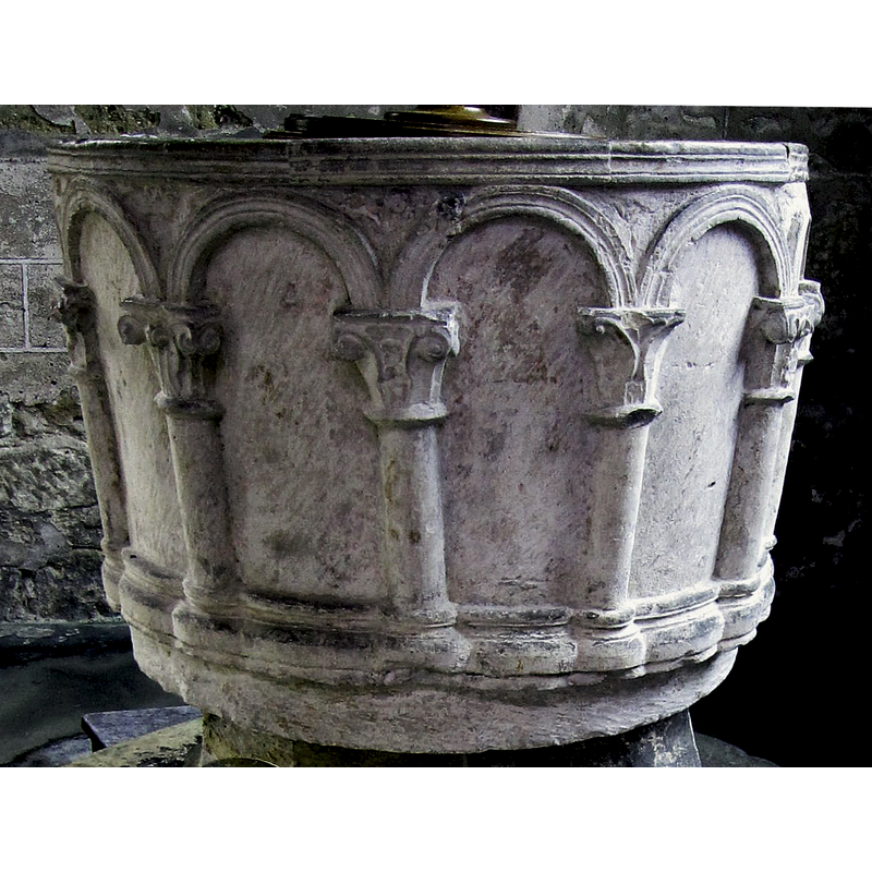
Scene Description: all around the upper rim sides
Copyright Statement: Image copyright © Hazel Pickering,2018
Image Source: edited detail of a digital photograph 12 July 2015 in Pickerings of Yorkshire [www.pickeringsofyorkshire.com/east-riding/parishes-g-h/hemingbrough] [accessed 17 November 2018]
Copyright Instructions: Permission received from the author (e-mail of 25 November 2018)
design element - architectural - arcade - blind - round arches - columns with capitals and bases - water-leaf capital
Scene Description: all around the basin sides
Copyright Statement: Image copyright © Hazel Pickering,2018
Image Source: edited detail of a digital photograph 12 July 2015 in Pickerings of Yorkshire [www.pickeringsofyorkshire.com/east-riding/parishes-g-h/hemingbrough] [accessed 17 November 2018]
Copyright Instructions: Permission received from the author (e-mail of 25 November 2018)
view of church exterior - south view
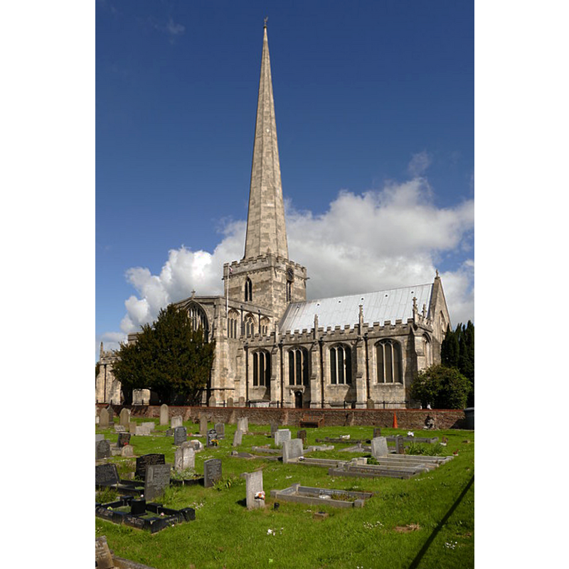
Scene Description: Source caption: "The Collegiate Church of St Mary the Virgin. A grade I listed building dating from the 12th century."
Copyright Statement: Image copyright © Graham Hogg, 2015
Image Source: digital photograph taken 28 May 2015 by Graham Hogg [www.geograph.org.uk/photo/4503323] [accessed 17 November 2018]
Copyright Instructions: CC-BY-SA-2.0
view of church exterior in context - south view
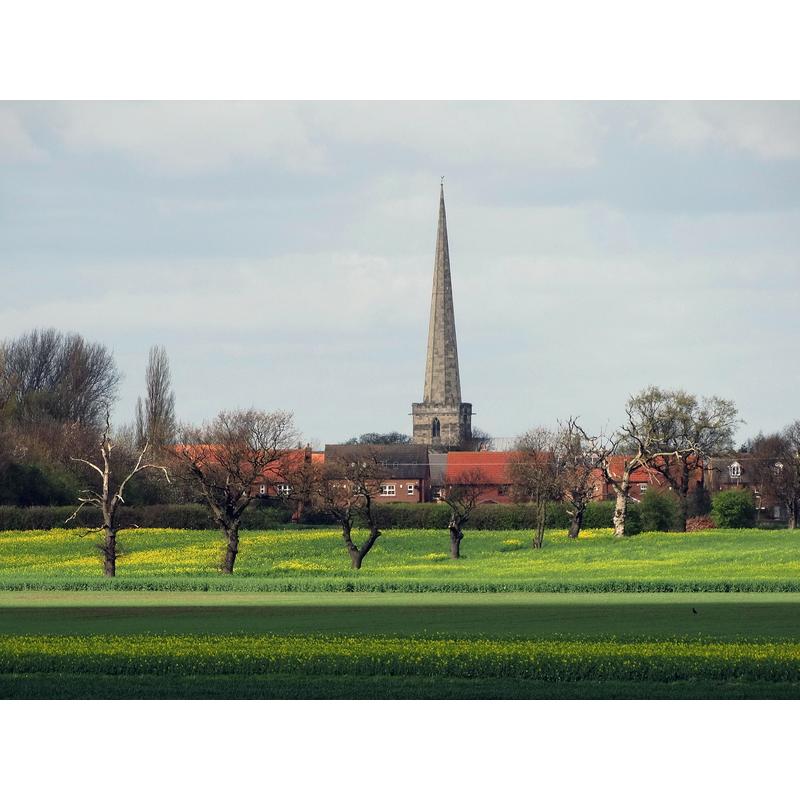
Copyright Statement: Image copyright © Neil Theasby, 2014
Image Source: digital photograph taken 8 April 2014 by Neil Theasby [www.geograph.org.uk/photo/3921778] [accessed 17 November 2018]
Copyright Instructions: CC-BY-SA-2.0
view of basin - south-southwest side - detail

Scene Description: two of the lovely water-leaf capitals
Copyright Statement: Image copyright © CRSBI, 2018
Image Source: digital image of a B&W photograph from the CRSBI, in VAD [https://vads.ac.uk/images/CRSBI/large/w17820.jpg] [accessed 17 November 2018
Copyright Instructions: no access to this image in the CRSBI entry for the church / accessible only in VADS / assumed usual CRSBI copyright restriction -- PERMISSION NOT AVAILABLE -- IMAGE NOT FOR PUBLIC USE
view of basin - south-southwest side
Scene Description: detail of the arcade
Copyright Statement: Image copyright © CRSBI, 2018
Image Source: digital image of a B&W photograph from the CRSBI, in VAD [https://vads.ac.uk/images/CRSBI/large/w17819.jpg] [accessed 17 November 2018
Copyright Instructions: no access to this image in the CRSBI entry for the church / accessible only in VADS / assumed usual CRSBI copyright restriction -- PERMISSION NOT AVAILABLE -- IMAGE NOT FOR PUBLIC USE
view of basin - southwest side
Copyright Statement: Image copyright © CRSBI, 2018
Image Source: digital image of a B&W photograph from the CRSBI, in VAD [https://vads.ac.uk/images/CRSBI/large/w17815.jpg] [accessed 17 November 2018
Copyright Instructions: no access to this image in the CRSBI entry for the church / accessible only in VADS / assumed usual CRSBI copyright restriction -- PERMISSION NOT AVAILABLE -- IMAGE NOT FOR PUBLIC USE
view of basin - west side
Copyright Statement: Image copyright © CRSBI, 2018
Image Source: digital image of a B&W photograph from the CRSBI, in VAD [https://vads.ac.uk/images/CRSBI/large/w17816.jpg] [accessed 17 November 2018
Copyright Instructions: no access to this image in the CRSBI entry for the church / accessible only in VADS / assumed usual CRSBI copyright restriction -- PERMISSION NOT AVAILABLE -- IMAGE NOT FOR PUBLIC USE
INFORMATION
Font ID: 05314HEM
Object Type: Baptismal Font1
Font Date: ca. 1200?
Font Century and Period/Style: 12th century (late?), Late Norman? / Transitional?
Cognate Fonts: resembles the font at York St. Helen's
Church / Chapel Name: Parish Church of St. Mary the Virgin [aka Hemingbrough Minster]
Font Location in Church: Inside the church, W end of the south aisle
Church Patron Saint(s): St. Mary the Virgin
Church Address: Main Street, Hemingbrough, Selby YO8 6QE, UK -- Tel.: 01757 706288
Site Location: North Yorkshire, Yorkshire and the Humber, England, United Kingdom
Directions to Site: Located off the A63, 8 km SE of Selby, 20 km ESE of York
Ecclesiastic Region: Diocese of York
Historical Region: Hundred of Howden
Additional Comments: altered font? [cf. FontNotes]
Font Notes:
Click to view
There is an entry for Hemingbrough [variant spelling] in the Domesday survey [https://opendomesday.org/place/SE6730/hemingbrough/] [accessed 17 November 2018]; ir reports a priest and a church in it. Glynne's 5 April 1825 visit to this church (in Butler, 2007) reports: "The font stands in the western portion of the nave, and is an elegant Norman specimen, being large and round, and moulded with a range of semi-circular arches. It resembles that in St. Helen's Church in York." Bulmer's Directory of East Yorkshire (1892) writes: "The font is co-eval with the Norman church and is in good preservation" [2002 transcription by Colin Hinson in www.genuki.org.uk]. Mentioned in Bond (1908: 149n) simply as a font with water-leaf capitals. Described and illustrated in Tyrrell-Green (1928) as a mounted bucket-shaped font of the Norman period; the sides of the basin are ornamented with a blind arcade of round arches supported on beautiful water-leaf capitals. The base is polygon, as if it did not belong to this basin. The Victoria County History (York East Riding, vol. 3, 1976) notes the entry reported in the Domesday survey and dates the baptismal font here to ca. 1200. The entry for this church in Historic England [Listing NGR: SE6735830619] notes: "Church. Late C12 origins to nave and north transept with C13, C14 and C15 additions; late C13 chancel with C15 south chapel and upper stage to north chapel; late C13 south transept with C15 additions; late C13 tower with spire of c1416-1446. […] Arcaded tub font of c1200." The entry for this church in the CRSBI (2018) notes the font: "Font. Now placed at the W end of the S aisle. The font proper is a cylindrical drum flared slightly outwards to the top. It is set on an octagonal stem; these parts are mounted on a two-step circular plinth. The bottom of the actual font has a plain circular band, indicating that it originally stood on the floor like the early 12thc. Cylindrical fonts in the Riding. Above that plain band, the arcading stands on a continuous moulding, which not only imitates round bases, but rounds the spaces between them. There are 12 bays, so there are 24 scallops. The capitals are individually carved; the arches are similarly moulded except for one, which has a dent; several of the spandrels have ornament of some skill and the top has another moulding. […] With all the finesse of the font, why is it all set out so irregularly? Columns are not at regular distances, and some of them slope. Might this be a late 12thc. Re-fashioning of an earlier arcaded font? Raine, 1888, 22, says 'The work is coarsely and roughly done, although the effect from a distance is fairly good'. This is a good assessment. It is amazingly irregular for a late 12thc. Font. There has been quite a bit of subsequent damage around the rim." [NB: for the Raine ref.: T. Burton, edited and enlarged by J. Raine, The history and antiquities of the parish of Hemingbrough, York 1888.]
Credit and Acknowledgements: We are grateful to Hazel Pickering for her photograph of this font
COORDINATES
UTM: 30U 633140 5959492
Latitude & Longitude (Decimal): 53.767, -0.98
Latitude & Longitude (DMS): 53° 46′ 1.2″ N, 0° 58′ 48″ W
MEDIUM AND MEASUREMENTS
Material: stone
Number of Pieces: two?
Font Shape: bucket-shaped, mounted
Basin Interior Shape: round
Basin Exterior Shape: round
Rim Thickness: 12.25 cm [calculated]
Diameter (inside rim): 58 cm*
Diameter (includes rim): 82.5 cm*
Basin Depth: 37 cm*
Basin Total Height: 59 cm*
Font Height (less Plinth): 94.5 cm*
Notes on Measurements: * CRSBI (2018)
LID INFORMATION
Date: modern
REFERENCES
- Victoria County History [online], University of London, 1993-. URL: https://www.british-history.ac.uk.
- Bond, Francis, Fonts and Font Covers, London: Waterstone, 1985 c1908, p. 149
- Bulmer, T., History and Directory of East Yorkshire, 1892, [page unknown]
- Glynne, Stephen Richard, The Yorkshire notes of Sir Stephen Glynne (1825-1874), Woodbridge: The Boydell Press; Yorkshire Archaeological Society, 2007, p. 216
- Tyrrell-Green, E., Baptismal Fonts Classified and Illustrated, London: Society for Promoting Christian Knowledge: The Macmillan Co., 1928, p. 76 and fig. 46