Bicester / Bernecestre
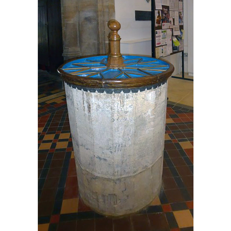
Image copyright © Basher Eyre, 2015
CC-BY-SA-2.0
Results: 5 records
view of font and context
Scene Description: in 2015 the font is seen resting directly on the ground; the two-step plinth is gone
Copyright Statement: Image copyright © Basher Eyre, 2015
Image Source: digital photograph taken 21 September 2015 by Basher Eyre [www.geograph.org.uk/photo/4742935] [accessed 6 December 2016]
Copyright Instructions: CC-BY-SA-2.0
view of font and cover
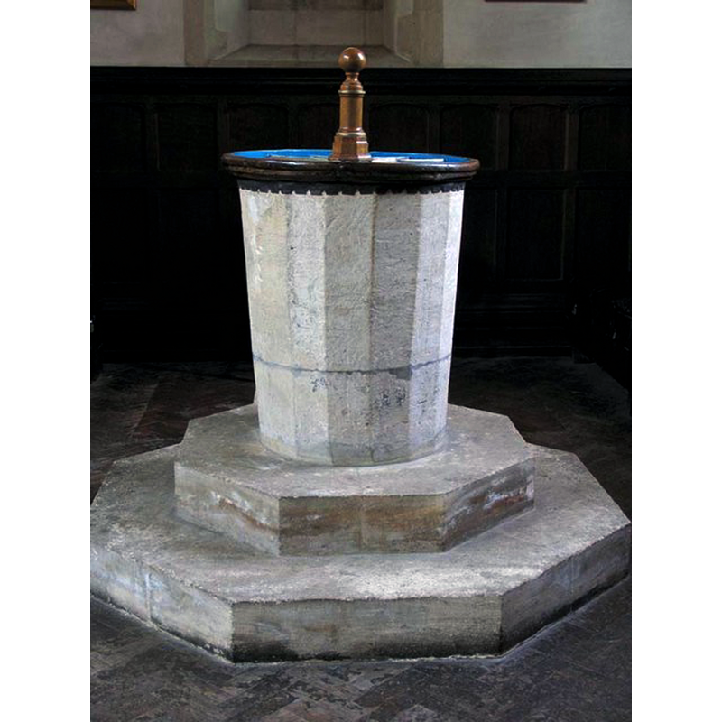
Scene Description: in 2005 the font was raised on a two-step plinth
Copyright Statement: Image copyright © John Salmon, 2009
Image Source: digital photograph taken 11 June 2005 by John Salmon [www.geograph.org.uk/photo/1634505] [accessed 6 December 2016]
Copyright Instructions: CC-BY-SA-2.0
view of church exterior - northwest view
![EXT W digital photograph taken 2 November 2015 by Steve Daniels [www.geograph.org.uk/photo/4735488] [accessed 6 December 2016]
INT E digital photograph taken 11 June 2005 by John Salmon [www.geograph.org.uk/photo/1634519] [accessed 6 December 2016] COPY2009
INT W digital photograph taken 11 June 2005 by John Salmon [www.geograph.org.uk/photo/1634517] [accessed 6 December 2016] COPY2009
FONT digital photograph taken 11 June 2005 by John Salmon [www.geograph.org.uk/photo/1634505] [accessed 6 December 2016] COPY2009
FONT+COVER digital photograph taken 21 September 2015 by Basher Eyre [www.geograph.org.uk/photo/4742935] [accessed 6 December 2016]](/static-50478a99ec6f36a15d6234548c59f63da52304e5/compressed/1161206011_compressed.png)
Scene Description: EXT W digital photograph taken 2 November 2015 by Steve Daniels [www.geograph.org.uk/photo/4735488] [accessed 6 December 2016]
INT E digital photograph taken 11 June 2005 by John Salmon [www.geograph.org.uk/photo/1634519] [accessed 6 December 2016] COPY2009
INT W digital photograph taken 11 June 2005 by John Salmon [www.geograph.org.uk/photo/1634517] [accessed 6 December 2016] COPY2009
FONT digital photograph taken 11 June 2005 by John Salmon [www.geograph.org.uk/photo/1634505] [accessed 6 December 2016] COPY2009
FONT+COVER digital photograph taken 21 September 2015 by Basher Eyre [www.geograph.org.uk/photo/4742935] [accessed 6 December 2016]
Copyright Statement: Image copyright © Steve Daniels, 2015
Image Source: digital photograph taken 2 November 2015 by Steve Daniels [www.geograph.org.uk/photo/4735488] [accessed 6 December 2016]
Copyright Instructions: CC-BY-SA-2.0
view of church interior - nave - looking west
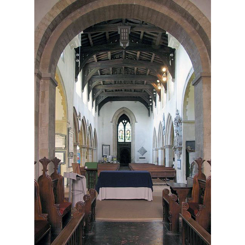
Copyright Statement: Image copyright © John Salmon, 2009
Image Source: digital photograph taken 11 June 2005 by John Salmon [www.geograph.org.uk/photo/1634517] [accessed 6 December 2016]
Copyright Instructions: CC-BY-SA-2.0
view of church interior - nave - looking east
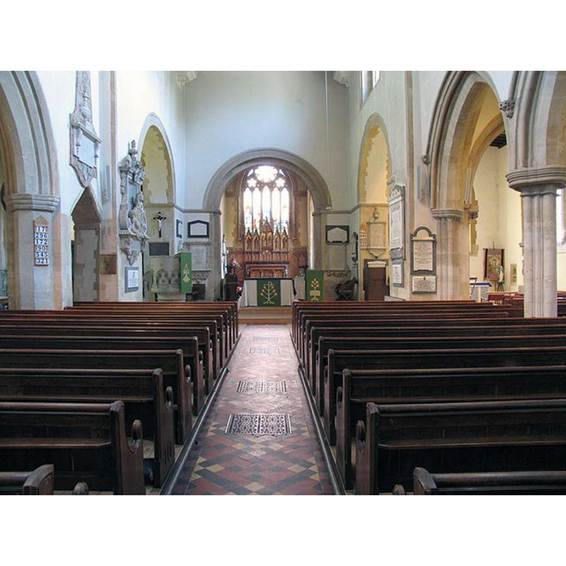
Copyright Statement: Image copyright © John Salmon, 2009
Image Source: digital photograph taken 11 June 2005 by John Salmon [www.geograph.org.uk/photo/1634519] [accessed 6 December 2016]
Copyright Instructions: CC-BY-SA-2.0
INFORMATION
Font ID: 05204BIC
Object Type: Baptismal Font1
Font Century and Period/Style: 13th century, Early English
Church / Chapel Name: Parish Church of St. Eadburg [aka St Edburg's]
Font Location in Church: In the nave [cf. FontNotes]
Church Patron Saint(s): St. Edburga of Winchester [aka Eadburga, Eadburgh, Eadburh, Edburg]
Church Address: 8 Church Street, Bicester OX26 6AZ
Site Location: Oxfordshire, South East, England, United Kingdom
Directions to Site: Located about 25 km WNW of Oxford, on the A34/A41/A421
Ecclesiastic Region: Diocese of Oxford
Historical Region: Hundred of Kirtlington [in Domesday] -- Hundred of Ploughley
Additional Comments: altered font (2005 on a plinth; 2015 no plinth)
Font Notes:
Click to view
There is an entry for Bicester [variant spelling] in the Domesday survey [http://opendomesday.org/place/SP5822/bicester/] [accessed 6 December 2016], but it mentions neither cleric nor church in it. The Guide to the Architectural Antiquities in the Neighbourhood of Oxford (1846) reports a font "plain, polygonal, probably Early English". The Victoria County History (Oxford, vol. 6, 1959) notes: "The tradition that the church dated from the 7th century may be exaggerated, and the architectural evidence for a late Saxon building cannot be accepted without question. [...] That there was a church before the Conquest cannot, however, be doubted, and like the town it probably belonged to Wigod of Wallingford and after him to Robert d'Oilly. [...] The church's early importance is indicated by its relations with the dependent chapels of Stratton and Launton, and particularly with the latter. [...] Moreover, by the end of the 12th century at latest Bicester had given its name to a deanery comprising 33 churches. [...] Soon after 1182 Gilbert Basset, then lord of Bicester and Stratton, gave the church with its dependent chapel at Stratton to his newly founded priory of Austin canons at Bicester [...] At the end of the century, during the incumbency of Thomas Shewring (1691–6), a faculty was sought for 'erecting' a vestry (16 ft. by 16 ft.) and for the removal of the font. [...] The font, a plain polygonal one, probably dates from the 13th century. Early in the 20th century it was raised on two steps and the baptistery was panelled in oak in memory of the Revd. G. P. Crawfurd (vicar 1894–1907) and of his family." [NB: a footnote to the previous text in the VCH (ibid.) reads: "G. P. Crawfurd, Recollections (Reading), 84. For an illustration of the font see Dunkin, Oxon. ii, between pp. 252–3"]. The font is mentioned in Kelly's Oxford Directory of 1911 [http://www.historicaldirectories.org/hd/d.asp] [accessed 30 June 2007]: "the font is plain and polygonal, expanding towards the top and is probably Early English". In Sherwood & Pevsner (1974): "Polygonal and plain; C13?". [NB: In 2005 the font was raised on a two-step plinth; by 2015 the plinth had been removed and the font was resting directly on the ground].
COORDINATES
UTM: 30U 626997 5751024
Latitude & Longitude (Decimal): 51.895489, -1.154313
Latitude & Longitude (DMS): 51° 53′ 43.76″ N, 1° 9′ 15.53″ W
MEDIUM AND MEASUREMENTS
Material: stone
Font Shape: polygonal
Basin Exterior Shape: polygonal
LID INFORMATION
Date: 18th century?
Material: wood, oak?
Apparatus: no
Notes: round platform carved and coloured (blue); turned handle-finial; 18thC
REFERENCES
- Victoria County History [online], University of London, 1993-. URL: https://www.british-history.ac.uk.
- Kelly, Kelly's Directory of Oxfordshire, London: Kelly's Directories Ltd., 1911, p. 46
- Oxford Society for Promoting the Study of Gothic Architecture, Guide to the Architectural Antiquities in the Neighbourhood of Oxford, A, Oxford: John Henry Parker [for the Society], 1846, p. 25
- Pevsner, Nikolaus, Oxfordshire, Harmondsworth: Penguin Books, 1974, p. 453