Brinklow
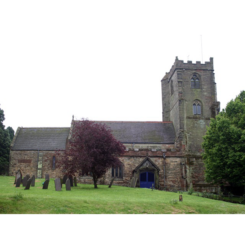
Image copyright © Hugh Craddock, 2008
CC-BY-SA-2.0
Results: 2 records
view of church exterior - north view
Copyright Statement: Image copyright © Hugh Craddock, 2008
Image Source: digital photograph taken 21 May 2008 by Hugh Craddock [www.geograph.org.uk/photo/826679] [accessed 27 January 2015]
Copyright Instructions: CC-BY-SA-2.0
design element - motifs - floral - in a circle
![paterae [cf. Font notes]](/static-50478a99ec6f36a15d6234548c59f63da52304e5/others/image_not_available.jpg)
Scene Description: paterae [cf. Font notes]
![paterae [cf. Font notes]](/static-50478a99ec6f36a15d6234548c59f63da52304e5/bsi-testing-site/others/image_not_available.jpg)
INFORMATION
Font ID: 05154BRI
Object Type: Baptismal Font1
Font Century and Period/Style: 16th century(early?) [re-tooled], Perpendicular [altered?]
Church / Chapel Name: Parish Church of St. John the Baptist [originally a chapel of Smite]
Font Location in Church: Inside the church, built into the W side of the N arcade pillar opposite the N entrance
Church Patron Saint(s): St. John the Baptist
Church Address: Broad Street, Brinklow, Warwickshire, CV23 0LQ
Site Location: Warwickshire, West Midlands, England, United Kingdom
Directions to Site: Located on the B4027 [aka Lutterworth Road], 11 km E of Coventry
Ecclesiastic Region: Diocese of Coventry
Historical Region: Hundred of Brinklow -- Hundred of Knightlow
Additional Comments: altered font? (the present font) -- disappeared font? (the one from the 12thC (?) chapel/church here)
Font Notes:
Click to view
No entry for Brinklow found in the Domesday survey, but, according to Dugdale [quoted in the VCH entry below], it was included with Smite, itself now disappeared. Bond (1908) quotes a churchwarden's account from the parish register at Brinklow for the year 1653: "bought a bassin to cristen the children which cost three shilling sixpence" [it was surely the "bassin" that cost three and six, not the children]. [NB: this 'bassin', introduced in the Puritan spirit of the Commonwealth, would have been as plain and simple as possible, and probably discarded during the Restoration]. The Victoria County History (Warwick, vol. 6, 1951) notes: "Brinklow was originally a chapelry of Smite, and was granted with the parent church, in the reign of Henry I [i.e., 1100-1135], by Samson de Albenei with the consent of Roger de Mowbray to the priory of Kenilworth [...] The parish church [...] was rebuilt about the end of the 15th century and all that remains of the earlier church is the chancel, parts of the north aisle walls and possibly the staircase to the roodloft. [...] The font, with a lead-lined basin, is built into the west side of the north arcade pillar opposite the door. It is of stone, with an octagonal moulded basin with paterae, and octagonal stem and base which has been rendered in cement. It has been re-dressed but is probably contemporary with the arcade" [i.e., "probably early-16th century" (VCH., ibid.)] [NB: this church has a north porch and entrance, and the font, built into the second pillar from the west, is in a straight north-south line with the entranceway]. In Pevsner & Wedgwood (2000 c1966) as an octagonal font decorated with fleurons, possibly Perpendicular.
COORDINATES
UTM: 30U 611421 5807801
Latitude & Longitude (Decimal): 52.409082, -1.361952
Latitude & Longitude (DMS): 52° 24′ 32.69″ N, 1° 21′ 43.03″ W
MEDIUM AND MEASUREMENTS
Material: stone
Font Shape: octagonal, mounted
Basin Interior Shape: round
Basin Exterior Shape: octagonal
Drainage Notes: lead-lined
REFERENCES
- Victoria County History [online], University of London, 1993-. URL: https://www.british-history.ac.uk.
- Bond, Francis, Fonts and Font Covers, London: Waterstone, 1985 c1908, p. 36
- Pevsner, Nikolaus, Warwickshire, Harmondsworth: Penguin, 2000 [c1966], p. 218