Brailes / Lower Brailes
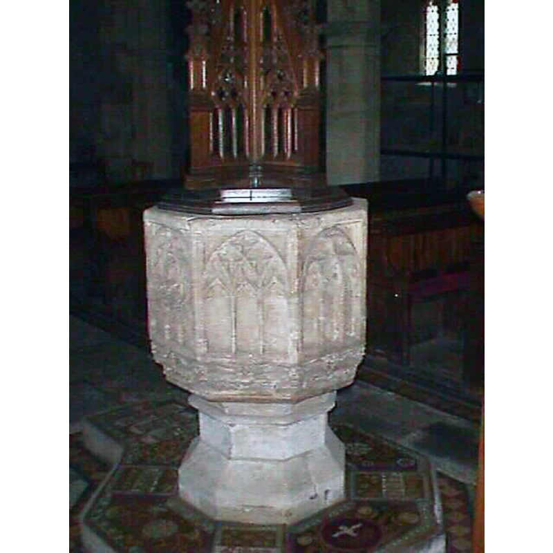
Image copyright © John Wilkes, 2006
Image and permission received (e-mail of 17 March 2006)
Results: 9 records
view of font and cover
Copyright Statement: Image copyright © John Wilkes, 2006
Image Source: digital photograph by John Wilkes [www.althecotswolds.com]
Copyright Instructions: Image and permission received (e-mail of 17 March 2006)
view of font
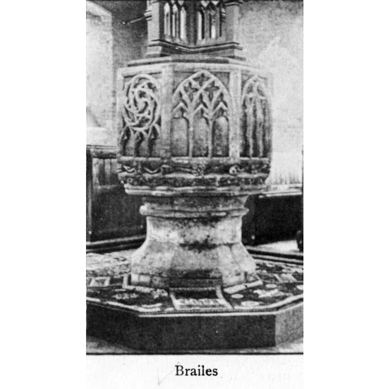
Copyright Statement: Image copyright © [in the public domain]
Image Source: B&W photograph in Bond (1908)
Copyright Instructions: PD
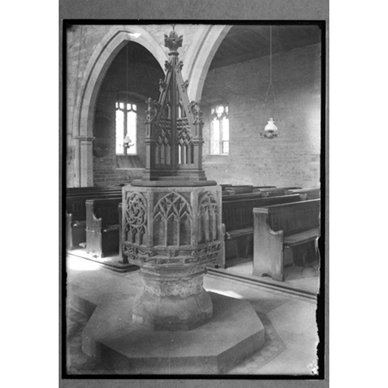
view of font
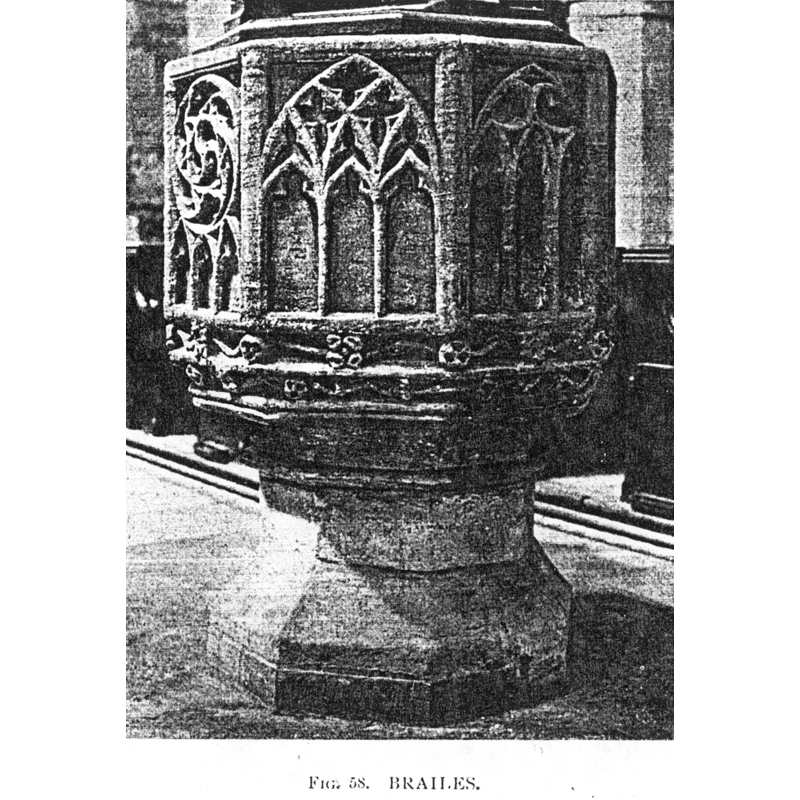
Copyright Statement: Image copyright © [in the public domain]
Image Source: B&W photograph in Tyrrell-Green (1928)
Copyright Instructions: PD
design element - patterns - tracery
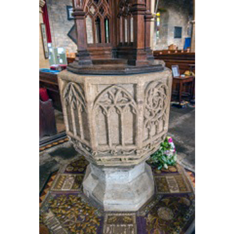
Scene Description: assorted; each panel has a differente pattern
Copyright Statement: Image copyright © David Ross & Britain Express Ltd, 2014
Image Source: digital photograph taken by David Ross [www.britainexpress.com/counties/warwickshire/churches/lower-brailes.htm] [accessed 19 December 2014]
Copyright Instructions: Standing permission
design element - motifs - foliage
Scene Description: in two bands, around the underbowl
Copyright Statement: Image copyright © David Ross & Britain Express Ltd, 2014
Image Source: digital photograph taken by David Ross [www.britainexpress.com/counties/warwickshire/churches/lower-brailes.htm] [accessed 19 December 2014]
Copyright Instructions: Standing permission
view of church exterior - southwest view
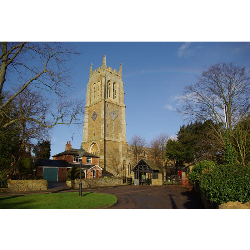
Scene Description: Source caption: "Lower Brailes Church. This imposing church,dedicated to St George, is sometimes referred to as the 'Cathedral of the Feldon'. The Feldon is a name given to the southern part of Warwickshire where the countryside was historically more open than the Forest of Arden in the north."
Copyright Statement: Image copyright © Stephen McKay, 2007
Image Source: digital photograph taken 21 January 2007 by Stephen McKay [www.geograph.org.uk/photo/317838] [accessed 19 December 2014]
Copyright Instructions: CC-BY-SA-2.0
view of church interior - nave - looking east
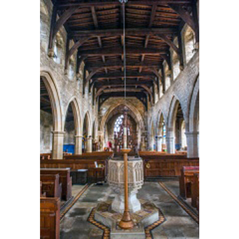
Scene Description: with the font in the foreground
Copyright Statement: Image copyright © David Ross & Britain Express Ltd, 2014
Image Source: digital photograph taken by David Ross [www.britainexpress.com/counties/warwickshire/churches/lower-brailes.htm] [accessed 19 December 2014]
Copyright Instructions: Standing permission
view of font and cover in context
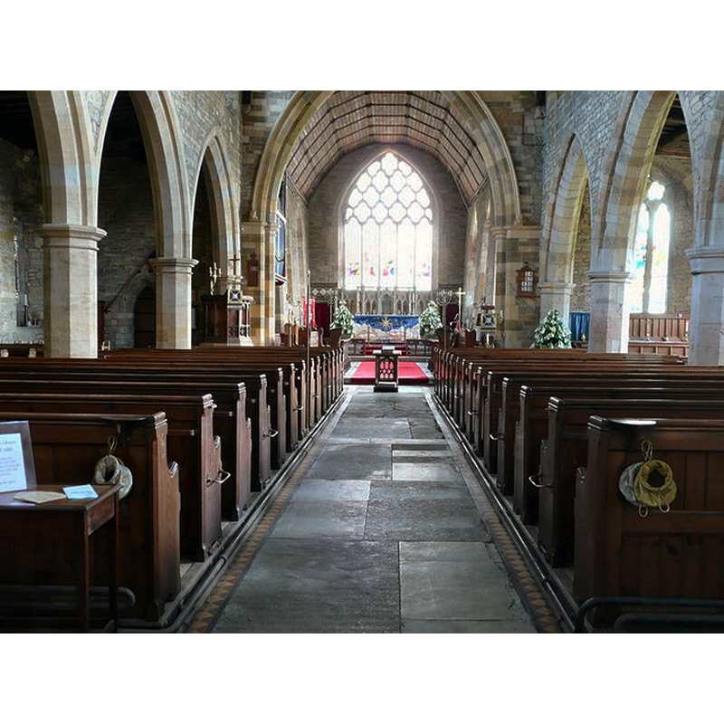
Scene Description: Source caption: "Brailes (Upper and Lower) is an attractive village surrounded by hills at the southern extremity of Warwickshire, bordering Oxfordshire to the east. Located 4 miles east of Shipston-on-Stour on the B4035 Shipston to Banbury road, the village lies within the Cotswold Area of Outstanding Natural Beauty. The magnificent 120 foot Perpendicular tower of the Grade I Listed St.George's Church, with its four pinnacles, is an easily distinguished landmark."
Copyright Statement: Image copyright © Francois Thomas, 2008
Image Source: digital photograph taken 14 April 2008 by Francois Thomas [www.geograph.org.uk/photo/801274] [accessed 19 December 2014]
Copyright Instructions: CC-BY-SA-2.0
view of font and cover in context
Copyright Statement: Image copyright © George Eastman House, Rochester, NY, 2001
Image Source: B&W photograph ca. 1891-1912 by Catharine Weed Ward, Gift of Memorial Art Gallery [ref.: 81:2291:0481] Catalogued 6/88, KR. [www.geh.org/ar/strip13/htmlsrc/m198122910481_ful.html] [accessed 19 December 2014]
Copyright Instructions: "The contents of this site, including all images and text, are for personal, educational, non-commercial use only."
INFORMATION
Font ID: 05146BRA
Object Type: Baptismal Font1
Font Date: ca. 1330?
Font Century and Period/Style: 14th century (early?), Decorated
Cognate Fonts: [cf. FontNotes]
Church / Chapel Name: Parish Church of St. George [aka Cathedral of the Feldon]
Font Location in Church: Inside the church, at the W end of the nave, centre aisle
Church Patron Saint(s): St. George
Church Address: High Street, Lower Brailes, Warwickshire, OX15 5HT
Site Location: Warwickshire, West Midlands, England, United Kingdom
Directions to Site: Located 5 km E of Shipston-on-Stour
Ecclesiastic Region: Diocese of Coventry
Historical Region: Hundred of Fexhole [in Domesday] -- Hundred of Kington
Font Notes:
Click to view
There is an entry for [Lower and Upper] Brailes in the Domesday survey [http://domesdaymap.co.uk/place/XX0000/lower-and-upper-brailes/] [accessed 19 December 2014], but it mentions neither cleric nor priest in it. A font here is noted in Paley (1844). Illustrated in a 1840 drawing by Henry E.L. Dryden, now in the Sir Henry Dryden Collection, Northamptonshire. Listed in Cox & Harvey (1907) as a baptismal font of the Decorated period. Described and illustrated in Bond (1908) as an octagonal baptismal font; as with several other fonts, "the extraordinary course was adopted of filling the faces [i.e., the panels of the basin] with specimens of the diversified window tracery of the day" (ibid.) The underbowl chamfer has foliage motif ornamenation. There is a wide octagonal plinth that appears ornamented in the manner of that of the font at the cathedral of Hereford, with multicoloured mosaics on the upper surface. Described and illustrated in Tyrrell-Green (1928) as one of group of 14th-century fonts in the Decorated style ornamented with varied patterns of blind tracery (in this group are: Offley in Herts.; Weobley in Hereford; Goadby Marwood and Noseley in Leics.; Barrowby, Carlton Scroope and Haydor in Lincs.; Northampton St. Peter's; Kiddington, Bloxham and Woodstock in Oxon.;Brailes in Warwick, and Patrington in Yorkshire). The font has an octagonal wooden cover. The Victoria County History (Warwick, vol. 5, 1949) notes: "Roger, Earl of Warwick, in the reign of Henry I [i.e., 1100-1135] gave the church of Brailes to the priory of Kenilworth. [...] About the end of the 12th century it was appropriated to the priory and a vicarage was ordained. [...] The font in the nave has a fine 14th-century deep octagonal bowl, the sides of which are variously treated with three-light traceried window designs; below these are hollow mouldings carved with two bands of ballflowers and foliated paterae connected by running wavy stems: the moulding below these is in the form of a capital of a pillar. The short stem and splayed base are plain and probably later repairs." The only church reported in Upper Brailes is a Methodist chapel of the mid-19th century.
Credit and Acknowledgements: We are grateful to John Wilkes, of www.allthecotswolds.com, and to David Ross, of www.britainexpress.com, for their photographs of this church and font.
COORDINATES
UTM: 30U 599971 5767766
Latitude & Longitude (Decimal): 52.051469, -1.542052
Latitude & Longitude (DMS): 52° 3′ 5.29″ N, 1° 32′ 31.39″ W
MEDIUM AND MEASUREMENTS
Material: stone
Font Shape: octagonal, mounted
Basin Interior Shape: round
Basin Exterior Shape: octagonal
LID INFORMATION
Material: wood
Notes: [cf. FontNotes]
REFERENCES
- Victoria County History [online], University of London, 1993-. URL: https://www.british-history.ac.uk.
- Betjeman, John, An American's Guide to English Parish Churches (including the Isle of Man), New York: McDowell, Obolensky, 1958, p. 377
- Bond, Francis, Fonts and Font Covers, London: Waterstone, 1985 c1908, p. 229 and ill. on p. 228
- Cox, John Charles, English Church Furniture, New York: E.P. Dutton & Co., 1907, p. 224
- Friar, Stephen, The Sutton Companion to Churches, Thrupp, Stroud (Gloucs.): Sutton Publishing, 2003, p. 204
- Paley, Frederick Apthorp, Illustrations of Baptismal Fonts, London, UK: John van Voorst, 1844, p. 12
- Tyrrell-Green, E., Baptismal Fonts Classified and Illustrated, London: Society for Promoting Christian Knowledge: The Macmillan Co., 1928, p. 96 and fig. 58