Bolton Percy / Bodetone
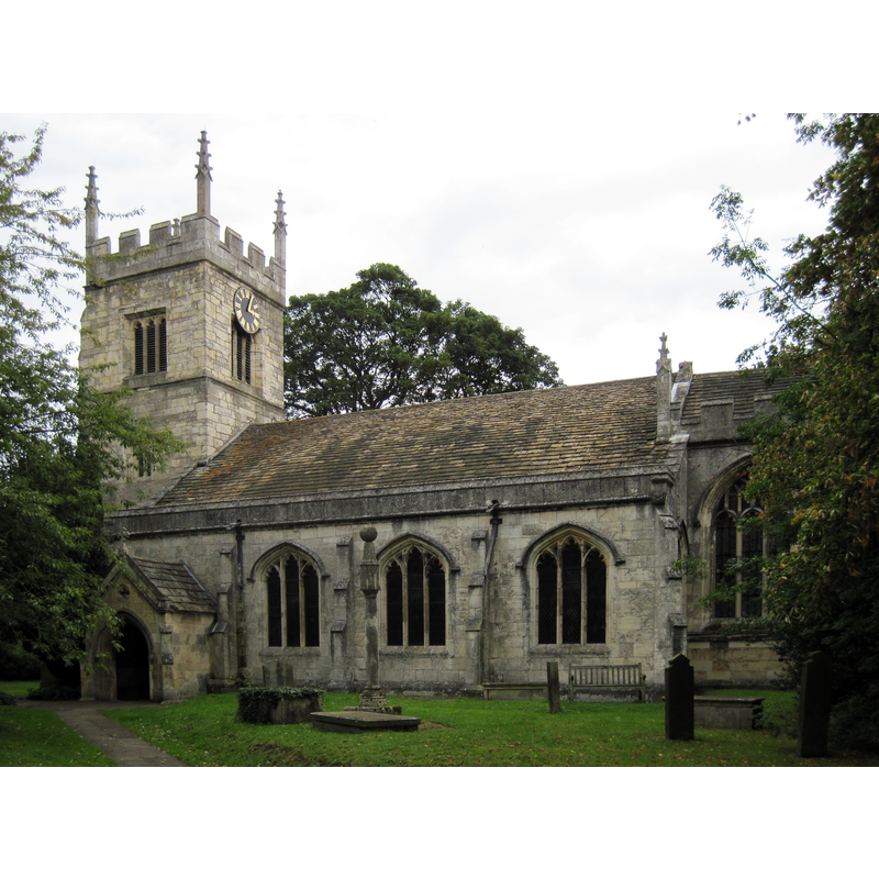
Image copyright © Martin Dawes, 2011
CC-BY-SA-2.0
Results: 4 records
view of church exterior - south view
Copyright Statement: Image copyright © Martin Dawes, 2011
Image Source: digital photograph taken 31 August 2011 by Martin Dawes [www.geograph.org.uk/photo/2629447] [accessed 11 October 2018]
Copyright Instructions: CC-BY-SA-2.0
view of church interior - nave - looking west
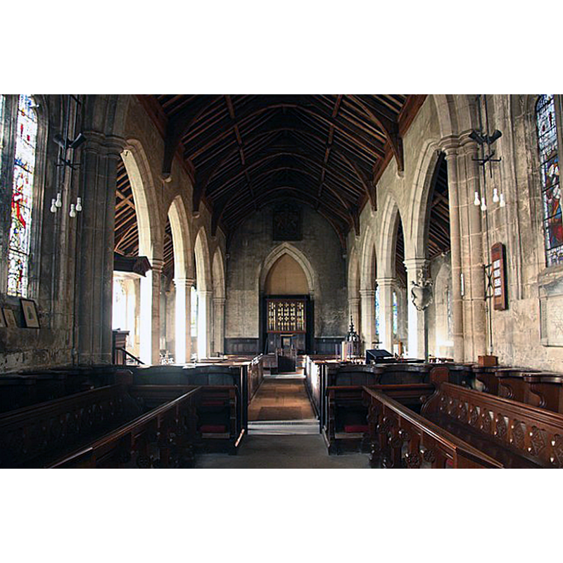
Scene Description: Source caption: "All Saints' nave. Looking west from the chancel with early Perpendicular arcades c1420".
Copyright Statement: Image copyright © Richard Croft, 2009
Image Source: digital photograph taken 4 December 2009 by Richard Croft [www.geograph.org.uk/photo/1610122] [accessed 11 October 2018]
Copyright Instructions: CC-BY-SA-2.0
view of church interior - nave - looking east
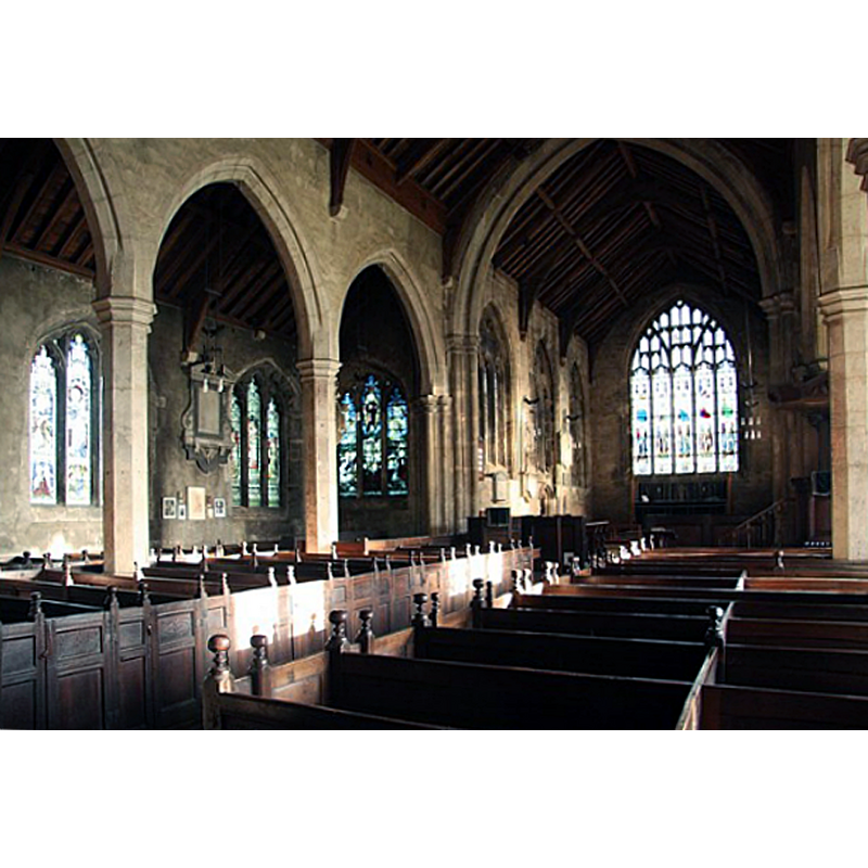
Scene Description: Source caption: "All Saints' nave. Early Perpendicular nave c1420 with Jacobean box pews".
Copyright Statement: Image copyright © Richard Croft, 2009
Image Source: digital photograph taken 4 December 2009 by Richard Croft [www.geograph.org.uk/photo/1610121] [accessed 11 October 2018]
Copyright Instructions: CC-BY-SA-2.0
view of font cover
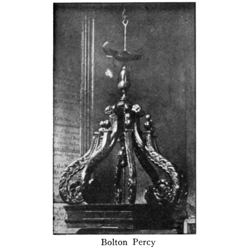
Copyright Statement: Image copyright © [in the public domain]
Image Source: digital image of an illustration in Bond (1908)
Copyright Instructions: PD
INFORMATION
Font ID: 05133BOL
Object Type: Baptismal Font1
Font Century and Period/Style: 12th century, Late Norman
Church / Chapel Name: Parish Church of All Saints
Font Location in Church: Inside the church, at the W end, N side of the nave
Church Patron Saint(s): All Saints
Church Notes: present church of 1424 built over earlier building (11thC?)
Church Address: Main St, Bolton Percy, York YO23 7AQ, UK
Site Location: North Yorkshire, Yorkshire and the Humber, England, United Kingdom
Directions to Site: Located 5-6 km ESE of Tadcaster and the A64. 15 km SW of York
Ecclesiastic Region: Diocese of York
Historical Region: Hundred of Ainsty -- formerly WRYrks
Additional Comments: present font (composite? [cf. FontNotes]) -- disappeared font? (the one from the Domesday-time church here)
Font Notes:
Click to view
There is an entry for Bolton [Percy] [variant spelling] in the Domesday survey [http://opendomesday.org/place/SE5341/bolton-percy/] [accessed 11 October 2018]; it mentions a priest and a church in it. Glynne in his 26 March 1825 visit (in Butler, 2007) notes: "The font has an elegant carved canopy." Bond (1908) provides information only on the font cover; he describes it as Jacobean, of "a common late type" which consists of "an octagonal lid moulded on the edge, which bears eight radiating trusses, rising from the angles and meeting at the head of a central baluster-shaped post, just below the finial, roughly suggesting a crown"; the part described by Bond [cf. supra] is actually the top of what is usually described as a rim-buffet font cover; it is raised on a counterweight pulley system. Noted in Morris (1932): "Old font -- perhaps Perp[endicular], with Jacobean cover. Mee (1941) notes: "12th century font with a Jacobean cover like a traceried lantern". Pevsner (1986 c1967) writes: "Font cover. Jacobean, and very handsome. Octagon with openwork tracery and scrolly top", but the Harman & Pevsner edition (2017) adds "Norman tub" to it. The RCHM (York, 1962- ) remarks on the similarity between the font cover of this font with that on the font at St. Martin's (Coney Street) in the city of York. The entry for this church in Historic England [Listing NGR: SE5317641278] reports a "Norman tub" in it. The entry for this church in the CRSBI (2018) notes "the font which may contain 12th-century material [...] Of 12thc. or early 13thc. date (Bilson 1915, 117). The bowl and pedestal taper downwards and are carved from the same block. The stem is decorated with a horizontal roll moulding while the bowl has an incised groove just above its lower edge. Near-vertical tool marks are visible. The plinth, plain, with rough diagonal tooling, is of uncertain date."
COORDINATES
UTM: 30U 618758 5969936
Latitude & Longitude (Decimal): 53.864308, -1.194049
Latitude & Longitude (DMS): 53° 51′ 51.51″ N, 1° 11′ 38.57″ W
MEDIUM AND MEASUREMENTS
Material: stone
Font Shape: octagonal, mounted
Basin Interior Shape: round
Basin Exterior Shape: octagonal
Rim Thickness: 7.5 cm [calculated]
Diameter (inside rim): 50 cm*
Diameter (includes rim): 65 cm*
Basin Total Height: 36.5 cm*
Height of Base: 39 cm*
Font Height (less Plinth): 75.5 cm [calculated]
Notes on Measurements: * CRSBI (2018)
LID INFORMATION
Date: 17th - 18th century?
Material: wood, oak
Apparatus: yes, coutherweight pulley system
Notes: rim-buffet type [cf. FontNotes]
REFERENCES
- Bond, Francis, Fonts and Font Covers, London: Waterstone, 1985 c1908, p. 289, 291 and ill. [of the cover only] on p. 312
- Glynne, Stephen Richard, The Yorkshire notes of Sir Stephen Glynne (1825-1874), Woodbridge: The Boydell Press; Yorkshire Archaeological Society, 2007, p. 106
- Great Britain. Royal Commission on Historical Monuments (England), An Inventory of the Historical Monuments in the city of York, London: H.M. Stationary Office, 1962-, vol. 3: lii
- Harman, Ruth, Yorkshire West Riding: Sheffield and the South, New Haven; London: Yale University Press, 2017, p. 134
- Mee, Arthur, The King's England, Yorkshire, West Riding, London: Hodder & Stoughton, 1941, p. 70
- Morris, Joseph Ernest, The West Riding of Yorkshire, London: Methuen & Co., 1932, p. 117
- Pevsner, Nikolaus, Yorkshire: the West Riding, Harmondsworth: Penguin Books, 1986 c1967, p. 116
- Pevsner, Nikolaus, Yorkshire: the West Riding, Harmondsworth: Penguin Books, 1986 c1967, p. 44