Sompting / Suntinge / Sultinges
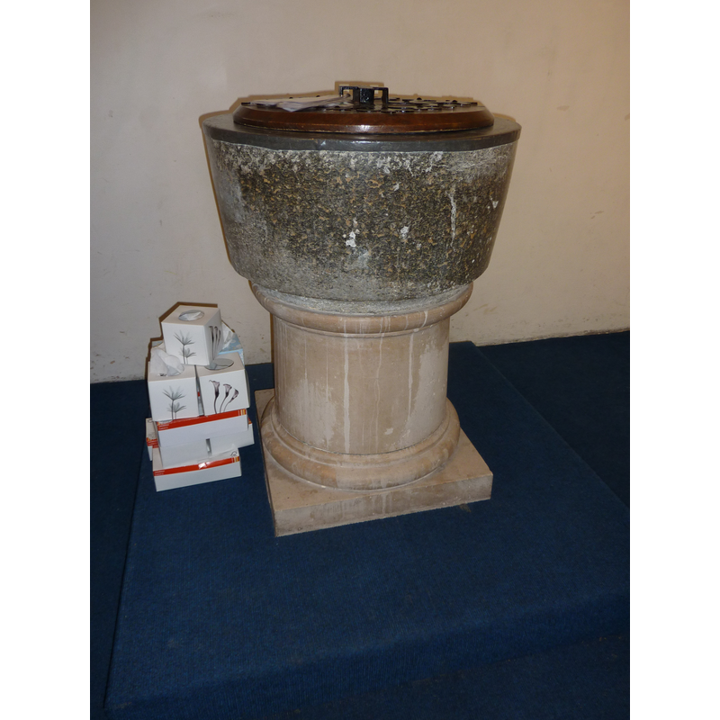
Image copyright © Janice Tostevin, 2010
Standing permission
Results: 9 records
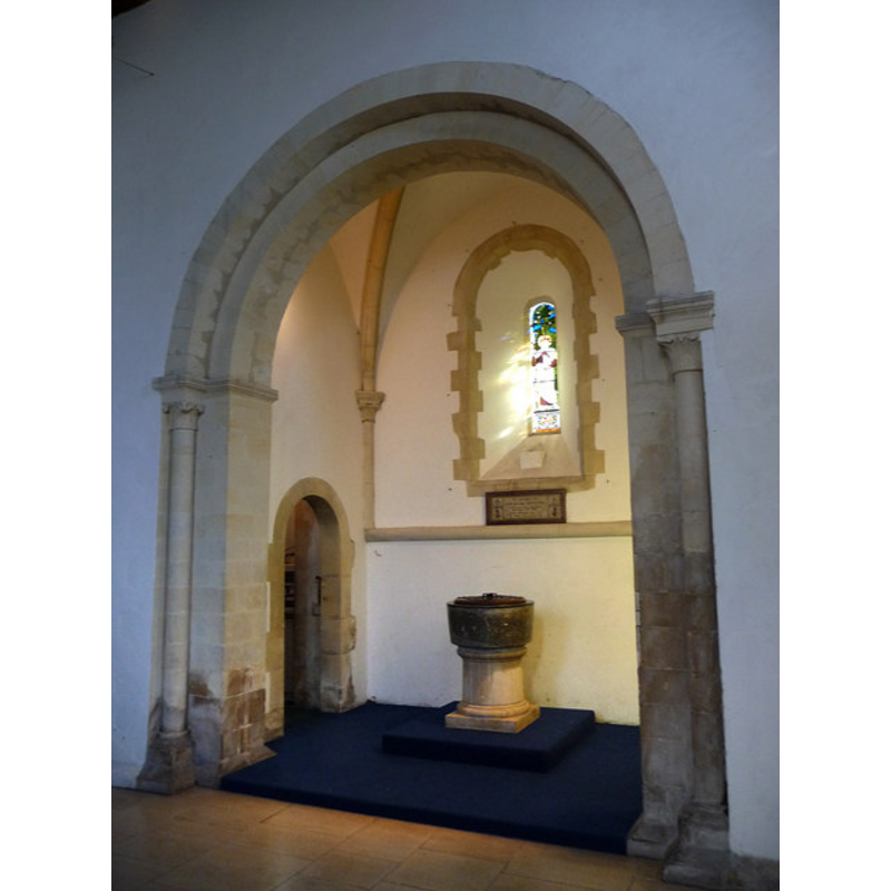
view of font and cover
Scene Description: the stem, the lower base and the cover are modern; so is the new 'lead' lining
Copyright Statement: Image copyright © Janice Tostevin, 2010
Image Source: digital photograph taken 6 March 2010 by Janice Tostevin for BSI
Copyright Instructions: Standing permission
view of font
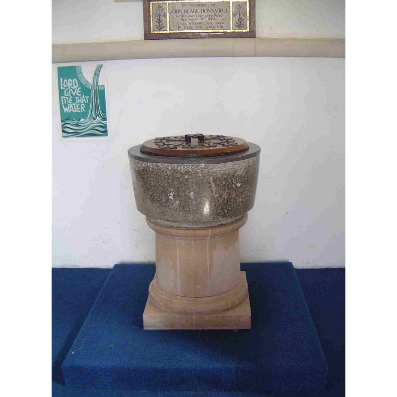
Copyright Statement: Image copyright © Paul Zwierzanski, 2002
Image Source: Paul Zwierzanski, of www.yeoldesussexpages.co.uk
Copyright Instructions: Image and permision received (e-mail Nov. 4, 2003)
view of basin
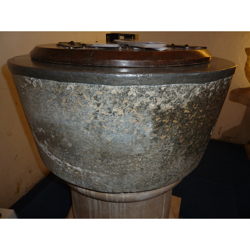
Copyright Statement: Image copyright © Janice Tostevin, 2010
Image Source: digital photograph taken 6 March 2010 by Janice Tostevin for BSI
Copyright Instructions: Standing permission
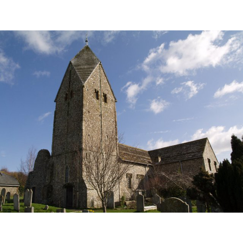
view of church exterior - west view
Copyright Statement: Image copyright © Kinnerton, 2010
Image Source: digital photograph taken 10 October 2010 by Kinnerton [http://en.wikipedia.org/wiki/File:Sompting_Church_ext_from_west.JPG] [accessed 12 October 2012]
Copyright Instructions: CC-BY-SA-3.0
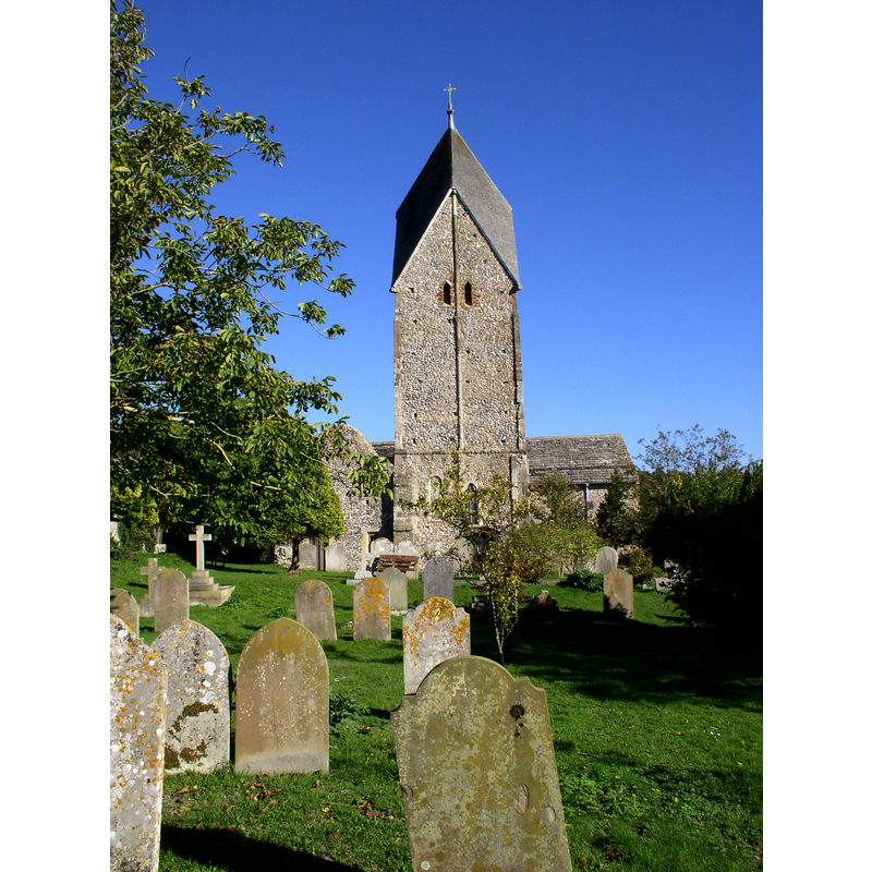
view of church exterior - southwest view
Copyright Statement: Image copyright © Tristan Forward, 2007
Image Source: digital photograph taken October 2007 by Tristan Forward [www.geograph.org.uk/photo/1597554] [accessed 12 October 2012]
Copyright Instructions: CC-BY-SA-3.0
view of church exterior - east view
![EXT SE digital photograph taken 6 March 2009 by Chris Gunns [www.geograph.org.uk/photo/1194036] [accessed 12 October 2012]
EXT SW digital photograph taken October 2007 by Tristan Forward [www.geograph.org.uk/photo/1597554] [accessed 12 October 2012
EXT TOWER digital photograph taken 10 October 2010 by Kinnerton [http://en.wikipedia.org/wiki/File:Sompting_Church_ext_from_west.JPG] [accessed 12 October 2012] CCL
INT wFontinaisle digital photograph taken 6 March 2009 by Chris Gunns [www.geograph.org.uk/photo/1193922] [accessed 12 October 2012]
FONT IN CONTEXT digital photograph taken 6 March 2009 by Chris Gunns [www.geograph.org.uk/photo/1194003] [accessed 12 October 2012]
STOUP? NEXT LECTERN digital photograph taken 12 March 2011 by Basher Eyre [www.geograph.org.uk/photo/2347919] [accessed 12 October 2012]](/static-50478a99ec6f36a15d6234548c59f63da52304e5/compressed/1130428071_compressed.png)
Scene Description: EXT SE digital photograph taken 6 March 2009 by Chris Gunns [www.geograph.org.uk/photo/1194036] [accessed 12 October 2012]
EXT SW digital photograph taken October 2007 by Tristan Forward [www.geograph.org.uk/photo/1597554] [accessed 12 October 2012
EXT TOWER digital photograph taken 10 October 2010 by Kinnerton [http://en.wikipedia.org/wiki/File:Sompting_Church_ext_from_west.JPG] [accessed 12 October 2012] CCL
INT wFontinaisle digital photograph taken 6 March 2009 by Chris Gunns [www.geograph.org.uk/photo/1193922] [accessed 12 October 2012]
FONT IN CONTEXT digital photograph taken 6 March 2009 by Chris Gunns [www.geograph.org.uk/photo/1194003] [accessed 12 October 2012]
STOUP? NEXT LECTERN digital photograph taken 12 March 2011 by Basher Eyre [www.geograph.org.uk/photo/2347919] [accessed 12 October 2012]
Copyright Statement: Image copyright © Chris Gunns, 2009
Image Source: digital photograph taken 6 March 2009 by Chris Gunns [www.geograph.org.uk/photo/1194036] [accessed 12 October 2012]
Copyright Instructions: CC-BY-SA-3.0
view of font in context
Scene Description: in the baptistery, north transept
Copyright Statement: Image copyright © Chris Gunns, 2009
Image Source: digital photograph taken 6 March 2009 by Chris Gunns [www.geograph.org.uk/photo/1194003] [accessed 12 October 2012]
Copyright Instructions: CC-BY-SA-3.0
view of church interior - nave - looking east
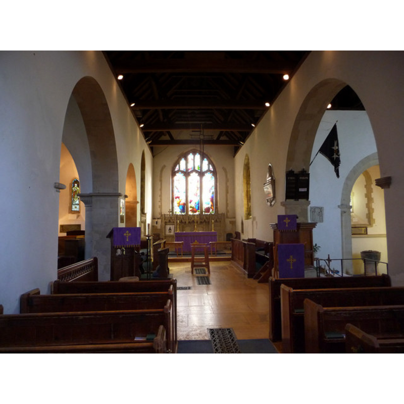
Scene Description: the font visible in the south transept
Copyright Statement: Image copyright © Chris Gunns, 2009
Image Source: digital photograph taken 6 March 2009 by Chris Gunns [www.geograph.org.uk/photo/1193922] [accessed 12 October 2012]
Copyright Instructions: CC-BY-SA-3.0
view of stoup
![is it a stoup, or a mini font? [cf. FontNotes]](/static-50478a99ec6f36a15d6234548c59f63da52304e5/compressed/1130428076_compressed.png)
Scene Description: is it a stoup, or a mini font? [cf. FontNotes]
Copyright Statement: Image copyright © Basher Eyre, 2011
Image Source: digital photograph taken 12 March 2011 by Basher Eyre [www.geograph.org.uk/photo/2347919] [accessed 12 October 2012]
Copyright Instructions: CC-BY-SA-3.0
INFORMATION
Font ID: 04770SOM
Object Type: Baptismal Font1
Font Century and Period/Style: 12th - 13th century [re-tooled?] [basin only], Medieval [composite]
Church / Chapel Name: Parish Church of St. Mary the Blessed Virgin
Font Location in Church: In a barrel-vaulted recess or chapel on the east side -- the chapel in the S transept is used as baptistery [cf. FontNotes for the origin of this chapel]
Church Patron Saint(s): St. Mary the Virgin
Church Notes: Probably built in the mid-10th century; appears on the Domesday Book of 1086; granted to Knights Templar in the 12th century. Famous for the four-sided gabled spire of its tower ["Rhenish helm" type] -- "The church of ST. MARY, so called in 1442" [cf. VCH entry in FontNotes]
Church Address: Church Lane, Sompting, West Sussex, BN15 OAZ
Site Location: West Sussex, South East, England, United Kingdom
Directions to Site: Sompting is now a suburb of Worthing, 3 km NE of the town centre
Ecclesiastic Region: Diocese of Chichester
Historical Region: Hundred of Brightford -- Rape of Bramber -- Sussex
Additional Comments: [Tim Clarke gave his permission to use his image but the quality of the web image was not good enough for reproduction here -- Later requested Paul Zwierzanski, of www.yeoldesussexpages.co.uk, for his permission - granted e-mail Dec. 10, 2002]
Font Notes:
Click to view
Drawing of a font in the Harvey Pridham Drawings of English Fonts (MS 56). [Folder Number, Item Description]. University of Colorado at Boulder Libraries. Special Collections Dept., done by Harvey Pridham in December 1888 accompanied by the following description: "All circular, of black marble, "freshed up." Circular bowl inside, zinc lining turned over 3/4 inch down face, sides within raked. The same as without, 10 inches deep, 3 1/2 margin: Modern flat cover. Position, in chantry on the East side of South Transept. See a separate sketch thereof." Listed in Cox & Harvey (1907) as a baptismal font of the Norman period. Harrison (1920), who does not mention the font in it, writes of this church: "The tower is the only example in England of a Saxon tower with four-sided gabled spire, resembling those of the Rhenish Provinces — Coblentz, Andernach, and the Apostles' Church at Cologne. The cap is "Helm" form." Described in Hutton (1957) as a Saxon or early Norman font, without further detail. The Victoria County History (Sussex, vol. 6, pt. 1, 1980) notes: "Architectural evidence shows that there was a church at Sompting in the early 11th century, and one was recorded there in 1086. [...] The nave and chancel were rebuilt after the church was acquired by the Templars in 1154 [...] The plain, circular, 12th-century font stands in the south transept." Described in Whiteman (1994): "To the south they [the Knights Templar, who were given the church in the 12th century] built a transeptal chapel for their own use; this now forms the church entrance and baptistery, the latter containing a circular Norman font of Sussex marble." Described and illustrated in the Parish web site [www.bn15.co.uk/stmary.html] [accessed 12 November 2002]: "marble Norman font, although on a modern pillar"; it is a plain almost cylindrical basin, slightly narrower at the bottom; the broad columnar pedestal and the square plinth are modern, as is the flat wooden cover.
Credit and Acknowledgements: We are grateful to Peter Deventon for his help in documenting this font; to Paul Zwierzanski, of www.yeoldesussexpages.co.uk, and Janice Tostevin, for their photographs of this font
COORDINATES
UTM: 30U 686473 5635224
Latitude & Longitude (Decimal): 50.838638, -0.351527
Latitude & Longitude (DMS): 50° 50′ 19.1″ N, 0° 21′ 5.5″ W
MEDIUM AND MEASUREMENTS
Material: stone, marble
Number of Pieces: only the basin is original
Font Shape: bucket-shaped, mounted
Basin Interior Shape: round
Basin Exterior Shape: round
Drainage System: centre hole in basin
Drainage Notes: lead-lined [or is it zinc?]
Basin Depth: 25 cm*
Notes on Measurements: * [in inches in Harvey Pridham [cf. FontNotes]]
LID INFORMATION
Date: modern
Material: wood
Apparatus: no
Notes: flat wooden lid with metal reinforcements
REFERENCES
- Victoria County History [online], University of London, 1993-. URL: https://www.british-history.ac.uk.
- Cox, John Charles, English Church Furniture, New York: E.P. Dutton & Co., 1907, p. 223
- Harrison, Frederick, Notes on Sussex churches, Hove: Combridges, 1920, p. 188-190
- Hutton, Graham, English Parish Churches, London: Thames & Hudson, 1976, p. 34
- Whiteman, Ken, Ancient Churches of Suffolk, Seaford, East Sussex: S.B. Publications, 1998, p. 143