Bourg-Dun No. 2 / Burgo Duni / Dunus / Flainville / Le Bourg-Dun
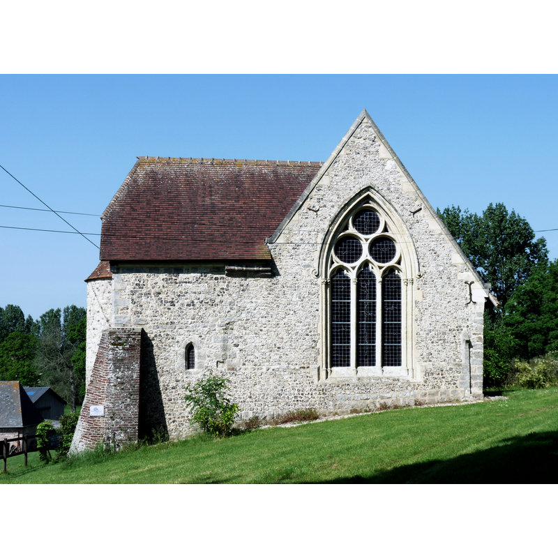
Image copyright © Paubry, 2012
CC-BY-SA-3.0
Results: 1 records
view of church exterior - north view
Copyright Statement: Image copyright © Paubry, 2012
Image Source: digital photograph taken 28 May 2012 by Paubry [https://commons.wikimedia.org/wiki/File:Flainville.JPG] [accessed 13 June 2017]
Copyright Instructions: CC-BY-SA-3.0
INFORMATION
Font ID: 04278BOU
Object Type: Baptismal Font1
Font Century and Period/Style: 17th century
Church / Chapel Name: Chapelle Saint-Julien de Flainville [now a private property]
Font Location in Church: Inside the chapel
Church Patron Saint(s): St. Julian
Church Notes: The Dictionnaire des églises... (1966- ) gives the date of this chapel as 1324 and informs that it was built by Estout de Grouchet in honour of St. Julian; the ceiling hes paintings of musical angels and there also frescoes on the walls, one depicting the Adoration of the Magi -- listed in Mérimée [ref.: PA00100579]: "Chapelle Saint-Julien sise au hameau de Flainville [...] A l'origine, existait sans doute une maison-forte du 13e siècle, sur plan massé, en maçonnerie de silex et grès. Ce manoir fortifié devient chapelle par agrandissement et construction, au nord, d'un vaisseau, la partie ancienne (avec tourelle d'angle) devenant la chapelle seigneuriale. L'ensemble reçoit, fin 14e ou début 15e siècle, un décor peint. La chapelle fait partie d'un ensemble manorial de plan carré, comprenant plusieurs bâtiments d'habitation contigus construits aux 18e et 19e siècles."
Church Address: 13 route de la Chapelle Saint-Julien, route de Flainville, 76740 Le Bourg-Dun, France -- Tel.: 02 35 84 19 55
Site Location: Seine-Maritime, Haute-Normandie, France, Europe
Directions to Site: In the hamlet of Flainville, off the D237, near Le Bourg-Dun, itself located 19 km SSW of Dieppe, in the canton d'Offranville
Ecclesiastic Region: Diocèse de Rouen
Historical Region: Caux Maritime, Pays de Caux
Font Notes:
Click to view
Described in the Dictionnaire des églises... (1966- ) simply as a sandstone baptismal font with a wooden cover, both of the 17th century. The web site of Pays Plateau de Caux Maritime notes that this chapel served as parish church in the 17th century: "Cette chapelle servit d’église paroissiale au XVIIème siècle, et abrite une petite chapelle seigneuriale. La voûte de cette chapelle possède une fresque représentant huit anges musiciens avec leurs instruments de musique."
COORDINATES
UTM: 31U 348847 5527735
Latitude & Longitude (Decimal): 49.882911, 0.895933
Latitude & Longitude (DMS): 49° 52′ 58.48″ N, 0° 53′ 45.36″ E
MEDIUM AND MEASUREMENTS
Material: stone, sandstone
LID INFORMATION
Date: 17th century?
Material: wood
REFERENCES
- Dictionnaire des églises de France, Belgique, Luxembourg, Suisse, Paris: R. Laffont, 1966-, IV B 23