Uzerche No. 2 / Usercha
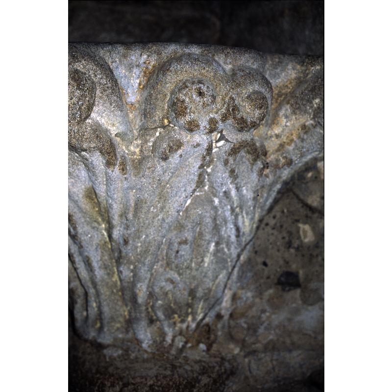
Image copyright © Baptisteria Sacra Index, 2023
CC-BY-NC-ND-4.0
Results: 4 records
design element - motifs - foliage
Scene Description: ending up in large scrolls
Copyright Statement: Image copyright © Baptisteria Sacra Index, 2023
Image Source: digital image of a photograph taken 28 June 2001 by BSI
Copyright Instructions: CC-BY-NC-ND-4.0
view of basin - upper view
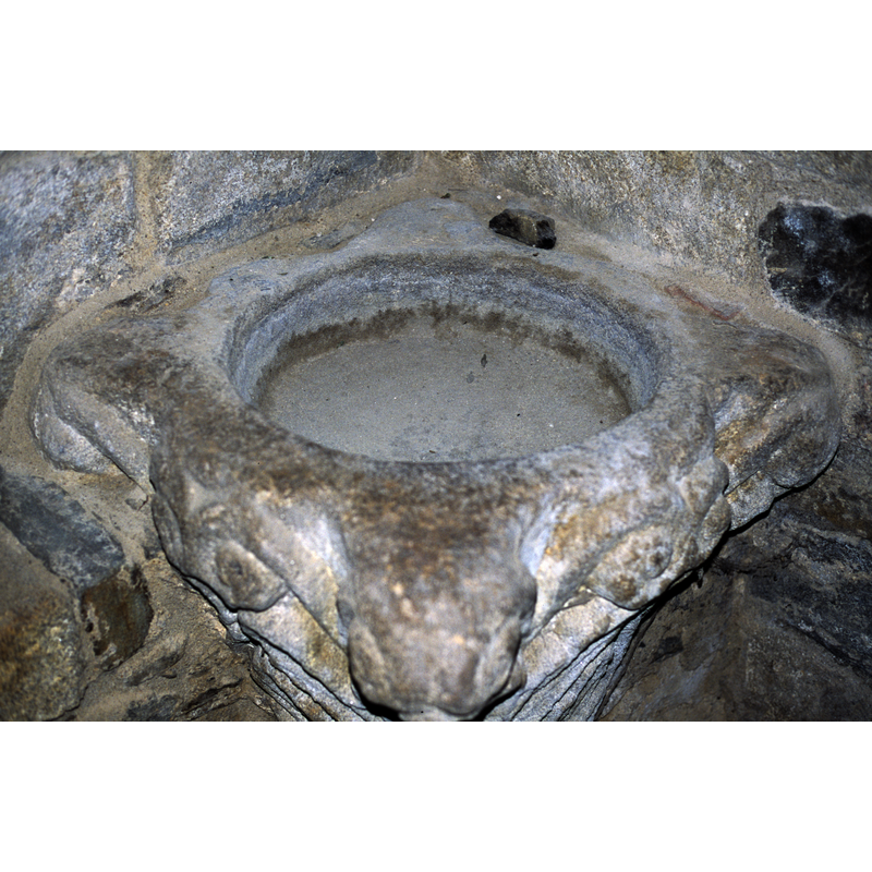
Scene Description: partially cemented to the southeast corner
Copyright Statement: Image copyright © Baptisteria Sacra Index, 2023
Image Source: digital image of a photograph taken 28 June 2001 by BSI
Copyright Instructions: CC-BY-NC-ND-4.0
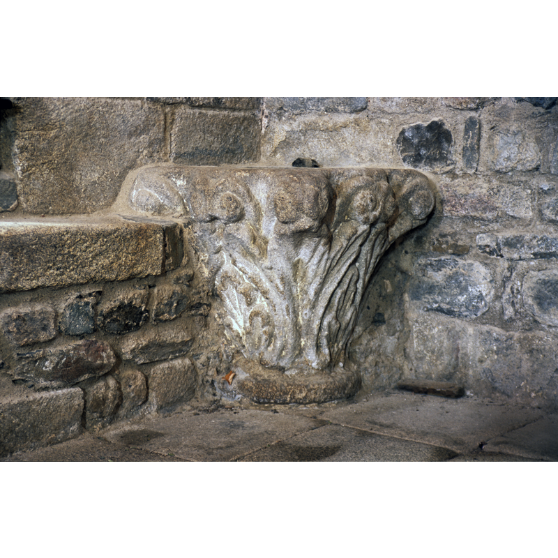
view of stoup
Copyright Statement: Image copyright © Baptisteria Sacra Index, 2023
Image Source: digital image of a photograph taken 28 June 2001 by BSI
Copyright Instructions: CC-BY-NC-ND-4.0
information

Copyright Statement: Image copyright © Baptisteria Sacra Index, 2023
Image Source: digital image of field notes taken 28 June 2017 by BSI
Copyright Instructions: CC-BY-NC-ND-4.0
INFORMATION
Font ID: 03738UZE
Object Type: Stoup
Date Visited: 2001-06-28
Font Century and Period/Style: 11th - 12th century, Romanesque
Church / Chapel Name: Église parossiale Saint-Pierre
Font Location in Church: Inside the church, on the E side of the S doorway into the crossing
Church Patron Saint(s): St. Peter
Church Notes: church here by the 6thC; destroyed by Vikings 860; present church 12thC; re-built early 14thC -- listed in Mérimée [ref.: PA00099947]: "Une église est mentionnée dans la commune dès le 6e siècle. Vers l'an 760, Pépin le Bref fait réparer l'église, élever une forteresse et fonder un monastère. En 860, l'ensemble est détruit par les Normands. L'église et le monastère sont rétablis vers 980. En 1028, le monastère et l'église sont ravagés par un incendie et restaurés peu après par les religieux. Vers 1312, l'église prend son aspect actuel, en conservant quelques éléments anciens. Le monastère est détruit au 15e siècle et l'église ravagée. En 1747, l'ancien monastère est remplacé par une collégiale. L'église est affectée au chapitre à cette époque, puis à la paroisse en 1801."
Church Address: 19140 Uzerche, France
Site Location: Corrèze, Nouvelle-Aquitaine, France, Europe
Directions to Site: Located off the D3-D920 crossroads, NW of Tulle, about 50 kms SE of Limoges down the A20/E09
Ecclesiastic Region: Diocèse de Tulle [ancien diocèse de Limoges]
Historical Region: Limousin
Additional Comments: recycled stoup: one of three in the same church, St-Pierre, Uzerche, formerly Romanesque capitals
Font Notes:
Click to view
Listed in the Phaidon guide (France, 1985, p. 745) as one of three capitals "converted into holy-water stoups". [cf. Index entries for Uzerche Nos. 1 & 3]. Enlart (1902, p. 784 footnote 3) lists recycled "Chapiteaux romans" but does not specify how many or details of ornamentation. On-site notes: this capital, similar to the one opposite, on the west side, is however ornamented with foliage motifs and scrolls, and has now been partially built into the wall at the east corner. The church was being heavily restored at the time of our visit [June 2001]
COORDINATES
Latitude & Longitude (Decimal): 45.4247, 1.56377
Latitude & Longitude (DMS): 45° 25′ 28.92″ N, 1° 33′ 49.57″ E
MEDIUM AND MEASUREMENTS
Material: stone, granite?
Number of Pieces: one
Font Shape: square (unmounted)
Basin Interior Shape: round
Basin Exterior Shape: square
Drainage System: no drainage system
Rim Thickness: 8-23 cm
Diameter (inside rim): 46-48 cm
Basin Depth: 12 cm
Basin Total Height: 68 cm
Font Height (less Plinth): 68 cm
Trapezoidal Basin: 65 x 67 cm
Notes on Measurements: BSI on-site
REFERENCES
- Enlart, Camille, Manuel d'archéologie française depuis les temps mérovingiens jusqu'à la Renaissance, Paris: Alphonse Picard & fils, 1902, p. 784 footnote 3
- Phaidon, France: a Phaidon cultural guide, Englewood Cliffs NJ: Prentice-Hall, 1985, p. 745