Bohain-en-Vermandois
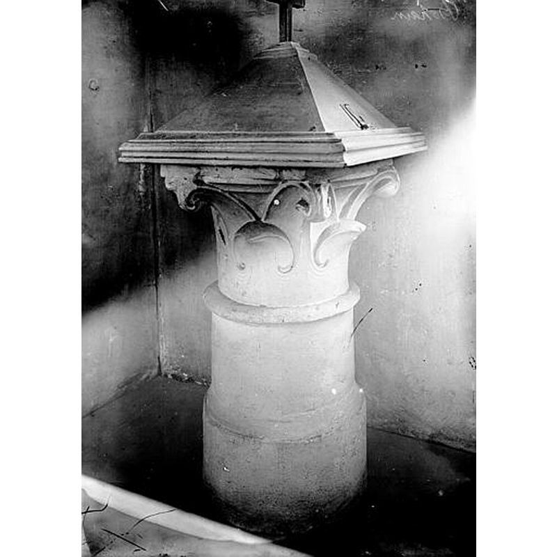
Image copyright © Ministère de la Culture (France), Médiathèque de l'architecture et du patrimoine, diffusion RMN-GP, 2025
CC-BY-SA-NC-ND 4.0 = Licence Ouverte / CC-BY-SA-4.0
Results: 2 records
view of font and cover
Scene Description: Source caption: "Fonts baptismaux"
Copyright Statement: Image copyright © Ministère de la Culture (France), Médiathèque de l'architecture et du patrimoine, diffusion RMN-GP, 2025
Image Source: digital image of an undated [pre-1928] B&W photograph by Camille Enlart [https://pop.culture.gouv.fr/notice/memoire/APMH00028017] [accessed 19 March 2025]
Copyright Instructions: CC-BY-SA-NC-ND 4.0 = Licence Ouverte / CC-BY-SA-4.0
design element - motifs - foliage
Copyright Statement: Image copyright © Ministère de la Culture (France), Médiathèque de l'architecture et du patrimoine, diffusion RMN-GP, 2025
Image Source: digital image of an undated [pre-1928] B&W photograph by Camille Enlart [https://pop.culture.gouv.fr/notice/memoire/APMH00028017] [accessed 19 March 2025]
Copyright Instructions: CC-BY-SA-NC-ND 4.0 = Licence Ouverte / CC-BY-SA-4.0
INFORMATION
Font ID: 03114BOH
Object Type: Baptismal Font1
Object Details: capital
Font Century and Period/Style: 12th century (?) / 15th century (?), [altered]
Church / Chapel Name: Église Notre-Dame-de-Lourdes de Bohain-en-Vermandois
Font Location in Church: Inside the church
Church Patron Saint(s): St. Mary the Virgin
Church Notes: original church 1251; replaced by a new church in 1674; present church of 1910 is he third on the site
Church Address: 31 Rue Jean Jaurès, 02110 Bohain-en-Vermandois, France -- Tel.: +33 3 23 07 13 10
Site Location: Aisne, Hauts-de-France, France, Europe
Directions to Site: Bohain-en-Vermandois is located off the D8-D960 crossroads, 20 km NE of Saint-Quentin.
Additional Comments: altered font (re-purposed capital) -- disappeared font? (the one from the 12thC church here)
Font Notes:
Click to view
Listed by Enlart (1902) in a group of pedestal fonts and dated to the 12th century. The entry for this church in Généalogie Aisne [https://www.genealogie-aisne.com/articles/bohain-lhistoire-des-eglises/] [accessed 19 March 2025] informs that the baptismal font in the of the 1674 re-building was 12th-century, the date of the portal ["Les fonds [sic] baptismaux et le portail était du XIIème siècle"]; it further mentions a former 15th-century capital that was re-purposed as holy-water stoup ["Quant aux anciens fonts baptismaux qui semblent être un chapiteau du XVème siècle, furent creusé pour en faire un bénitier."] This latter object is probably the one listed in Mémoire [ref.: APMH00028017] with a photograph by Enlart [cf. ImagesArea]
COORDINATES
UTM: 31U 532429 5537254
Latitude & Longitude (Decimal): 49.986734, 3.452365
Latitude & Longitude (DMS): 49° 59′ 12.24″ N, 3° 27′ 8.51″ E
MEDIUM AND MEASUREMENTS
Material: stone, type unknown
Font Shape: round, mounted
Basin Interior Shape: round
Basin Exterior Shape: round
LID INFORMATION
Date: modern?
Material: wood
Apparatus: no
Notes: square pyramid with cross finial; modern
REFERENCES
- Enlart, Camille, Manuel d'archéologie française depuis les temps mérovingiens jusqu'à la Renaissance, Paris: Alphonse Picard & fils, 1902, p. 776 footnote 5
- France, Ministère de la culture, Inventaire Général, Mémoire / POP : la plateforme ouverte du patrimoine (Ministère de la culture, Inventaire Général), 2024. URL: https://www.pop.culture.gouv.fr/search/mosaic?base=%5B%22Photographies%20%28M%C3%A9moire%29%22%5D.