Fontaine-sur-Somme / Fontaines-sur-Somme
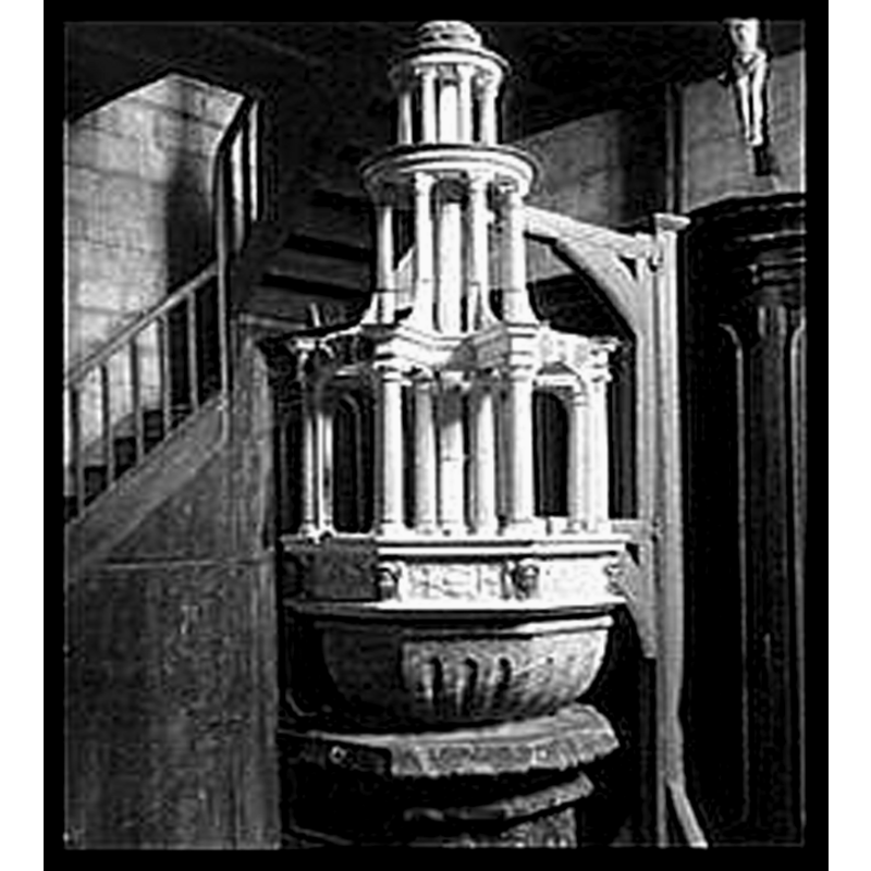
Image copyright © Ministère de la Culture (France) - Médiathèque de l'architecture et du patrimoine, 2016
CC-BY-SA-NC-ND 4.0 = Licence Ouverte / CC-BY-SA-4.0
Results: 4 records
view of font and cover
Copyright Statement: Image copyright © Ministère de la Culture (France) - Médiathèque de l'architecture et du patrimoine, 2016
Image Source: digital image of a B&W photograph taken by Philippe Des Forts, in Mémoire [www.culture.gouv.fr/Wave/image/memoire/0002/sap01_dsf3246p_t.jpg] [accessed 30 April 2016]
Copyright Instructions: CC-BY-SA-NC-ND 4.0 = Licence Ouverte / CC-BY-SA-4.0
view of church exterior - north portal - detail
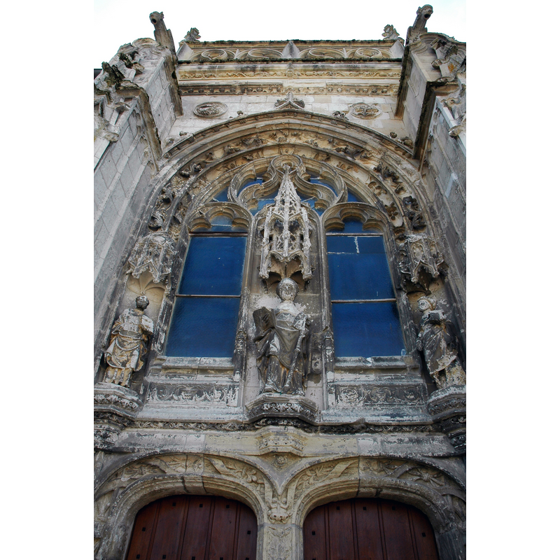
Copyright Statement: Image copyright © isamiga76, 2011
Image Source: digital photograph taken 10 August 2011 by isamiga76 [https://commons.wikimedia.org/wiki/File:Fontaine_-sur-Somme,Somme,France_(6032441796).jpg] [accessed 30 April 2016]
Copyright Instructions: CC-BY-2.0
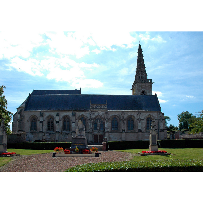
view of church exterior - southwest end

Copyright Statement: Image copyright © isamiga76, 2011
Image Source: digital photograph taken 10 August 2011 by isamiga76 [https://commons.wikimedia.org/wiki/File:Fontaine_-sur-Somme,Somme,France_(6032443314).jpg] [accessed 30 April 2016]
Copyright Instructions: CC-BY-2.0
view of church exterior - north view
Copyright Statement: Image copyright © isamiga76, 2011
Image Source: digital photograph taken 10 August 2011 by isamiga76 [https://commons.wikimedia.org/wiki/File:Fontaine_-sur-Somme,Somme,France_(6031890319).jpg] [accessed 30 April 2016]
Copyright Instructions: CC-BY-2.0
INFORMATION
Font ID: 02833FON
Object Type: Baptismal Font1
Font Date: 1590?
Font Century and Period/Style: 16th century(late?) [composite font?], Renaissance [composite]
Church / Chapel Name: Église paroissiale Saint-Riquier de Fontaine-sur-Somme
Font Location in Church: Inside the church
Church Patron Saint(s): St. Riquier
Church Notes: 15th-16thC church; modified 17thC -- listed in Mérimée [ref.: PA00116157]
Church Address: 7 rue de Haut, 80510 Fontaine-sur-Somme, France
Site Location: Somme, Hauts-de-France, France, Europe
Directions to Site: Located off (S) the D3 [aka rue de Haut], 16 km SE of Abbeville, itself about 33 kms NW of Amiens.
Ecclesiastic Region: Diocèse d'Amiens
Historical Region: Picardie
Additional Comments: composite font?
Font Notes:
Click to view
Enlart (1902) reports a wooden Renaissance cover on this font. The font and cover are listed and illustrated in Mémoire [ref.: DSF 3246 P] and described as being of stone, dated 1590, and furnished with a wooden cover [NB: not clear from this source whether the font, the cover or both are dated 1590]. The font consists of an octagonal basin with a rounded gadrooned underbowl, raised on a moulded octagonal pedestal base; they do not seem to belong together. Ornate wooden cover of openwork attached to a side crane.
COORDINATES
UTM: 31U 423950 5542395
Latitude & Longitude (Decimal): 50.028958, 1.93819
Latitude & Longitude (DMS): 50° 1′ 44.25″ N, 1° 56′ 17.48″ E
MEDIUM AND MEASUREMENTS
Material: stone, type unknown
Font Shape: octagonal, mounted
Basin Interior Shape: round
Basin Exterior Shape: octagonal
INSCRIPTION
Inscription Language: numbers
Inscription Location: [cf. FontNotes]
Inscription Text: "1590"
Inscription Notes: [cf. FontNotes]
Inscription Source: [cf. FontNotes]
LID INFORMATION
Date: 1590?
Material: wood
Apparatus: yes; side crane
Notes: [cf. FontNotes]
REFERENCES
- Enlart, Camille, Manuel d'archéologie française depuis les temps mérovingiens jusqu'à la Renaissance, Paris: Alphonse Picard & fils, 1902, p. 765, foot-note 2