Wroxham / Urochham / Urochesham / Urocsham
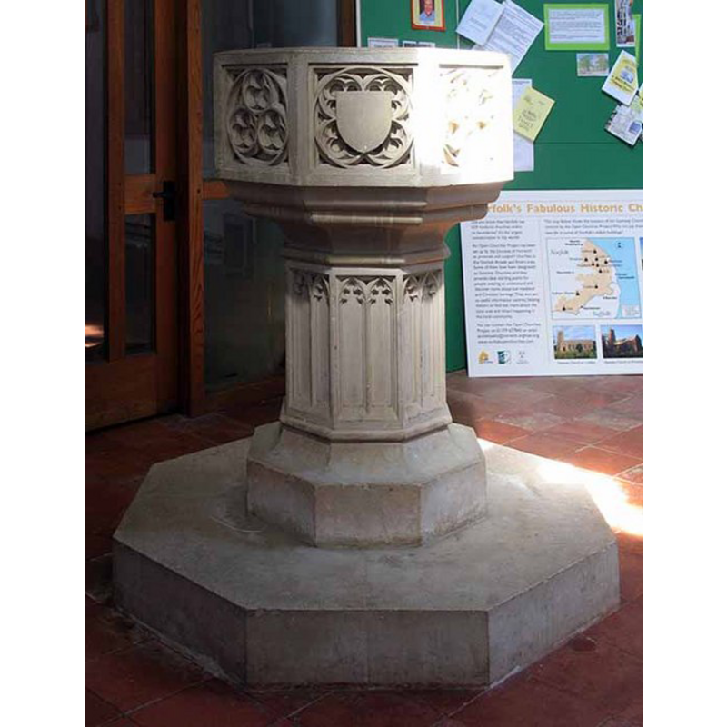
Image copyright © John Salmon, 2008
CC-BY-SA-3.0
Results: 11 records
view of font
Scene Description: [cf. FontNotes]
Copyright Statement: Image copyright © John Salmon, 2008
Image Source: digital photograph taken 7 May 2008 by John Salmon [www.geograph.org.uk/photo/804989] [accessed 22 August 2013]
Copyright Instructions: CC-BY-SA-3.0
view of font and cover
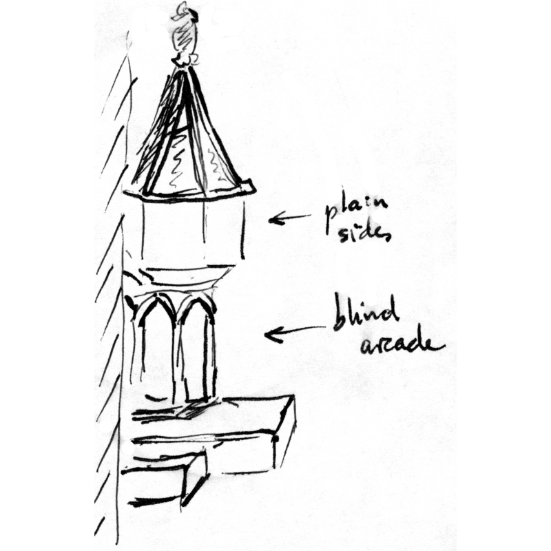
Copyright Statement: Image copyright © Baptisteria Sacra Index, 2023
Image Source: sketch by M. Torrens based on bibliographic sources [cf. FontNotes]
Copyright Instructions: CC-BY-NC-ND-4.0
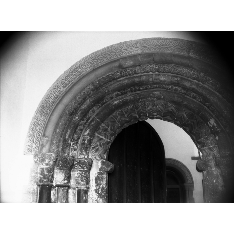
view of church exterior - south portal
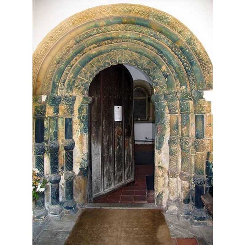
Copyright Statement: Image copyright © John Salmon, 2008
Image Source: digital photograph taken 7 May 2008 by John Salmon [www.geograph.org.uk/photo/804981] [accessed 22 August 2013]
Copyright Instructions: CC-BY-SA-3.0
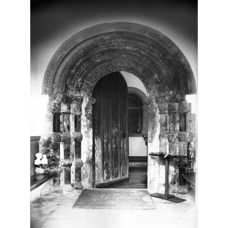
view of church exterior - south porch
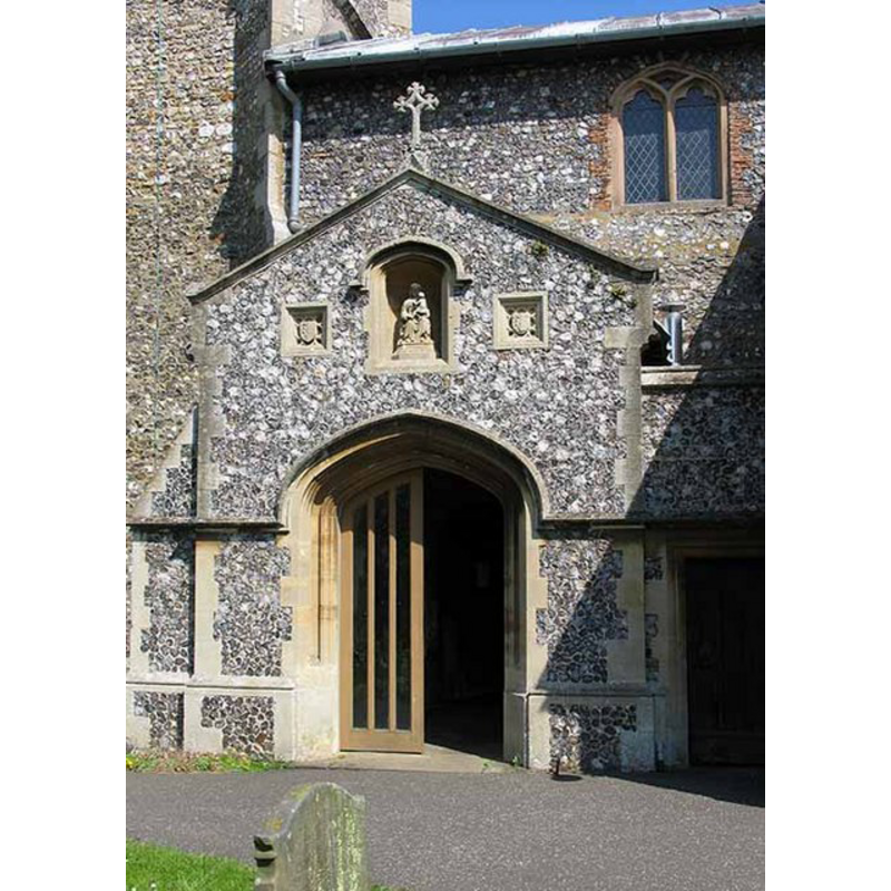
Copyright Statement: Image copyright © John Salmon, 2008
Image Source: digital photograph taken 7 May 2008 by John Salmon [www.geograph.org.uk/photo/804979] [accessed 22 August 2013]
Copyright Instructions: CC-BY-SA-3.0
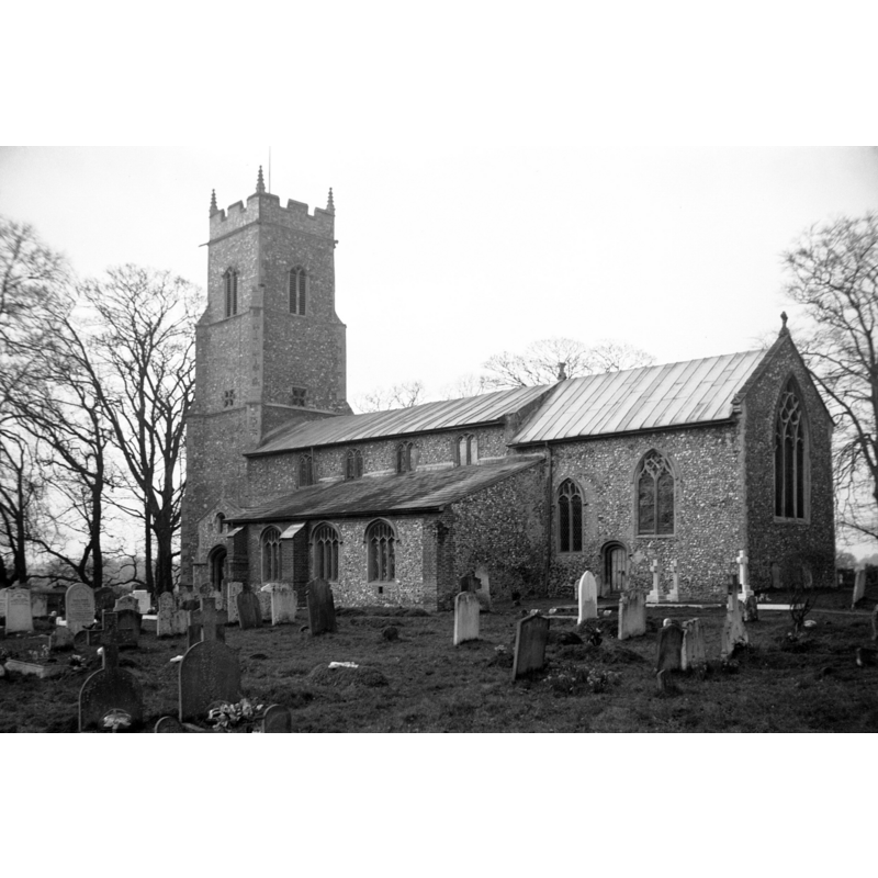
view of church exterior - southeast view
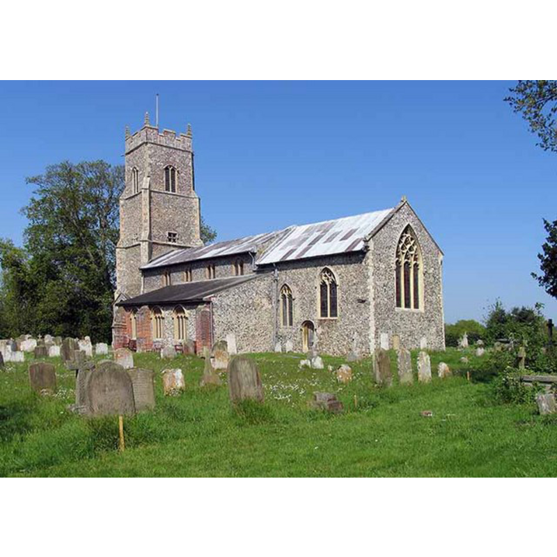
Copyright Statement: Image copyright © John Salmon, 2008
Image Source: digital photograph taken 7 May 2008 by John Salmon [www.geograph.org.uk/photo/804976] [accessed 22 August 2013]
Copyright Instructions: CC-BY-SA-3.0
view of church exterior - south portal - detail
Scene Description: in 1977
Copyright Statement: Image copyright © George Plunkett, 2013
Image Source: B&W photograph taken 12 June 1977 by George Plunkett [www.georgeplunkett.co.uk/Norfolk/W/Wroxham St Mary's church Norman south door [5826] 1977-06-12.jpg] [accessed 22 August 2013]
Copyright Instructions: Standing permission by Jonathan Plunkett
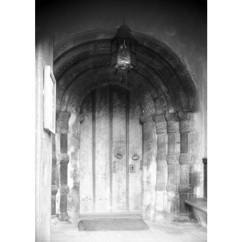
view of church exterior - south portal
Scene Description: in 1977
Copyright Statement: Image copyright © George Plunkett, 2013
Image Source: B&W photograph taken 12 June 1977 by George Plunkett [www.georgeplunkett.co.uk/Norfolk/W/Wroxham St Mary's church Norman south door [5825] 1977-06-12.jpg] [accessed 22 August 2013]
Copyright Instructions: Standing permission by Jonathan Plunkett
view of church exterior - south portal
Scene Description: in 1946
Copyright Statement: Image copyright © George Plunkett, 2013
Image Source: B&W photograph taken 22 September 1946 by George Plunkett [www.georgeplunkett.co.uk/Norfolk/W/Wroxham St Mary's church Norman south door [3641] 1946-09-22.jpg] [accessed 22 August 2013]
Copyright Instructions: Standing permission by Jonathan Plunkett
view of church exterior - southeast view
Scene Description: in 1934
Copyright Statement: Image copyright © George Plunkett, 2013
Image Source: B&W photograph taken 2 April 1934 by George Plunkett [www.georgeplunkett.co.uk/Norfolk/W/Wroxham St Mary's church from SE [0072] 1934-04-02.jpg] [accessed 22 August 2013]
Copyright Instructions: Standing permission by Jonathan Plunkett
view of church interior - nave - looking east
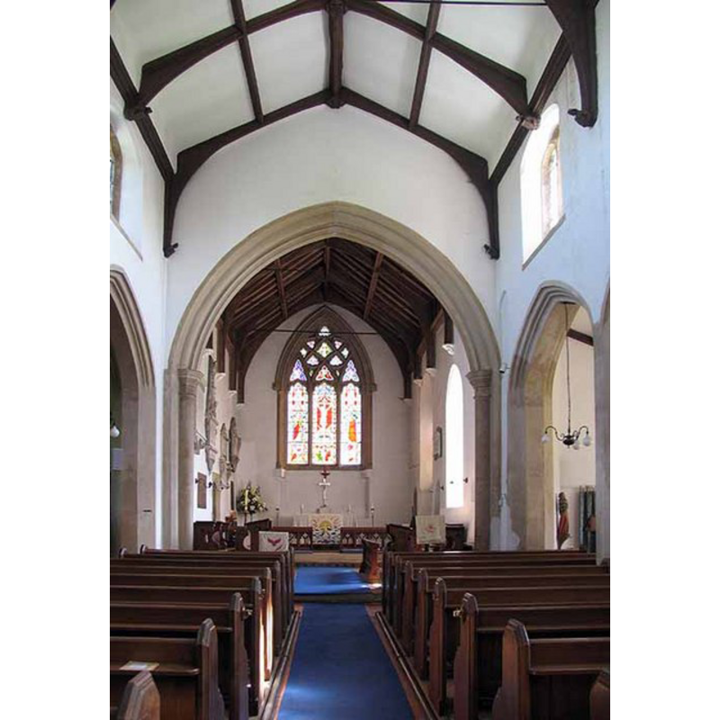
Copyright Statement: Image copyright © John Salmon, 2008
Image Source: digital photograph taken 7 May 2008 by John Salmon [www.geograph.org.uk/photo/804990] [accessed 22 August 2013]
Copyright Instructions: CC-BY-SA-3.0
design element - architectural - arcade - blind
Copyright Statement: Image copyright © Baptisteria Sacra Index, 2023
Image Source: sketch by M. Torrens based on bibliographic sources [cf. FontNotes]
Copyright Instructions: CC-BY-NC-ND-4.0
INFORMATION
Font ID: 02682WRO
Object Type: Baptismal Font1
Font Century and Period/Style: 13th - 14th century, Decorated
Church / Chapel Name: Parish Church of St. Mary the Virgin
Font Location in Church: [cf. FontNotes]
Church Patron Saint(s): St. Mary the Virgin
Church Address: St Mary's Close, Wroxham, Norfolk, NR12 8SG
Site Location: Norfolk, East Anglia, England, United Kingdom
Directions to Site: Wroxham is on the A1151 about 16 km NE of Norwich
Ecclesiastic Region: Diocese of Norwich
Historical Region: Hundred of Taverham
Additional Comments: disappeared font? (two churches noted in Domesday, one of them active 12thC through the 14thC, and still a parish church now)
Font Notes:
Click to view
There are three entries for Wroxham [variant spelling] in the Domesday survey [http://domesdaymap.co.uk/place/TG2917/wroxham/] [accessed 22 April 2014], one of which lists two churches and church lands in it. Blomefield (1805-1810) writes: "In Domesday Book, it is wrote Uroceham, and Urochesham [...] here were two churches endowed with 32 acres of land valued [...] The Church of Wroxham is dedicated to St. Mary, and was a rectory [...] In 1320, William de Cokethorp, instituted vicar". Blomefield (ibid.) makes no additional specific mention of the two churches surveyed here in Domesday, but he reports the transfer of the "the advowson of the church to the priory, and nuns of Carhou, by Norwich" by Margaret, who "married Hugh de Cressi", a noblewoman that is recorded ijn the Oxford Dictionary of National Biography [www.oxforddnb.com.myaccess.library.utoronto.ca/view/article/57614] [accessed August 22, 2013] as Margaret de Chesney, "heir to Blythburgh, Suffolk, and hereditary claimant to the shrievalty of Norfolk and the custodianship of Norwich Castle", married in 1174 Hugh de Cressy, of Norman descent and a chief administrator to king Henry II. This connexion is relevant in establishing that, even though the first recorded vicar in the church of Wroxam occurs only in 1320 [cf. supra], the church here is documented by this change of advowson ca. 1174. A font here is illustrated in the context of the church interior in Cotman (1838). Bell (1927) lists an 1839 water-colour drawing of this font by Miles Edmund Cotman in the Bulwer Collection. Ruprich-Robert (1884-1889) illustration shows a view of the later baptismal font through the Norman doorway at Wroxham: an octagonal Gothic basin with plain sides and chamfered underbowl; the base sides have blind arches; the whole is raised on a two-step platform of unequal size steps. Handsome wooden pyramidal cover, also octagonal, with finial. The present font is illustrated in Knott (2004) and it must be 19th-century, octagonal, the sides of the basin decorated with a variety of Gothic motifs, the stem with mouldings and cusped arches or windows. [NB: when was the old font shown on Cotman's 1839 illustration [cf. supra] replaced? -- we have no information on any of the fonts(?) from the original churches here].
Credit and Acknowledgements: We are grateful to Jonathan Plunkett for the photographs of this church taken by his father, George Plunkett, between 1934 and 1977
COORDINATES
UTM: 31U 391755 5840857
Latitude & Longitude (Decimal): 52.706778, 1.397835
Latitude & Longitude (DMS): 52° 42′ 24.4″ N, 1° 23′ 52.21″ E
MEDIUM AND MEASUREMENTS
Material: stone, type unknown
Font Shape: octagonal, mounted
Basin Interior Shape: round
Basin Exterior Shape: octagonal
LID INFORMATION
Date: 17th-18th century?
Material: wood
Apparatus: no
REFERENCES
- Bell, C.F., Miles Edmund Cotman (1810-1858): with a catalogue of fifty drawings by him, selected from the Bulwer Collection, London: Walker's Galleries, [1927?], p. 34
- Blomefield, Francis, An essay towards a topographical history of Norfolk, 1805-1810, vo. 10: 473-478 / [www.british-history.ac.uk/report.aspx?compid=78723] [accessed 22 August 2013]
- Cotman, John Sell, Specimens of Architectural Remains in Various Counties in England, but principally in Norfolk, London: H.G. Bohn, 1838, vol. 1: pl. XXVI
- Knott, Simon, The Norfolk Churches Site, Simon Knott, 2004. [standing permission to reproduce images received from Simon (February 2005]. URL: www.norfolkchurches.co.uk.
- Ruprich-Robert, V., Architecture normande aux XIe et XIIe siècles en Normandie et en Angleterre, Paris: Libraririe des imprimeries réunies, 1884-1889, ill. on p. [252]