Sedbergh / Sadberg / Sedberge
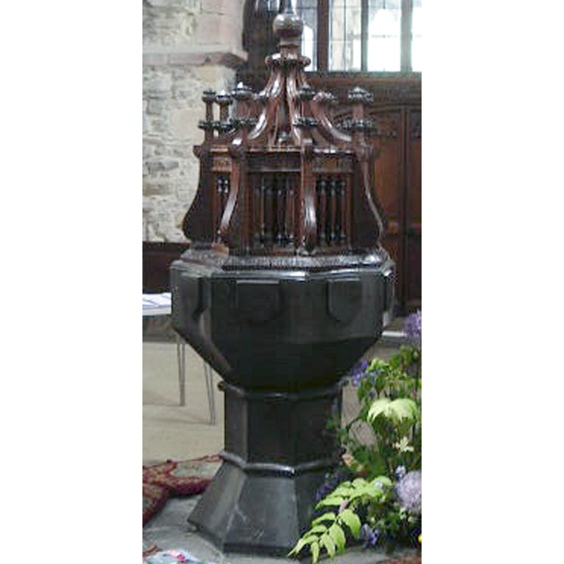
Image copyright © Alexander P Kapp, 2007
CC-BY-SA-3.0
Results: 6 records
view of font and cover
Copyright Statement: Image copyright © Alexander P Kapp, 2007
Image Source: detail of a digital photograph taken 17 May 2007 by Alexander P Knapp [www.geograph.org.uk/photo/436402] [accessed 29 October 2013]
Copyright Instructions: CC-BY-SA-3.0
symbol - shield - blank - 8
Copyright Statement: Image copyright © Alexander P Kapp, 2007
Image Source: detail of a digital photograph taken 17 May 2007 by Alexander P Knapp [www.geograph.org.uk/photo/436402] [accessed 29 October 2013]
Copyright Instructions: CC-BY-SA-3.0
view of church exterior - north view
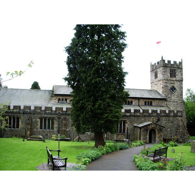
Copyright Statement: Image copyright © Alexander P Kapp, 2007
Image Source: digital photograph taken 17 May 2007 by Alexander P Knapp [www.geograph.org.uk/photo/436396] [accessed 29 October 2013]
Copyright Instructions: CC-BY-SA-3.0
view of font and cover in context
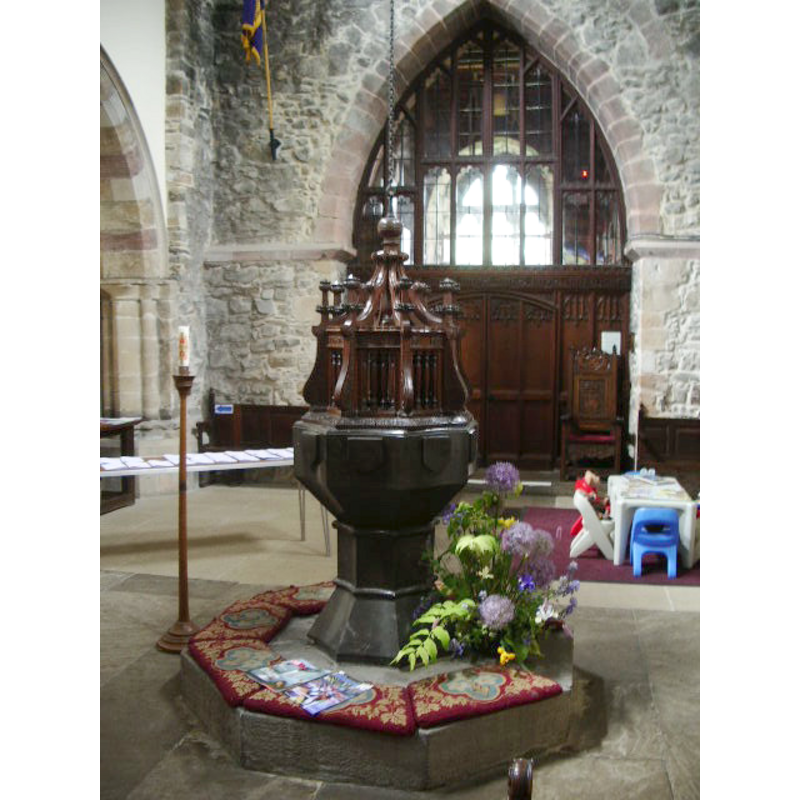
Scene Description: at the west end
Copyright Statement: Image copyright © Alexander P Kapp, 2007
Image Source: digital photograph taken 17 May 2007 by Alexander P Knapp [www.geograph.org.uk/photo/436402] [accessed 29 October 2013]
Copyright Instructions: CC-BY-SA-3.0
view of church interior - nave - looking east
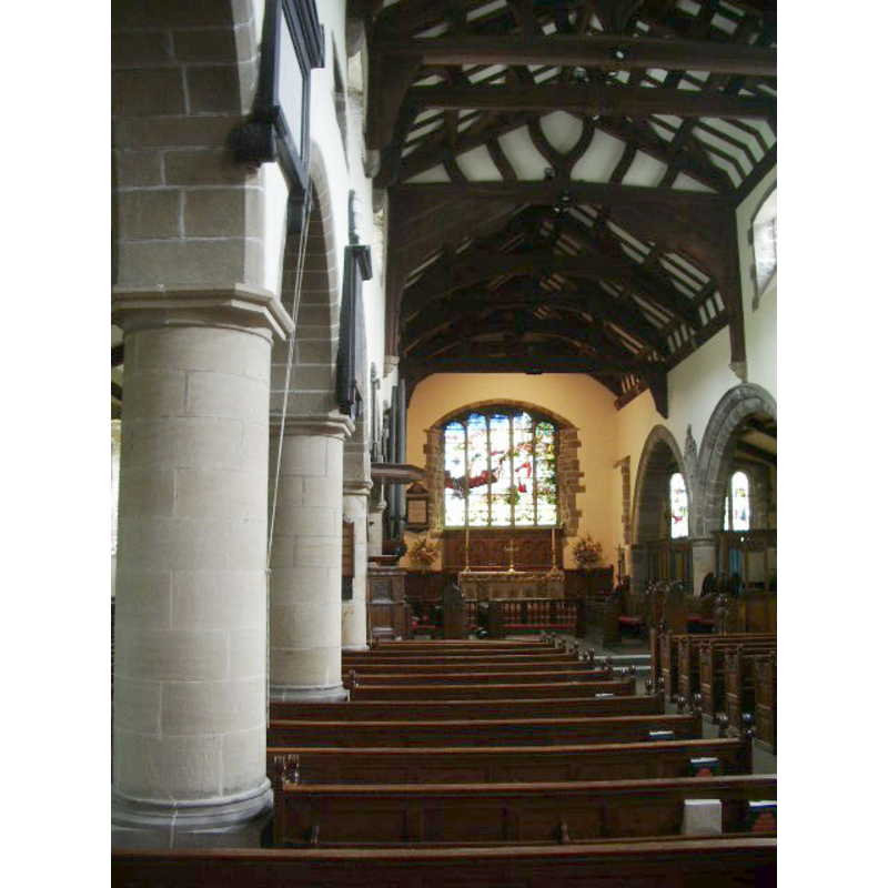
Copyright Statement: Image copyright © Alexander P Kapp, 2007
Image Source: digital photograph taken 17 May 2007 by Alexander P Knapp [www.geograph.org.uk/photo/436421] [accessed 29 October 2013]
Copyright Instructions: CC-BY-SA-3.0
design element - motifs - roll moulding - parallel - 2
Copyright Statement: Image copyright © Alexander P Kapp, 2007
Image Source: detail of a digital photograph taken 17 May 2007 by Alexander P Knapp [www.geograph.org.uk/photo/436402] [accessed 29 October 2013]
Copyright Instructions: CC-BY-SA-3.0
INFORMATION
Font ID: 02032SED
Object Type: Baptismal Font1
Font Century and Period/Style: 15th century [restored], Perpendicular [altered]
Workshop/Group/Artisan: heraldic font
Cognate Fonts: somewhat like the font at South Kilvington?
Church / Chapel Name: Parish Church of St. Andrew
Font Location in Church: Inside the church, at the W end
Church Patron Saint(s): St. Andrew
Church Address: Main St, Sedbergh LA10 5BZ, UK
Site Location: Cumbria, North West, England, United Kingdom
Directions to Site: Located 17 km E of Kendal, at the junction of the A683-A684
Ecclesiastic Region: Diocese of Carlisle
Historical Region: Wapentake of Ewecross, Hundred of Amounderness -- formerly WRYrks / Richmondshire
Additional Comments: restored font / altered font (the present font) -- disappeared font? (the one from the pre-1330 church here)
Font Notes:
Click to view
There is a multiple-place entry for Sebergh [variant spelling] in the Domesday survey [https://opendomesday.org/place/SD6592/sedbergh/] [accessed 7 February 2020] but it mentions neither cleric nor church in it. Whitaker (1823) notes that a 1330 document recorded the appropriation of the church here to the abbey of Coverham; he adds: "the present church of Sedberg, though the windows have been modernized, retains within much of the original fabric"; no font is mentioned in Whitaker. Lewis' Dictionary of 1848 reports: "The font, a beautiful specimen of Garsdale marble, has been restored." Noted in Glynne's 7 May 1862 visit to this church, (in Butler, 2007): "The font has an octagonal bowl of black marble, with concave sides charged with shields, the stem also of marble with concave sides" [NB: Glynne (ibid.) mentions a stoup near the south door but does give further details]. Listed in Cox & Harvey (1907) as a baptismal font of the Perpendicular period. The entry for this church in Historic England [Listing NGR: SD6571892077] notes: "Parish church. Mostly c1500, but incorporating fabric of various earlier periods; with major restoration 1886-7", but mentions no font in it. [NB: Sedbergh St. Gregory's is a later church of the 1860s built for the navvies during the height of the railway construction].
COORDINATES
UTM: 30U 530667 6019573
Latitude & Longitude (Decimal): 54.3231, -2.5285
Latitude & Longitude (DMS): 54° 19′ 23.16″ N, 2° 31′ 42.6″ W
MEDIUM AND MEASUREMENTS
Material: stone, marble (Garsdale marble)
Font Shape: octagonal, mounted
Basin Interior Shape: round
Basin Exterior Shape: octagonal
LID INFORMATION
Date: modern?
Material: wood, oak?
Apparatus: yes; counterweight system
Notes: octagonal structure with raised scroll ribs topped by crocketed pinnacles on the outside; ball finial; appears modern
REFERENCES
- Cox, John Charles, English Church Furniture, New York: E.P. Dutton & Co., 1907, p. 231
- Glynne, Stephen Richard, The Yorkshire notes of Sir Stephen Glynne (1825-1874), Woodbridge: The Boydell Press; Yorkshire Archaeological Society, 2007, p. 362
- Lewis, Samuel, A Topographical Dictionary of England, Comprising the Several Counties, Cities, Boroughs, Corporate and Market Towns, Parishes, Chapelries, and Townships, and the Islands of Guernsy, Jersey, and Man, with Historical and Statistical Descriptions [...], London: S. Lewis, 1831, [www.british-history.ac.uk/report.asp?compid=51262] [accessed 28 February 2007]
- Whitaker, Thomas Dunham, An history of Richmondshire, in the North Riding of the County of York [...], with illustrations by J.M.W. Turner, London: [s.n.], 1823, p. 359-362