Newbald / Niwebolt / North Newbald / North Newbould
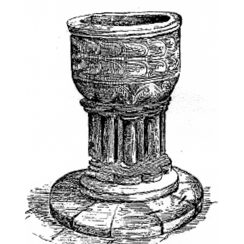
Image copyright © [in the public domain]
PD
Results: 5 records
view of font
Copyright Statement: Image copyright © [in the public domain]
Image Source: Hall (1892: 114)
Copyright Instructions: PD
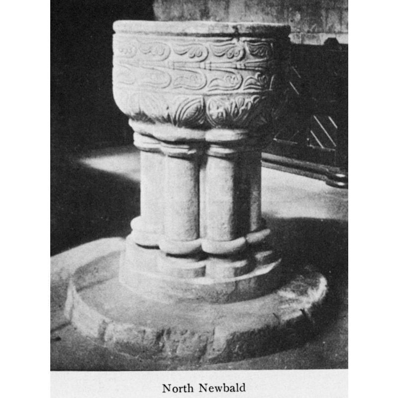
view of font
Copyright Statement: Image copyright © [in the public domain]
Image Source: digital image of an illustration in Bond (1908)
Copyright Instructions: PD
design element - motifs - foliage - acanthus
Scene Description: in three bands, all around the basin
Copyright Statement: Image copyright © [in the public domain]
Image Source: digital image of an illustration in Bond (1908)
Copyright Instructions: PD
view of church exterior
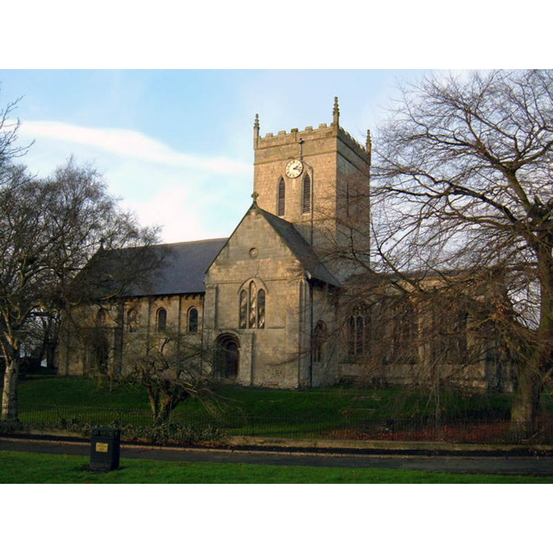
Copyright Statement: Image copyright © JThomas, 2009
Image Source: digital photograph taken 1 December 2009 by JThomas [www.geograph.org.uk/photo/1602149] [accessed 21 July 2014]
Copyright Instructions: CC-BY-SA-2.0
design element - motifs - moulding
Scene Description: forming the capitals and bases of the colonnettes
Copyright Statement: Image copyright © [in the public domain]
Image Source: digital image of an illustration in Bond (1908)
Copyright Instructions: PD
INFORMATION
Font ID: 01935NEW
Object Type: Baptismal Font1
Font Century and Period/Style: 12th - 13th century, Transitional / Early English
Church / Chapel Name: Parish Church of St. Nicholas
Font Location in Church: Inside the church
Church Patron Saint(s): St. Nicholas of Myra
Church Address: S Newbald Road, Newbald, East Riding of Yorkshire YO43 4SE
Site Location: East Riding of Yorkshire, Yorkshire and the Humber, England, United Kingdom
Directions to Site: Located off (E) of the A1034 that links the A63 with A1079, 7 km S of Market Weighton; about 40 km ESE of York, 25 km WNW of Hull.
Ecclesiastic Region: Diocese of York
Historical Region: Hundred of Cave
Additional Comments: disappeared font? (the one from the Domesday-time church here)
Font Notes:
Click to view
There is an entry for Newbald [variant spelling] in the Domesday survey [http://domesdaymap.co.uk/place/XX0000/north-and-south-newbald/] [accessed 21 July 2014], and it reports a priest and a church in it. The font here is noted in Moule (1837): "The font is circular and is enriched with a very florid moulding; the basin rests on dwarf pillars with leaved." Lewis' Dictionary of 1848 notes: "the font is early English, suriously formed and ornamented." Noted in Glynne's 14 January 1863 visit to this church (in Butler, 2007): "The font is a large circular, cup-shaped bowl on a stem. It is transitional, from Norman to Early English, and sculptured with a rude sort of foliage. The stem is composed of clustered octagonal shafts." Described and illustrated in Hall (1892): "The font is of the early English period, with clustered columns and stiff ornamental foliage round the bowl". Described in Cox & Harvey (1907) as a noteworthy example of the Early English baptismal font type [NB: C&H use the form "North Newbould"]. Described and illustrated in Bond (1908) as a beautiful Norman font of the 12th century [NB: Bond mentions its date also as late-12th or early-13th century elsewhere in the same source]. The basin is roughly hemispherical, with vertical sides, almost cylindrical, with a squarish upper rim and rounded underbowl; there is a broad band of foliage motif, stylised and "moving" in a horizontal direction; the rounded part of the underbowl has clusters of vertical leaves that create a bud-like shape and become the capitals of the engaged columns of the base; these columns have roll-mouldings at the top and bottom. The columns rest on a short round lower base, only as wide as the circle of columns, while the whole is raised on a wider plinth, also circular.
COORDINATES
UTM: 30U 656924 5965874
Latitude & Longitude (Decimal): 53.81769, -0.616214
Latitude & Longitude (DMS): 53° 49′ 3.68″ N, 0° 36′ 58.37″ W
MEDIUM AND MEASUREMENTS
Material: stone, limestone (Purbeck marble)
Font Shape: hemispheric, mounted
Basin Interior Shape: round
Basin Exterior Shape: round
REFERENCES
- Bond, Francis, Fonts and Font Covers, London: Waterstone, 1985 c1908, p. 46, 144, 206 and ill. on p. 42
- Cox, John Charles, English Church Furniture, New York: E.P. Dutton & Co., 1907, p. 229
- Friar, Stephen, The Sutton Companion to Churches, Thrupp, Stroud (Gloucs.): Sutton Publishing, 2003, p. 203
- Glynne, Stephen Richard, The Yorkshire notes of Sir Stephen Glynne (1825-1874), Woodbridge: The Boydell Press; Yorkshire Archaeological Society, 2007, p. 306
- Hall, John George, A History of South Cave, and of Other Parishes in the East Riding of the County of York, Hull: Edwin Ombler, 1892, p. 113, 114
- Lewis, Samuel, A Topographical Dictionary of England, Comprising the Several Counties, Cities, Boroughs, Corporate and Market Towns, Parishes, Chapelries, and Townships, and the Islands of Guernsy, Jersey, and Man, with Historical and Statistical Descriptions [...], London: S. Lewis, 1831, p. 374 / [www.british-history.ac.uk/report.asp?compid=51170] [accessed 21 February 2007]
- Moule, Thomas, The English counties delineated; or, A topographical description of England [...], London: George Virtue, 1837 [vol. 2], vol. 2: 424