Irthlingborough No. 1 / Artleborough / Erdeburne / Erdinburne / Hertillingborogh / Irelingburg / Irtlingburgh / Irtlibure / Irtlingburgh / Itchingborowe / Urtlingburch / Yrlingbure / Yrthingburia
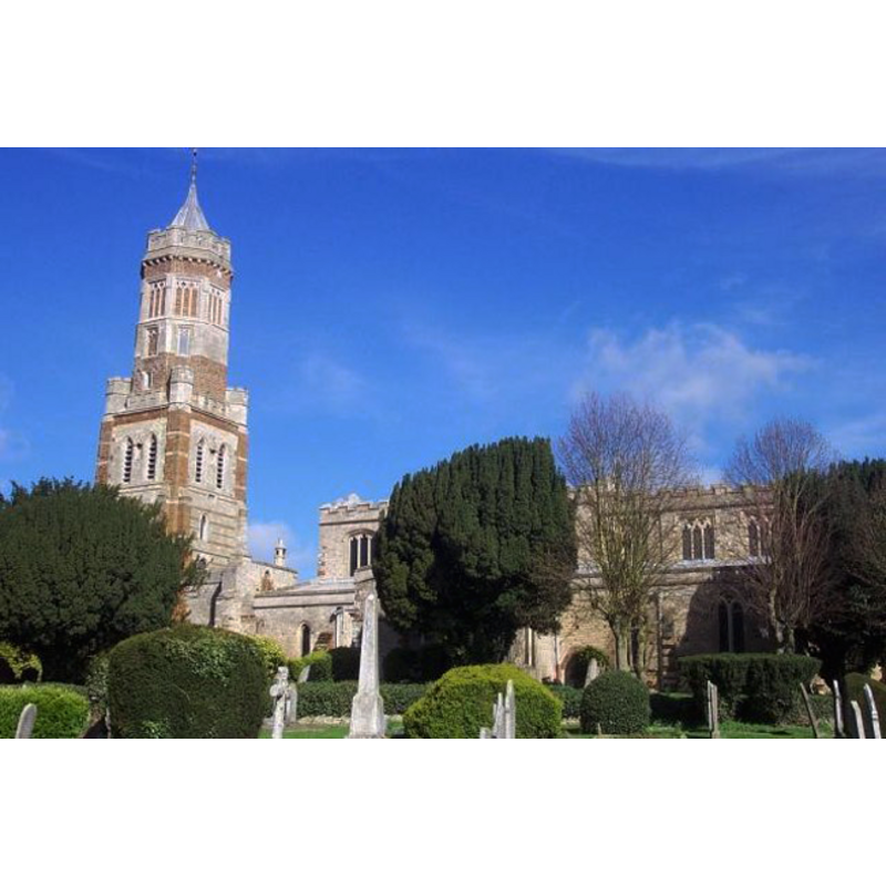
Image copyright © Geoff Pick, 2004
CC-BY-SA-3.0
Results: 4 records
B02: design element - patterns - tracery
![[cf. Font notes]](/static-50478a99ec6f36a15d6234548c59f63da52304e5/others/image_not_available.jpg)
Scene Description: [cf. Font notes]
![[cf. Font notes]](/static-50478a99ec6f36a15d6234548c59f63da52304e5/bsi-testing-site/others/image_not_available.jpg)
B03: design element - motifs - panel
Scene Description: [cf. Font notes]
R01: design element - patterns - crenellated
Scene Description: [cf. Font notes]
view of church exterior
Copyright Statement: Image copyright © Geoff Pick, 2004
Image Source: digital photograph taken 18 May 2004 by Geoff Pick [www.geograph.org.uk/photo/120204] [accessed 23 May 2012]
Copyright Instructions: CC-BY-SA-3.0
INFORMATION
Font ID: 01742IRT
Object Type: Baptismal Font1
Font Century and Period/Style: 15th century, Perpendicular
Church / Chapel Name: Parish Church of St. Peter
Font Location in Church: Inside the church
Church Patron Saint(s): St. Peter
Church Address: Church Street, Irthlingborough, Northamptonshire NN9 5SD
Site Location: Northamptonshire, East Midlands, England, United Kingdom
Directions to Site: Located on the B571, just NW of Rushden, about 30 km ENE of Northampton
Ecclesiastic Region: Diocese of Peterborough
Historical Region: Hundred of Huxloe
Additional Comments: disappeared font? [contacted the webmaster of the parish web req'g photos (email of 15 april 200)//mt
Font Notes:
Click to view
Described in Parker (1849): "The font is of the same character [i.e., Perpendicular]; octagonal, embattled, and with panelling on each face, both of the shaft and bowl." Listed in Cox & Harvey (1907) as a noteworthy baptismal font. Described in the Victoria County History (Northampton, vol. 3, 1930): "The 15th-century font has an octagonal bowl with elaborate traceried panels and embattled top moulding on a panelled stem." Mee (1945) mentions "the 15th century font" in this church. Described in Pevsner & Cherry (1973): "Perp[endicular], octagonal, with traceried panels, embattled." [NB: the fabric of the church goes back to the 12th century, but we have no information on on early baptismal font here] [cf. Index entry for Irthlingborough Nos. 2-3 for a set of two Norman stoups located at either side of the west door -- The VCH notes also "Externally, east of the doorway, is a mutilated stoup" but does indicate a date; perhaps Norman? [not listed]].
COORDINATES
UTM: 30U 662544 5799806
Latitude & Longitude (Decimal): 52.324471, -0.614845
Latitude & Longitude (DMS): 52° 19′ 28.1″ N, 0° 36′ 53.44″ W
MEDIUM AND MEASUREMENTS
Material: stone, type unknown
REFERENCES
- Victoria County History [online], University of London, 1993-. URL: https://www.british-history.ac.uk.
- Cox, John Charles, English Church Furniture, New York: E.P. Dutton & Co., 1907, p. 211
- Mee, Arthur, The King's England: Northamptonshire, country of spires and stately homes, London: Hodder & Stoughton, 1945, [http://northamptoncastle.homeip.net/northampton/books/Arthur%20Mee.htm] [accessed 25 October 2006]
- Parker, John Henry, Architectural notices of the churches of the Archdeaconry of Northampton: Deaneries of Higham Ferrers and Haddon, London; Oxford: John Henry Parker, 1849, p. 123