Ingham nr. Norwich / Hinccham / Nincham
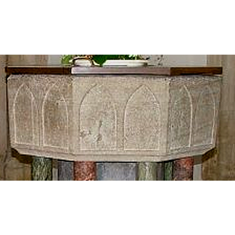
Image copyright © Simon Knott, 2006
Standing permission
Results: 5 records
view of font and cover
Scene Description: [cf. Font notes]
Copyright Statement: Image copyright © Simon Knott, 2006
Image Source: detail of a digital photograph September 2004 by Simon Knott [www.norfolkchurches.co.uk/kelling/kelling.htm] [accessed 14 February 2007]
Copyright Instructions: Standing permission
design element - architectural - arcade - blind - pointed arches - 8
Scene Description: [cf. Font notes]
Copyright Statement: Image copyright © Simon Knott, 2006
Image Source: detail of a digital photograph September 2004 by Simon Knott [www.norfolkchurches.co.uk/kelling/kelling.htm] [accessed 14 February 2007]
Copyright Instructions: Standing permission
view of church exterior - south porch
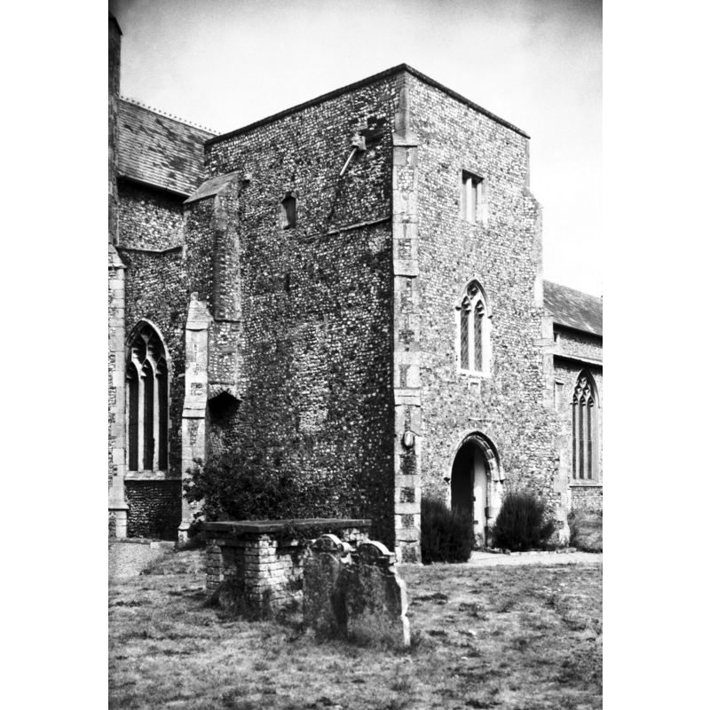
Scene Description: Photo caption: "Three storeyed porch once used as a school"
Copyright Statement: Image copyright © George Plunkett, 2014
Image Source: B&W photograph taken 18 July 1976 by George Plunkett [www.georgeplunkett.co.uk/Norfolk/I/Ingham Holy Trinity church porch from SW [5614] 1976-08-17.jpg] [accessed 15 July 2014]
Copyright Instructions: Standing permission by Jonathan Plunkett
view of church exterior - southeast view
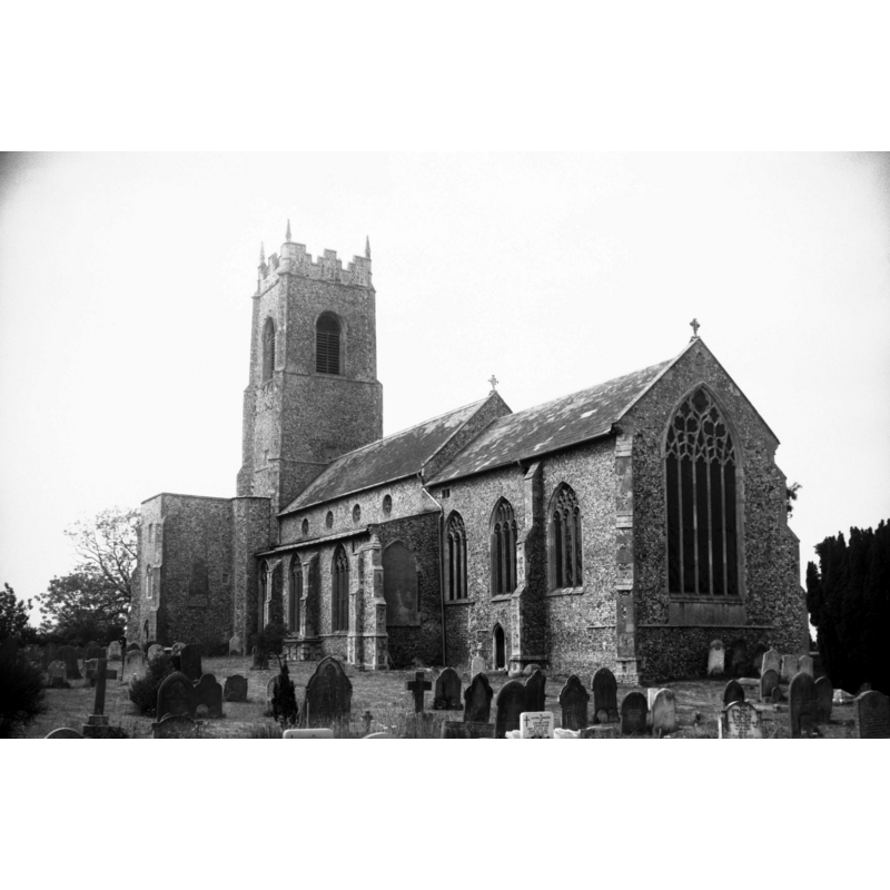
Scene Description: Photo caption: "Mainly 14-15c. Up to the time of the Dissolution this church was Collegiate and Monastic as well as parochial. Portions of the Priory remain on the north side and there was also a cloister"
Copyright Statement: Image copyright © George Plunkett, 2014
Image Source: B&W photograph taken 18 July 1976 by George Plunkett [www.georgeplunkett.co.uk/Norfolk/I/Ingham Holy Trinity church from SE [5613] 1976-08-17.jpg] [accessed 15 July 2014]
Copyright Instructions: Standing permission by Jonathan Plunkett
view of church interior - nave - looking east
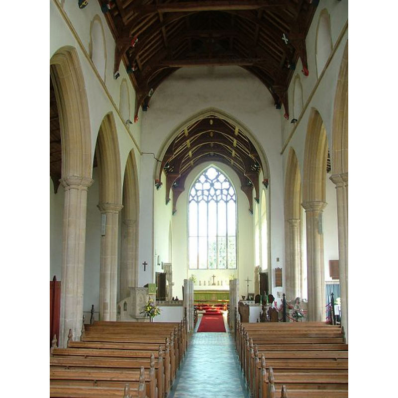
Copyright Statement: Image copyright © Simon Knott, 2004
Image Source: digital photograph September 2004 by Simon Knott [www.norfolkchurches.co.uk/kelling/kelling.htm] [accessed 15 January 2014]
Copyright Instructions: Standing permission
INFORMATION
Font ID: 01689ING
Object Type: Baptismal Font1
Font Century and Period/Style: 13th century [basin only] -- 19th century [base only] [composite font], Medieval [composite]
Cognate Fonts: Fonts at Beighton, Burnham Thorpe, etc. in Norfolk, and many such others all over England
Church / Chapel Name: Parish Church of the Holy Trinity
Font Location in Church: Inside the church
Church Patron Saint(s): The Holy Trinity
Church Notes: James (1930) describes the church as "very fine building" and describes "the rather shapeless remains of a priory founded by Sir Miles Stapleton" attached to its north side; he also informs that rubbings of its splendid brasses exist in the British Museum. There is no mention of the font in James. The Priory, or College Manor, had been founded, according to Blomefield, in 1361, and "dedicated to St. Mary and the Holy Trinity, for redemption of captives taken by the Turks [...] This priory to consist of a prior, minister, or custos, who had the care of the college, a sacrist, who had care of the parishioners, and to officiate for them; the church appropriated to the college" [NB: since this church appears to have had parochial, as well as collegiate and monastic functions, did it have a baptismal font?]
Church Address: Mill Road, Ingham, Norfolk, NR12 9AB
Site Location: Norfolk, East Anglia, England, United Kingdom
Directions to Site: Located on the B1151, 2 km E of Stalham, about 25 km ENE of Norwich
Ecclesiastic Region: Diocese of Norwich
Historical Region: Hundred of Happing
Additional Comments: altered font / composite font [cf. FontNotes] -- disappeared font? (was there ever one in the priory church here?)
Font Notes:
Click to view
This Ingham appears in three entries in the Domesday survey [http://domesdaymap.co.uk/place/TG3926/ingham/], but neither mentions a church or cleric in it. Blomefield (1805-1810) writes: "The Church is dedicated to the Holy Trinity; it was anciently a rectory, valued at 26 marks in the reign of Edward I. when the rector had a manse, and 30 acres of land [...] It consists of a nave, a north and south isle, all formerly covered with lead, and the tower is beautiful [...] Reginald le Gross occurs rector in the 14th of Edward I" [i.e., 1286], which is the earliest mention of the parish church we found. Lewis' Dictionary of 1848 reports "a Norman font" in this church. Tyrrell-Green (1928) writes: "The octagonal form persisted in fonts of the same class in the thirteenth century, with the change that in the Early English style pointed arches take the place of rounded ones in the shallow incised arcading". This font is one of them, but T-G does not mention the Victirian alterations that gave this basin a new base. Listed in Leach (1975) as a font made of Purbeck marble; "bowl probably recut; suppost 19th century". Described in Pevsner & Wilson (1997) as consisting of an octagonal Purbeck marble basin raised on a 19th-century base. Noted and illustrated in Knott (2004), who is not greatly impressed by this font: "For such a grand church there is a surprinsingly bog-standard Purbeck font, and although the Victorians had a go at making it grander, perhaps it came from somewhere else originally and Christian [i.e., Ewan Christian (1814-1895): Manxman, eminent Victorian architect and president of RIBA; directed the restoration of Holy Trinity's in the 1870s] installed it here."
Credit and Acknowledgements: We are grateful to Simon Knott, of www.norfolkchurches.co.uk, for his photographs of this church and font; we are also grateful to Jonathan Plunkett for the photographs of this church taken by his father, George Plunkett, in July 1976
COORDINATES
UTM: 31U 401702 5848761
Latitude & Longitude (Decimal): 52.779705, 1.542645
Latitude & Longitude (DMS): 52° 46′ 46.94″ N, 1° 32′ 33.52″ E
MEDIUM AND MEASUREMENTS
Material: stone, type unknown
Font Shape: octagonal, mounted
Basin Interior Shape: round
Basin Exterior Shape: octagonal
LID INFORMATION
Date: modern
Material: wood, oak?
Apparatus: no
Notes: octagonal and flat; modern
REFERENCES
- Blomefield, Francis, An essay towards a topographical history of Norfolk, 1805-1810, vol. 9: 316-327 / [www.british-history.ac.uk/report.aspx?compid=78553] [accessed 15 January 2014]
- Knott, Simon, The Norfolk Churches Site, Simon Knott, 2004. [standing permission to reproduce images received from Simon (February 2005]. URL: www.norfolkchurches.co.uk.
- Leach, Rosemary, A Investigation into the use of Purbeck Marble in Medieval England, Hartlepool: E.W. Harrisons & Sons, 1975, p. 77
- Lewis, Samuel, A Topographical Dictionary of England, Comprising the Several Counties, Cities, Boroughs, Corporate and Market Towns, Parishes, Chapelries, and Townships, and the Islands of Guernsy, Jersey, and Man, with Historical and Statistical Descriptions [...], London: S. Lewis, 1831, [www.british-history.ac.uk/report.asp?compid=51062] [accessed 14 February 2007]
- Pevsner, Nikolaus, Norfolk 1: Norwich and North-East [2nd ed.], Harmondsworth: Penguin Books, 1997, p. 575
- Tyrrell-Green, E., Baptismal Fonts Classified and Illustrated, London: Society for Promoting Christian Knowledge: The Macmillan Co., 1928, p. 29, 88