Weston Underwood / Weston-by-Launden / Weston-by-Olney / Weston Underwode / Westone
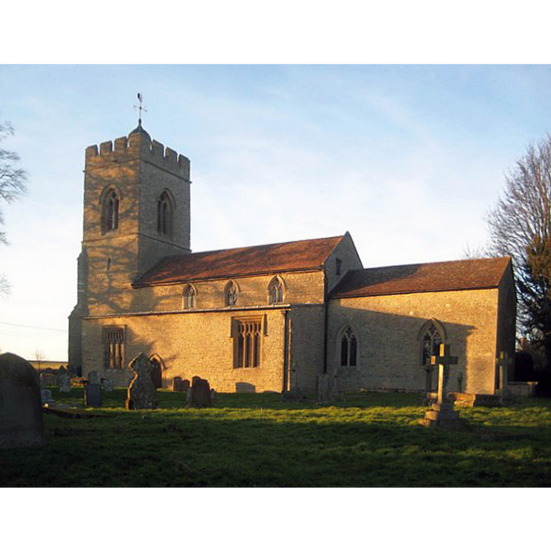
Image copyright © Nigel Cox, 2015
CC-BY-SA-2.0
Results: 9 records
view of church exterior - southeast view
Scene Description: Source caption: "Weston Underwood: Church of St Lawrence. Caught in the low winter setting sun the church is Grade I Listed with the earliest parts dating from the 12th century."
Copyright Statement: Image copyright © Nigel Cox, 2015
Image Source: digital photograph taken 8 February 2015 by Nigel Cox [www.geograph.org.uk/photo/4344066] [accessed 8 March 2016]
Copyright Instructions: CC-BY-SA-2.0
symbol - shield - coat of arms - Pever
![[cf. Font notes]](/static-50478a99ec6f36a15d6234548c59f63da52304e5/others/image_not_available.jpg)
Scene Description: [cf. Font notes]
![[cf. Font notes]](/static-50478a99ec6f36a15d6234548c59f63da52304e5/bsi-testing-site/others/image_not_available.jpg)
symbol - shield - coat of arms - unidentified
Scene Description: [cf. Font notes]
symbol - shield - coat of arms - unidentified
Scene Description: [cf. Font notes]
symbol - shield - coat of arms - unidentified
Scene Description: [cf. Font notes]
symbol - shield - coat of arms - unidentified
Scene Description: [cf. Font notes]
symbol - shield - coat of arms - Olney
Scene Description: [cf. Font notes]
symbol - shield - coat of arms - Hussey
Scene Description: [cf. Font notes]
symbol - shield - coat of arms - Hungerford
Scene Description: [cf. Font notes]
INFORMATION
Font ID: 01360WES
Object Type: Baptismal Font1
Font Century and Period/Style: 13th century / 15th century, Early English? / Perpendicular?
Workshop/Group/Artisan: heraldic font
Church / Chapel Name: Parish Church of St. Lawrence [aka St Laurence]
Font Location in Church: Inside the church
Church Patron Saint(s): St. Lawrence [aka Laurence]
Church Address: High Street, Weston Underwood, Milton Keynes MK46 5JS
Site Location: Buckinghamshire, South East, England, United Kingdom
Directions to Site: Located off the A509, 2 km W of Olney, 8 km N of Newport Pagnell
Ecclesiastic Region: Diocese of Oxford
Historical Region: Hundred of Bunsty [in Domesday] -- Hundred of Newport
Additional Comments: disappeared font? (the one from the original 12thC church here)
Font Notes:
Click to view
There are three entries for this Weston [Underwood] in the Domesday survey [http://opendomesday.org/place/SP8650/weston-underwood/] [accessed 8 March 2016], none of which mentions cleric or church in it. Noted in Parker (1850) and in Cox & Harvey (1907) as a baptismal font of the Early English period. Sheahan (1862), however, describes it as "plain Early English". The Victoria County History notes: "The nave probably incorporates part of the walling of a 12th century church to which aisles were added about the middle of the 13th century. The chancel arch was rebuilt in the first half of the 14th century, but by the middle of the century the condition of the fabric must have become very unsatisfactory, as its restoration was undertaken by John Olney, lord of the manor, about 1368, in which year the church was refounded [...] The font is of the 15th century and has an elaborate octagonal tapering bowl. In each face of the octagonal stem is a trefoiled ogee-headed panel containing a shield of arms: (I) a cheveron with three fleurs de lis thereon, for Pever; (2) a chief indented; (3) an embattled fesse between six crosslets fitchy with three crescents on the fesse, for Olney; (4) a plain fesse; (5) an embattled fesse with three crosslets fitchy in the chief; (6) a plain cross, for Hussey; (7) an embattled fesse with a pierced molet thereon; (8) two bars with three roundels in chief, for Hungerford. The pyramidal wooden cover is of the 17th century."
COORDINATES
UTM: 30U 654702 5779512
Latitude & Longitude (Decimal): 52.144426, -0.739105
Latitude & Longitude (DMS): 52° 8′ 39.94″ N, 0° 44′ 20.78″ W
MEDIUM AND MEASUREMENTS
Material: stone, type unknown
Font Shape: octagonal, mounted
Basin Interior Shape: round
Basin Exterior Shape: octagonal
LID INFORMATION
Date: 17th-century
Material: wood
Notes: [cf. FontNotes]
REFERENCES
- Victoria County History [online], University of London, 1993-. URL: https://www.british-history.ac.uk.
- Cox, John Charles, English Church Furniture, New York: E.P. Dutton & Co., 1907, p. 187
- Parker, John Henry, The Ecclesiastical and architectural topography of England: Oxfordshire, Oxford, London: Published under the sanction of the Central Commitee of the Archaeological Institute of Great Britain and Ireland [by] John Henry Parker, 1850, [entry no.] 139
- Sheahan, James Joseph, History and topography of Buckinghamshire, comprising a general survey of the county, preceded by an epitome of the early history of Great Britain, London; Pontefract: Longman, Green, Longman, and Roberts; William Edward Bonas [...], 1862, p. 641