Leighton Buzzard / Beaudesert / Busard / Buzzard / Layton / Lecton / Leghton / Lehton / Leighton Busard / Leighton Linslade / Lenton / Lestone [Domesday] / Lygetune / Leyghton
![Main image for Leighton Buzzard / Beaudesert / Busard / Buzzard / Layton / Lecton / Leghton / Lehton / Leighton Busard / Leighton Linslade / Lenton / Lestone [Domesday] / Lygetune / Leyghton](/static-50478a99ec6f36a15d6234548c59f63da52304e5/compressed/1050204016_compressed.png)
Image copyright © [in the public domain]
PD
Results: 3 records
view of font
Copyright Statement: Image copyright © [in the public domain]
Image Source: Lysons (1806-1833)
Copyright Instructions: PD
view of church exterior - east view
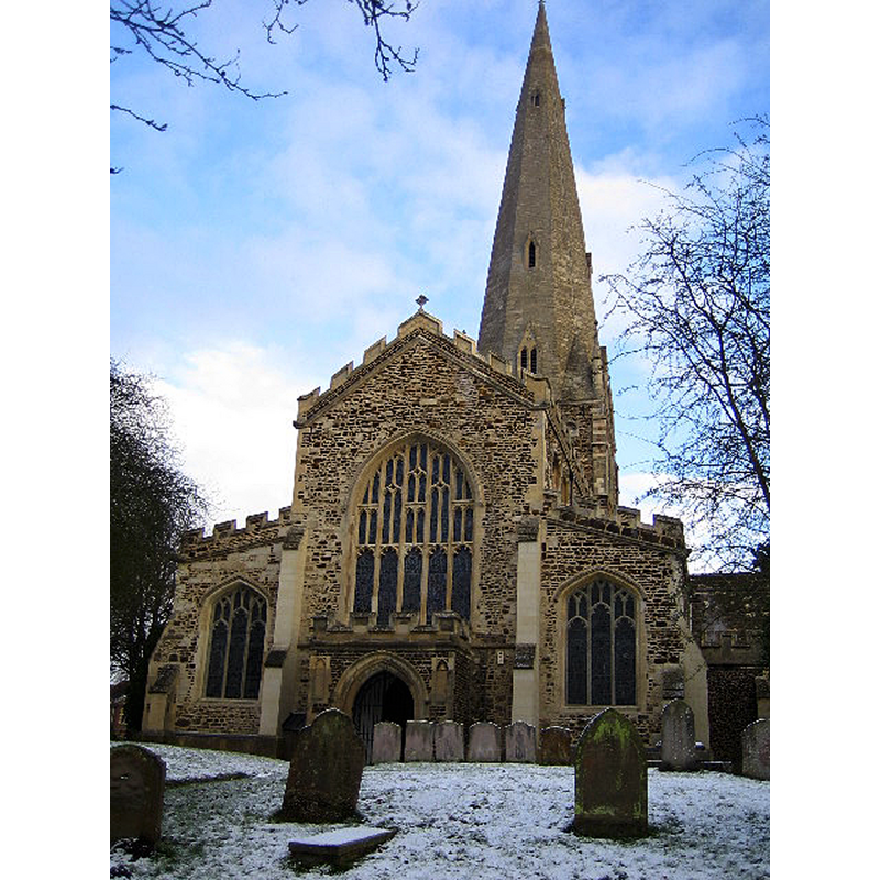
Scene Description: Source caption: "A church has stood on the site of the present building in Leighton Buzzard for more than 1,000 years. Today's church dates from 1277 and has a 60 metre high broach spire on a squat tower, which is a prominent landmark in the locality. Inside it boasts a magnificent 15th Century roof adorned with angels and saints contrasting with 25 ferocious gargoyles around the outside. The Church was severely damaged by fire in 1985. The fire happened just as a restoration programme was nearing completion. It destroyed most of the nave and chancel roofs and caused serious structural damage to the tower, spire, and the vestry areas and a number of the windows were damaged beyond repair. The ring of ten bells was lost as were both the organs. The total cost of the damage exceeded £1.5 million pounds."
Copyright Statement: Image copyright © Nigel Cox, 2015
Image Source: digital photograph taken 28 December 2005 by Nigel Cox [www.geograph.org.uk/photo/96771] [accessed 22 September 2015]
Copyright Instructions: CC-BY-SA-2.0
design element - motifs - moulding
Scene Description: at the capitals and bases of the five columns that make up the base
Copyright Statement: Image copyright © [in the public domain]
Image Source: Lysons (1806-1833)
Copyright Instructions: PD
INFORMATION
Font ID: 01254LEI
Object Type: Baptismal Font1
Font Century and Period/Style: 13th century, Early English
Cognate Fonts: Eaton Bray and Holwell, in the same county; also Belaugh, in Norfolk
Church / Chapel Name: Parish Church of All Saints
Font Location in Church: Inside the church
Church Patron Saint(s): All Saints
Church Address: Church Square, Leighton Buzzard, Bedfordshire, LU7 1AE
Site Location: Bedfordshire, East, England, United Kingdom
Directions to Site: Located 10-12 km W of Luton
Ecclesiastic Region: Diocese of St. Albans [medieval diocese: Dorchester]
Historical Region: Hundred of Manshead
Additional Comments: disappeared font? (the one from the Domesday-time church here)
Font Notes:
Click to view
There are three entries for Leighton [Buzzard] [variant spelling] in the Domesday survey [http://opendomesday.org/place/SP9125/leighton-buzzard/] [accessed 22 September 2015], one of which, in the lordship of the Bishop of Lincoln in both 1066 and 1086, mentions a church and four hides of church lands in it. Lysons (1806-1833) note and illustrate the font here as one of a group of circular fonts: “in the shape of a bason standing on five pillars, some of which have capitals of foliage” [Eaton Bray and Holwell are two others in this group]. Paley (1844) mentions this font in his entry for the similar font at Belaugh, Norfolk, although he dates the latter to an earlier, Transitional, period. Listed in Cox & Harvey (1907) as a baptismal font of the Early English period. Bond (1908) describes it as one of a group of "fonts with convex bowls supported by one stout central column and four corner shafts"; he later describes them as a "beautiful class of cup fonts" (ibid.). The Victoria County History (Bedfordshire, vol. 3, 1912) notes: "There was a church attached to the royal manor of Leighton at the Domesday Survey [...] The [present] church was built in the second half of the 13th century [...] At the west end of the nave is a 13th-century font with a round bowl on a central and four-angle shaft." Listed in Tyrrell-Green (1928) as a font of Norman design but dated to the Early English period, the base made up of "columns with circular abacus and with moulded capitals and bases".
Credit and Acknowledgements: We are grateful to the Thomas Fisher Rare Books Library for access to the copy of Lysons’ Magna Britannia, and to Jim Ingram, of the Preservation Services, Robarts Library, for the digital imaging of Lysons’ illustrations.
COORDINATES
UTM: 30U 660579 5754127
Latitude & Longitude (Decimal): 51.9147, -0.6652
Latitude & Longitude (DMS): 51° 54′ 52.92″ N, 0° 39′ 54.72″ W
MEDIUM AND MEASUREMENTS
Material: stone, limestone (Purbeck marble)
Font Shape: hemispheric, mounted
Basin Interior Shape: round
Basin Exterior Shape: round
LID INFORMATION
Date: modern?
Material: wood and metal, oak
Apparatus: no
Notes: octagonal wooden platform with raised scroll metalwork
REFERENCES
- Victoria County History [online], University of London, 1993-. URL: https://www.british-history.ac.uk.
- Bond, Francis, Fonts and Font Covers, London: Waterstone, 1985 c1908, p. 57, 209
- Cox, John Charles, English Church Furniture, New York: E.P. Dutton & Co., 1907, p. 186
- Friar, Stephen, The Sutton Companion to Churches, Thrupp, Stroud (Gloucs.): Sutton Publishing, 2003, p. 203
- Lysons, Daniel, Magna Britannia, being a concise topographical account of the several counties of Great Britain, London: Printed for T. Cadell and W. Davies, 1806-1822, vol. I: p. 31-32 and pl.
- Paley, Frederick Apthorp, Illustrations of Baptismal Fonts, London, UK: John van Voorst, 1844, unpaged
- Pevsner, Nikolaus, Bedfordshire and the County of Huntingdon and Peterborough, Harmondsworth: Penguin, 1968, p. 107
- Tyrrell-Green, E., Baptismal Fonts Classified and Illustrated, London: Society for Promoting Christian Knowledge: The Macmillan Co., 1928, p. 28, 90