Mortlake / Mortelaga / Mortelage / Mortelak / Mortelake
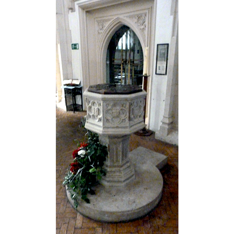
Image copyright © Bob Jones and The Lost City of London, 2016
No known copyright restriction / Fair Dealing
Results: 10 records
view of font and cover
Copyright Statement: Image copyright © Bob Jones and The Lost City of London, 2016
Image Source: digital photograph by Bob Jones in The Lost City of London [http://lostcityoflondon.co.uk/2016/01/26/mortlake/] [accessed 9 March 2016]
Copyright Instructions: No known copyright restriction / Fair Dealing
symbol - shield - coat of arms - Archbishop Bourchier (1406-1486) - in a square flower
!["a cross engrailed between four water-bougets", on the northeast side of the font [cf. FontNotes] -- seen here on the right](/static-50478a99ec6f36a15d6234548c59f63da52304e5/compressed/1160310008_compressed.png)
Scene Description: "a cross engrailed between four water-bougets", on the northeast side of the font [cf. FontNotes] -- seen here on the right
Copyright Statement: Image copyright © Parish of St Mary the Virgin, Mortlake, 2016
Image Source: digital photograph in the St Mary the Virgin, Mortlake, site [http://stmarymortlake.org.uk/life-events/baptisms/] [accessed 9 March 2016]
Copyright Instructions: No known copyright restriction / Fair Dealing
symbol - shield - coat of arms - Bourchier knot
Scene Description: on the east side of the basin [cf. FontNotes] -- seen here on the left
Copyright Statement: Image copyright © Parish of St Mary the Virgin, Mortlake, 2016
Image Source: digital photograph in the St Mary the Virgin, Mortlake, site [http://stmarymortlake.org.uk/life-events/baptisms/] [accessed 9 March 2016]
Copyright Instructions: No known copyright restriction / Fair Dealing
view of church exterior - south view
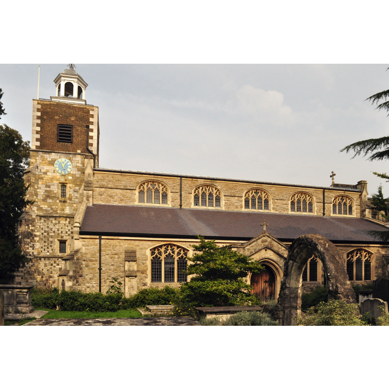
Copyright Statement: Image copyright © Mightyhansa, 2013
Image Source: digital photograph taken 25 September 2013 by Mightyhansa [https://commons.wikimedia.org/wiki/File:St_Mary_the_Virgin_Mortlake_South_view.JPG] [accessed 9 March 2016]
Copyright Instructions: CC-BY-SA-3.0
symbol - shield - letter T - crowned
![on the north side of the basin [cf. FontNotes]](/static-50478a99ec6f36a15d6234548c59f63da52304e5/others/image_not_available.jpg)
Scene Description: on the north side of the basin [cf. FontNotes]
![on the north side of the basin [cf. FontNotes]](/static-50478a99ec6f36a15d6234548c59f63da52304e5/bsi-testing-site/others/image_not_available.jpg)
animal - bird
Scene Description: "a square bird design", on the northwest side of the basin [cf. FontNotes]
Christ - Agnus Dei?
Scene Description: "a paschal lamb", on the west side of the basin [cf. FontNotes]
design element - motifs - floral - square flower
Scene Description: on the southwest of the basin [cf. FontNotes]
symbol - shield - coat of arms - See of Canterbury
Scene Description: on the south side of the basin [cf. FontNotes]
design element - motifs - floral - rose
Scene Description: on the southwest side of the basin [cf. FontNotes]
INFORMATION
Font ID: 01181MOR
Object Type: Baptismal Font1
Font Century and Period/Style: 15th century, Perpendicular
Workshop/Group/Artisan: heraldic font
Cognate Fonts: similarities with the fonts at Mitcham and Morden, also in Surrey
Church / Chapel Name: Parish Church of St. Mary the Virgin
Font Location in Church: Inside the church
Church Patron Saint(s): St. Mary the Virgin
Church Address: Mortlake High St, London SW14 8JA, United Kingdom
Site Location: Greater London, South East, England, United Kingdom
Directions to Site: Located by the S Circular Rd and the B251 crossroads, S of the Thames, W of Barnes and Putney, just NE of Richmond Park
Ecclesiastic Region: Diocese of Southwark
Historical Region: Hundred of Brixton -- formerly Surrey
Font Notes:
Click to view
There is an entry for Mortlake [variant spelling] in the Domesday survey [http://opendomesday.org/place/TQ2075/mortlake/] [accessed 9 March 2016]; it reports a church in it. Illustrated with an engraving in Manning and Bray (1804). Lewis' Dictionary of 1848 notes: "The font, ornamented with rich tracery, was the gift of Archbishop Bourchier". Brayley (1850) notes that Domesday (1086) reports a church in 'Mortlage' and a font in the present church: "The font, which is octagonal, and of stone, was probably given by [...] as it includes his arms". Described in Cox & Harvey (1907) as a baptismal font of the 15th century, the Perpendicular period, ornamented with "the arms of Archbishop Bruchier (1454-81)" [NB: Archbishop (Thomas) Bourchier, (1406-1486), installed as Archbishop of Canterbury in 1454]. The Victoria County History (Surrey, vol. 4, 1912) appears to ignore the Domesday record and notes: "The first church was founded in 1348 [...] and stood to the west of the present building. [...] The font dates from the 15th century and was the gift of Archbishop Bourchier. It has an octagonal bowl and stem with traceried sides; on the quatrefoil panels of the bowl are shields with arms and other devices as follows: east, shield with the Bourchier knot; north-east, a square flower in which is a shield of the arms of Bourchier, a cross engrailed between four water-bougets; north, a shield with a device of a crowned T; north-west, a square bird design; west, a paschal lamb; south-west, square flower; south, arms of the see of Canterbury; southwest, a rose."
COORDINATES
UTM: 30U 690191 5705594
Latitude & Longitude (Decimal): 51.4695, -0.2616
Latitude & Longitude (DMS): 51° 28′ 10.2″ N, 0° 15′ 41.76″ W
MEDIUM AND MEASUREMENTS
Material: stone, type unknown
Font Shape: octagonal, mounted
Basin Interior Shape: round
Basin Exterior Shape: octagonal
Drainage Notes: lead-lined
REFERENCES
- Victoria County History [online], University of London, 1993-. URL: https://www.british-history.ac.uk.
- Brayley, Edward Wedlake, A topographical history of Surrey, London: G. Willis, 1850, vol. 3: 466
- Cox, John Charles, English Church Furniture, New York: E.P. Dutton & Co., 1907, p. 170, 221, 222
- Lewis, Samuel, A Topographical Dictionary of England, Comprising the Several Counties, Cities, Boroughs, Corporate and Market Towns, Parishes, Chapelries, and Townships, and the Islands of Guernsy, Jersey, and Man, with Historical and Statistical Descriptions [...], London: S. Lewis, 1831, p. 345-350 / [www.british-history.ac.uk/topographical-dict/england/pp345-350] [accessed 9 March 2016]