Lambeth / Lambehide / Lambehitha / Lameham / Lamehei / Lamhea / Lamheth / Lanchei
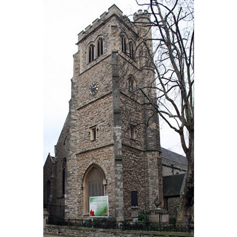
Image copyright © Richard Croft, 2007
CC-BY-SA-2.0
Results: 2 records
view of church exterior - tower
Scene Description: Source caption: St.Mary-at-Lambeth church tower. There has been a church on this site since 1062, the tower built of ragstone with diagonal buttresses dates from 1370 with top tier renewed in 1834. After some lean years it was saved from demolition in 1979 by the Tradescant Trust and became the Museum of Garden History."
Copyright Statement: Image copyright © Richard Croft, 2007
Image Source: digital photograph taken 19 February 2007 by Richard Croft [www.geograph.org.uk/photo/343540] [accessed 8 March 2016]
Copyright Instructions: CC-BY-SA-2.0
view of church interior - detail
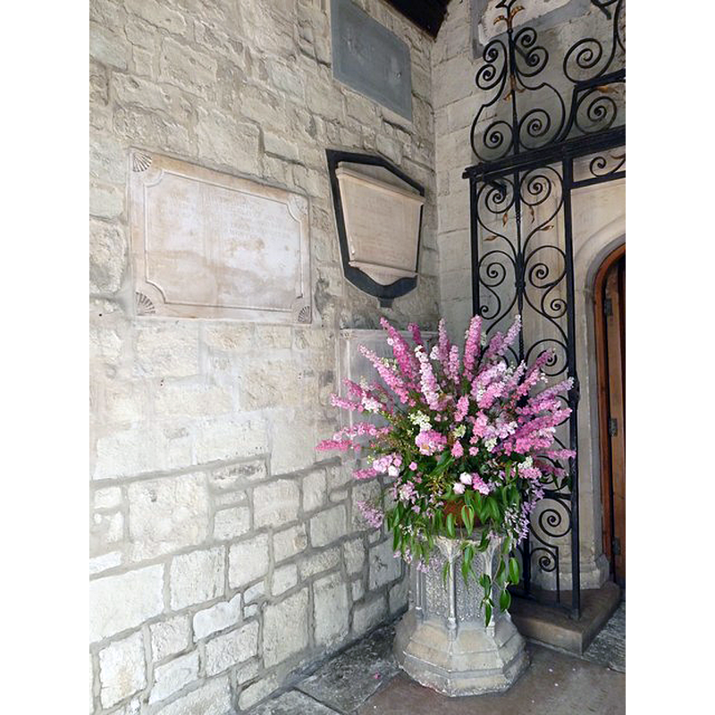
Scene Description: Is this one of the later fonts?
Copyright Statement: Image copyright © Basher Eyre, 2010
Image Source: digital photograph taken 10 July 2010 by Basher Eyre [www.geograph.org.uk/photo/1995412] [accessed 8 March 2016]
Copyright Instructions: CC-BY-SA-2.0
INFORMATION
Font ID: 01100LAM
Object Type: Baptismal Font1
Font Century and Period/Style: 10th - 11th century, Pre-Conquest
Church / Chapel Name: Church of St. Mary at Lambeth [redundant since 1972]
Font Location in Church: [cf. FontNotes]
Church Patron Saint(s): St. Mary the Virgin
Church Notes: wooden church built here by Goda, sister of Edward the Confessor, in 1062; soon thereafter re-built in stone
Church Address: 5 A3036, Lambeth, Greater London SE1 7JY, United Kingdom
Site Location: Greater London, South East, England, United Kingdom
Directions to Site: Located in central London, 1 mile S of Charing Cross
Ecclesiastic Region: Diocese of Southwark [formerly in the diocese of Rochester; originally in the diocese of Winchester]
Historical Region: Hundred of Brixton -- formerly in Surrey
Additional Comments: disappeared font / painted font (the medieval font here)
Font Notes:
Click to view
There are two entries for Lambeth in the Domesday survey [http://opendomesday.org/place/TQ3079/lambeth/] [accessed 8 March 2016], one of which reports a church in it. The Survey of London (1951) [www.british-history.ac.uk/survey-london/vol23/pp104-117] [accessed 8 March 2016] notes: "The Church of St. Mary, Lambeth [...] was for many centuries almost an adjunct of the palace [...] From the entry in Domesday Book we know that there was a church dedicated to St. Mary in Lambeth before the Norman Conquest and that it belonged to the Countess Goda, sister to King Edward the Confessor. [...] Of the mediaeval church, only the tower now survives. [...] The mediaeval font was painted and lined with lead. [...] It was replaced in 1615 by a marble font supported on an octagonal pillar with a cover and enclosure of wood, presented by John Hart, gentleman. In the time of Nichols (1786), the canopy was “handsomely painted with the text round the edge ‘Suffer the little children to come unto me and forbid them not; for of such is the Kingdom of God.’ ” [...] This font was removed to Holy Trinity Church, Carlisle Lane, in 1851 [...]; it was replaced by the present elaborate font, carved by G. P. White, when the church was rebuilt. This is wearing badly. Four panels are filled with the names and emblems of the four evangelists, while in the other four the subjects depicted are, The Deluge, the Israelites crossing the Red Sea, Christ blessing the children, and the Baptism of Christ. The font for total immersion is below the level of the church and is approached by two flights of marble steps. It was installed by John Andrewes Reeve (rector, 1894–1903) in memory of Archbishop Benson." The Victoria County History (Surrey, vol. 4, 1912) notes: "The advowson of the church mentioned in the Domesday Survey belonged with the manor to the Prior of St. Andrew's, Rochester. Since the exchange of lands in 1197 it has always belonged to the Archbishops of Canterbury. [...] The only original portion of the structure of the church of ST. MARY [...] that now remains above the foundations is the tower, which appears to date from the latter half of the 15th century"; no font mentioned in the VCH entry.
COORDINATES
UTM: 30U 699926 5708832
Latitude & Longitude (Decimal): 51.495221, -0.119781
Latitude & Longitude (DMS): 51° 29′ 42.8″ N, 0° 7′ 11.21″ W
MEDIUM AND MEASUREMENTS
Material: stone, type unknown
Drainage Notes: lead-lined [cf. FontNotes]
REFERENCES
- Victoria County History [online], University of London, 1993-. URL: https://www.british-history.ac.uk.
- Cox, John Charles J., English Church Fittings Furniture and Accessories, London: B.T. Batsford, 1922, p. 98