Notgrove / Nategraue
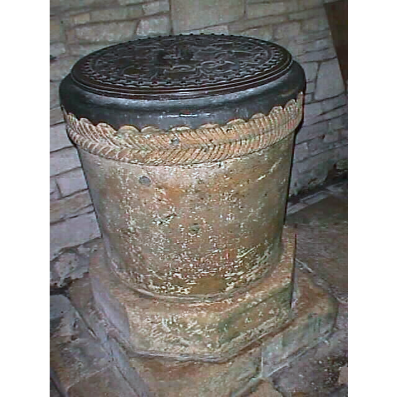
Image copyright © John Wilkes, 2007
Standing permission
Results: 5 records
view of font and cover
Copyright Statement: Image copyright © John Wilkes, 2007
Image Source: digital photograph by John Wilkes, March 2007 [www.allthecotswolds.com]
Copyright Instructions: Standing permission
design element - motifs - rope moulding - parallel - opposed thread directions
Copyright Statement: Image copyright © John Wilkes, 2007
Image Source: digital photograph by John Wilkes, March 2007 [www.allthecotswolds.com]
Copyright Instructions: Standing permission
view of church exterior - southeast view
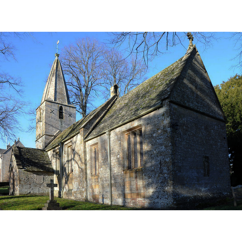
Copyright Statement: Image copyright © Philip Halling, 2013
Image Source: digital photograph taken 29 October 2013 by Philip Halling [www.geograph.org.uk/photo/3808498] [accessed 7 February 2019]
Copyright Instructions: CC-BY-SA-2.0
view of church exterior - north view
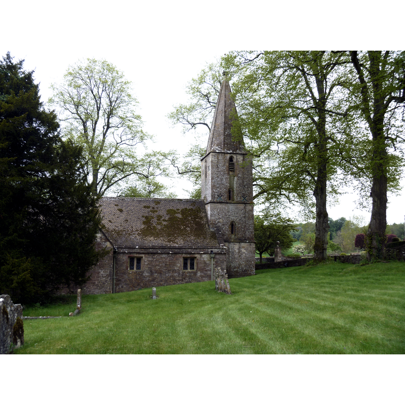
Scene Description: Source caption: "The church of St Bartholomew dates back to the 12th century. Restored in 1873".
Copyright Statement: Image copyright © Michael Dibb, 2012
Image Source: digital photograph taken 20 May 2012 by Michael Dibb [www.geograph.org.uk/photo/3021138] [accessed 7 February 2019]
Copyright Instructions: CC-BY-SA-2.0
view of church exterior - detail
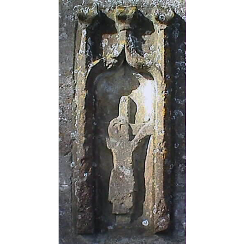
Scene Description: claimed to be a Saxon Crucifixion
Copyright Statement: Image copyright © John Wilkes, 2007
Image Source: digital photograph by John Wilkes, March 2007 [www.allthecotswolds.com]
Copyright Instructions: Standing permission
INFORMATION
Font ID: 01033NOT
Object Type: Baptismal Font1
Font Century and Period/Style: 12th century, Late Norman
Cognate Fonts: [cf. FontNotes]
Church / Chapel Name: Parish Church of St. Bartholomew [formerly St. Mary's]
Font Location in Church: Inside the church
Church Patron Saint(s): St. Bartholomew [formerly dedicated to St. Mary]
Church Notes: "was called St. Mary's in 1494 [...] but its dedication was to ST. BARTHOLOMEW in the early 18th century and later. [...] Part of the fabric, including the nave arcade, dates from the 12th century, but the church was extensively remodelled in the 14th century" [cf. VCH entry in FontNotes]
Church Address: Notgrove, Gloucestershire, GL54 3BT
Site Location: Gloucestershire, South West, England, United Kingdom
Directions to Site: Located just S of the A436, 10 km SW of Stow-on-the-Wold, 17 km E of Cheltenham
Ecclesiastic Region: Diocese of Gloucester
Historical Region: Hundred of Bradley -- Hundred of Waxcrescumbe [in Domesday]
Additional Comments: disappeared font? (the one from the liekly Domesday-time church here)
Font Notes:
Click to view
There is an entry for Notgrove [variant spelling] in the Domesday survey [https://opendomesday.org/place/SP1120/notgrove/] [accessed 7 February 2019]; it reports "0.5 church lands" but not a church in it, though there probaly was one there. Listed in Tyrrell-Green (1928) as a tub-shaped baptismal font of the Norman period ornamented with a rope moulding. Tyrrell-Green (ibid) gives a list of such fonts in which a rope moulding constitutes "the sole adornment": Bierton (Bucks.), Egloskerry (Cornwall), Launcells Cornwall), Tremaine (Cornwall), Wick (Glam), Tresmere (Cornwall), Notgrove (Gloucs.), Folkton (NYorks.), Backwell (Somerset), Congresbury (Somerset). Noted in Verey (1982). Noted in Verey & Brooks (1999-2002): "Font. Fine Norman tub-shaped font with a double band of cable moulding beneath the rim." The entry for this parish in the Victoria County History (Gloucester, vol. 9, 2001) notes: "Notgrove church [...] Part of the fabric, including the nave arcade, dates from the 12th century, but the church was extensively remodelled in the 14th century [...] The font has a 12th-century tub-shaped bowl." The basin is bucket-shaped with a well-executed double-rope moulding on the upper basin side, the thread running in opposite directions thus creating an 'opus spicatum' effect; the lower base is octagonal and the plinth square, both narrow. The modern lead lining of the basin interior wraps around the upper rim. The round flat cover appears to have decorative carving.
Credit and Acknowledgements: We are grateful to John Wilkes, of www.allthecotswolds.com, for the photographs of church and font]
COORDINATES
UTM: 30U 579708 5748114
Latitude & Longitude (Decimal): 51.878101, -1.842048
Latitude & Longitude (DMS): 51° 52′ 41.17″ N, 1° 50′ 31.37″ W
MEDIUM AND MEASUREMENTS
Material: stone, type unknown
Font Shape: bucket-shaped
Basin Interior Shape: round
Basin Exterior Shape: round
LID INFORMATION
Material: wood
Apparatus: no
Notes: [cf. FontNotes]
REFERENCES
- Victoria County History [online], University of London, 1993-. URL: https://www.british-history.ac.uk.
- Tyrrell-Green, E., Baptismal Fonts Classified and Illustrated, London: Society for Promoting Christian Knowledge: The Macmillan Co., 1928, p. 18, 79
- Verey, David, Cotswold Churches, Far Thrupp, Stroud: Alan Sutton, 1982, p. 183
- Verey, David, Gloucestershire, London: Penguin Books, 1999-2002, vol. 1: 525