Tuamgraney / Tomgraney / Tuaim Greine / Tuaim Gréine
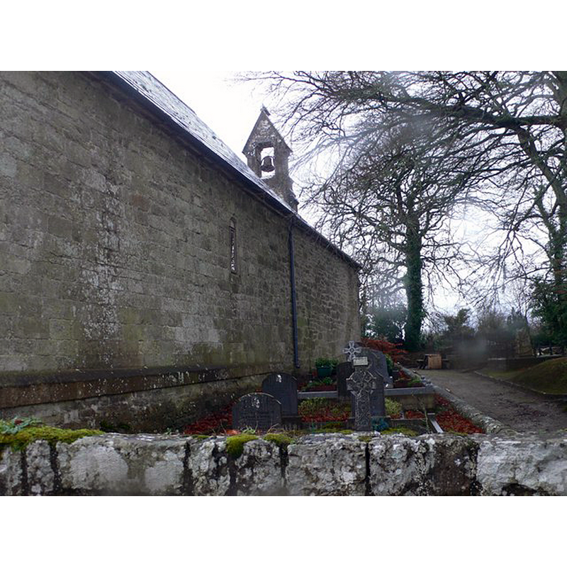
Image copyright © Eirian Evans, 2009
CC-BY-SA-2.5
Results: 2 records
view of church exterior - northeast side - detail
Scene Description: Source caption: "St Cronan's church, Tuamgraney, St Cronan founded a church on this site in the 6th century but was plundered by the Vikings in 886 and 949 and the present church was built shortly after that, with additions in the 12th and 19th centuries. It is said to be the oldest church to be in continuous use in all of Ireland, Scotland, England and Wales. Also it is recorded that Brian Boru used this church and provided for its ongoing repairs."
Copyright Statement: Image copyright © Eirian Evans, 2009
Image Source: digital photograph 27 November 2009 by Eirian Evans [https://www.geograph.org.uk/photo/1601563] [accessed 28 April 2023]
Copyright Instructions: CC-BY-SA-2.5
view of stoup in context
![although described as 'font' in various sources [cf. FontNotes] it is more likely a holy-water stoup](/static-50478a99ec6f36a15d6234548c59f63da52304e5/compressed/1230428001_compressed.png)
Scene Description: although described as 'font' in various sources [cf. FontNotes] it is more likely a holy-water stoup
Copyright Statement: Image copyright © The Standing Stone, 2023
Image Source: digital photograph in The Standing Stone [http://www.thestandingstone.ie/2022/01/st-cronans-church-tuamgraney-co-clare.html]
Copyright Instructions: Permission requested (e-mail of 28 April 2023)
INFORMATION
Font ID: 00840TUA
Object Type: Stoup?
Font Century and Period/Style: Medieval
Church / Chapel Name: St. Cronan (C. of I.)
Font Location in Church: Inside the church, by the entranceway, tight side
Church Patron Saint(s): St. Cronan
Church Notes: mid-10thC church built on site of mid-6thC wooden monastery; plundered by Vikings 9th and 10thC; enlarged 12thC; modified and restored 19thC
Church Address: Ballyquin, Waterpark, Tuamgraney, Co. Clare, Ireland
Site Location: Clare, Munster, Republic of Ireland, Europe
Directions to Site: Tuamgraney is located off the R463, just inland of Scarriff Bay, on the SW shores of Lough Derg, 22-23 km W of Nenagh.
Ecclesiastic Region: Diocese of Tuam, Limerick and Killaloe
Additional Comments: disappeared font? (the one from the 12thC or earlier church here)
Font Notes:
Click to view
Pike (1989) reports it as "inspected but not catalogued"; no other details given. The Phaidon guide (Mehling, 1985) dates the church to the 10th century with 12th-century additions. The entry for Tuamgraney in the CRSBI [https://www.crsbi.ac.uk/view-item?i=15302] [accessed 26 April 2023] notes and illustrates "a plain font of uncertain date […] In W section of church. Plain hemispherical bowl with a broad fillet at the rim, the sides flaring outwards slightly at the bottom. Columnar support resting on square base, broken at one corner, and with circular mouldings around hollow for base of column. No sculptural decoration. Date uncertain […] Dimensions h. of bowl 0.35 m diam. of bowl 0.57 m". It is an unremarkable object that looks more like a holy-water stoup; it consists of a roughly hemispherical basin with a broad flat moulding below the upper rim as its only decoration; raised on a plain tound pedestal base and a round-to-square lower base; stands on a modern plinth; one of the corners of the lower base shows considerable damage. No cover present. [NB: the shape, size and location by the entranceway suggest this be a stoup, not a font].
COORDINATES
UTM: 29U 530982 5860875
Latitude & Longitude (Decimal): 52.896667, -8.539444
Latitude & Longitude (DMS): 52° 53′ 48″ N, 8° 32′ 22″ W
MEDIUM AND MEASUREMENTS
Material: stone, type unknown
Font Shape: hemispheric, mounted
Basin Interior Shape: round
Basin Exterior Shape: round
Diameter (includes rim): 57 cm*
Basin Total Height: 35 cm*
Notes on Measurements: * CRSBI [cf. FontNotes]
REFERENCES
- Mehling, Franz N., Great Britain and Ireland: a Phaidon Cultural Guide, Englewood Cliffs, NJ: Prentice-Hall, 1985, p. 469
- Pike, Joan H.K., "Medieval Fonts of Ireland", [Supplied courtesy of The Dept. of the History of Art, Trinity College, Dublin], [Ireland]: [Privately printed], 1989, p. 56