Mullagh
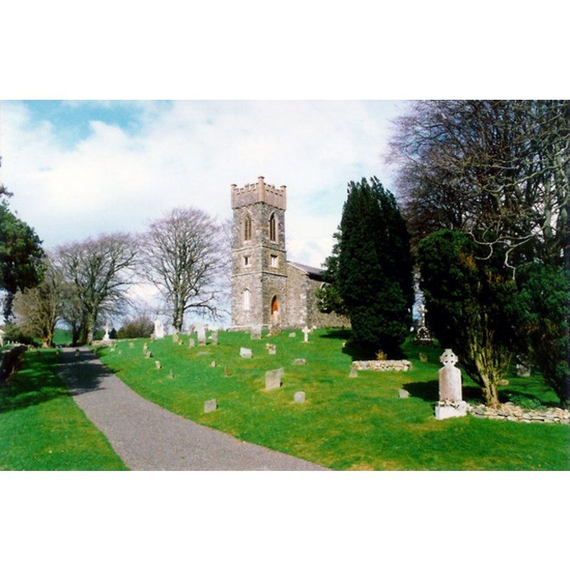
Image copyright © Kieran Campbell, 1994
CC-BY-SA-2.0
Results: 3 records
view of church exterior in context - southwest view
Scene Description: Source caption: "Church and graveyard at Mullagh, Co. Cavan Early-19th century Church of Ireland on ancient site known as 'Teampaill Ceallaigh' or Templekelly, associated with St. Killian."
Copyright Statement: Image copyright © Kieran Campbell, 1994
Image Source: digital image of a 23 April 1994 by Kieran Campbell [https://commons.wikimedia.org/wiki/File:Church_and_graveyard_at_Mullagh,_Co._Cavan_-_geograph.org.uk_-_610368.jpg] [accessed 25 April 2023]
Copyright Instructions: CC-BY-SA-2.0
design element - motifs - ribbon


design element - motifs - foliage
Scene Description: with perhaps a heart-shaped motif
INFORMATION
Font ID: 00837MUL
Object Type: Baptismal Font1
Font Century and Period/Style: Medieval
Church / Chapel Name: Parish Church of St. Killian (C. of I.), Mullagh [orig. from the church at Enniscoffey?]
Font Location in Church: Inside the church at Mullagh
Previous Font Location(s): originally from Enniscoffey/ Inis Cofaigh?
Church Notes: the present Church of Ireland parish church in Mullagh dates from 1819 -- the ruins of the Church of Ireland building in Enniscoffey
Church Address: [NB: address & coordinates are for Mullagh] R194, Glebe, Co. Cavan, Ireland
Site Location: Cavan, Ulster, Republic of Ireland, Europe
Directions to Site: Mullagh is located off (S) the R194, NW of Kells, about 25 km SE of Cavan; leave the N3 at Virginia and take the R194 directly to Mullagh for about 10 km -- Coordinates for Enniscoffey church ruins are Lat: 53.459201, Long: -7.266823
Font Notes:
Click to view
Roe (1968: 87) describes this as a "finely made vessel [...] well-proportioned and octagonal in shape with shallow chamfered underpanels" and reports it as said to have been brought to Mullagh in 1956 from the churchyard of Enniscoffey where it had been buried. Roe (ibid.) identifies "a flat endless ribbon turned into a loop at each corner of the panel", and another, "now greatly defaced but may have consisted of a heart-shaped design with foliate(?) embellishments". Pike (1989: 56) reports a font at Mullagh as "inspected but not catalogued."
COORDINATES
UTM: 29U 633978 5964770
Latitude & Longitude (Decimal): 53.8142, -6.965
Latitude & Longitude (DMS): 53° 48′ 51.12″ N, 6° 57′ 54″ W
MEDIUM AND MEASUREMENTS
Material: stone, type unknown
Font Shape: octagonal, mounted
Basin Exterior Shape: octagonal
Drainage System: centre hole in basin
Rim Thickness: 5.6 cm*
Diameter (inside rim): 43.2 cm* (35.6 at bottom)*
Height of Basin Side: 23 cm*
Basin Upper Panel Dimensions: 23 x 23 tapering to 19 cm*
Basin Lower Panel Dimensions: 16.5 x 19 tapering to 14 cm*
Trapezoidal Basin: 54.4 cm (width)(calculated)
Notes on Measurements: * Roe (1968: 87)
REFERENCES
- Pike, Joan H.K., "Medieval Fonts of Ireland", [Supplied courtesy of The Dept. of the History of Art, Trinity College, Dublin], [Ireland]: [Privately printed], 1989, p. 56
- Roe, Helen M., Medieval Fonts of Meath, Longford, Ireland: Meath Archaeological and Historical Society, 1968, p. 87