Clee / Cleia / Old Clee
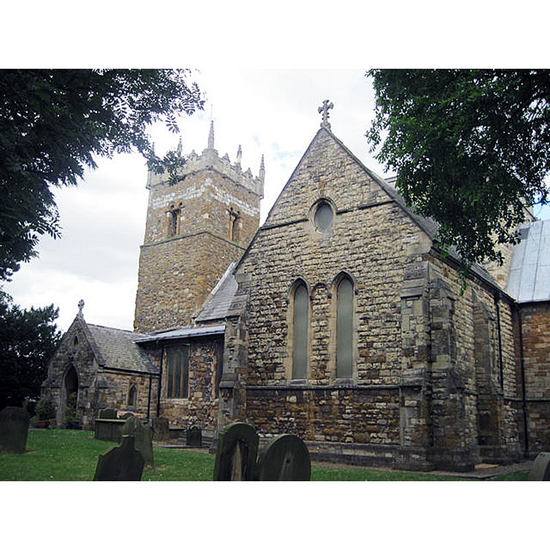
Image copyright © John Firth, 2010
CC-BY-SA-2.5
Results: 2 records
view of church exterior - southeast view
Scene Description: Source caption: "Holy Trinity Old Clee"
Copyright Statement: Image copyright © John Firth, 2010
Image Source: digital photograph 5 July 2010 by John Firth [https://www.geograph.org.uk/photo/1957873] [accessed 21 April 2023]
Copyright Instructions: CC-BY-SA-2.5
design element - motifs - rope moulding
![[cf. FontNotes]](/static-50478a99ec6f36a15d6234548c59f63da52304e5/others/image_not_available.jpg)
Scene Description: [cf. FontNotes]
![[cf. FontNotes]](/static-50478a99ec6f36a15d6234548c59f63da52304e5/bsi-testing-site/others/image_not_available.jpg)
INFORMATION
Font ID: 00796CLE
Object Type: Baptismal Font1
Font Century and Period/Style: 12th century, Norman
Church / Chapel Name: Parish Church of the Holy Trinity and St. Mary the Virgin
Font Location in Church: Inside the church
Church Patron Saint(s): The Holy Trinity & St. Mary the Virgin
Church Notes: Anglo-Saxon tower ca. 1050?
Church Address: 17 Drake Ave, Grimsby DN32 8JD, UK
Site Location: Lincolnshire, East Midlands, England, United Kingdom
Directions to Site: Located off the A46 [aka Clee Rd], 3 km ESE of Grimsby [now practically a suburb], on the S shore of the mouth of the Humber river
Historical Region: Hundred of Bradley [in Domesday]
Font Notes:
Click to view
GET PICS https://www.geograph.org.uk/photo/85770
There are five entries for [Old] Clee in the Domesday survey [https://opendomesday.org/place/TA2908/old-clee/] [accessed 19 April 2023] none of which mentions cleric or church in it. Lewis' Dictionary of 1848 reports "an old circular font" here. Bond (1908) argues that this is yet another font that had been previously dated too early due to the crudeness of the figures and the uncouth ornamentation. Described simply as a noteworthy example of Norman fonts in Cox (1907). Noted in Pevsner, Harris and Antram (1989): "Parish church. C11 Saxo-Norman west tower with C14-C15 parapet; nave arcades of c1170-90; crossing, transepts and chancel dated 1192. Reseated 1858, externally restored 1878 by Joseph Fowler of Louth, with new north and south transept walls, chancel, porch and crossing tower; further restorations 1935-7 […] A church notable for its Saxon and Norman work […] Norman, of tub shape, with a rope band at the top." The entry for this church in Historic England [Listing NGR: TA2899108454] notes: "
There are five entries for [Old] Clee in the Domesday survey [https://opendomesday.org/place/TA2908/old-clee/] [accessed 19 April 2023] none of which mentions cleric or church in it. Lewis' Dictionary of 1848 reports "an old circular font" here. Bond (1908) argues that this is yet another font that had been previously dated too early due to the crudeness of the figures and the uncouth ornamentation. Described simply as a noteworthy example of Norman fonts in Cox (1907). Noted in Pevsner, Harris and Antram (1989): "Parish church. C11 Saxo-Norman west tower with C14-C15 parapet; nave arcades of c1170-90; crossing, transepts and chancel dated 1192. Reseated 1858, externally restored 1878 by Joseph Fowler of Louth, with new north and south transept walls, chancel, porch and crossing tower; further restorations 1935-7 […] A church notable for its Saxon and Norman work […] Norman, of tub shape, with a rope band at the top." The entry for this church in Historic England [Listing NGR: TA2899108454] notes: "
COORDINATES
UTM: 30U 695122 5938261
Latitude & Longitude (Decimal): 53.5569, -0.054096
Latitude & Longitude (DMS): 53° 33′ 24.84″ N, 0° 3′ 14.75″ W
MEDIUM AND MEASUREMENTS
Material: stone
Font Shape: tub-shaped
Basin Interior Shape: round
Basin Exterior Shape: round
REFERENCES
- Bond, Francis, Fonts and Font Covers, London: Waterstone, 1985 c1908, p. 139
- Cox, John Charles, English Church Furniture, New York: E.P. Dutton & Co., 1907, p. 208
- Lewis, Samuel, A Topographical Dictionary of England, Comprising the Several Counties, Cities, Boroughs, Corporate and Market Towns, Parishes, Chapelries, and Townships, and the Islands of Guernsy, Jersey, and Man, with Historical and Statistical Descriptions [...], London: S. Lewis, 1831, [www.british-history.ec.uk/report.asp?compid=50882] [accessed 24 January 2007]
- Pevsner, Nikolaus, Lincolnshire, London: Penguin, 1989, p. 345